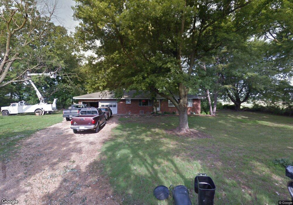
16287 Eddie Bone Rd Pea Ridge, AR 72751
Estimated Value: $284,000 - $586,000
--
Bed
1
Bath
1,392
Sq Ft
$308/Sq Ft
Est. Value
About This Home
This home is located at 16287 Eddie Bone Rd, Pea Ridge, AR 72751 and is currently estimated at $428,969, approximately $308 per square foot. 16287 Eddie Bone Rd is a home located in Benton County with nearby schools including Pea Ridge Primary School, Pea Ridge Intermediate School, and Pea Ridge Junior High School.
Ownership History
Date
Name
Owned For
Owner Type
Purchase Details
Closed on
Jan 17, 2013
Sold by
Bone Ricky L and Evans Debbra K
Bought by
Bone Brently W
Current Estimated Value
Purchase Details
Closed on
Nov 30, 2012
Sold by
Arvest Trust Company
Bought by
Estate Of Darrell W Bone
Purchase Details
Closed on
Apr 17, 2010
Bought by
Dod 4 and Dod 17
Purchase Details
Closed on
Jan 10, 1968
Bought by
Bone E
Create a Home Valuation Report for This Property
The Home Valuation Report is an in-depth analysis detailing your home's value as well as a comparison with similar homes in the area
Home Values in the Area
Average Home Value in this Area
Purchase History
| Date | Buyer | Sale Price | Title Company |
|---|---|---|---|
| Bone Brently W | $93,000 | None Available | |
| Estate Of Darrell W Bone | -- | None Available | |
| Dod 4 | -- | -- | |
| Bone E | -- | -- |
Source: Public Records
Tax History Compared to Growth
Tax History
| Year | Tax Paid | Tax Assessment Tax Assessment Total Assessment is a certain percentage of the fair market value that is determined by local assessors to be the total taxable value of land and additions on the property. | Land | Improvement |
|---|---|---|---|---|
| 2025 | $1,488 | $43,843 | $17,041 | $26,802 |
| 2024 | $1,364 | $43,843 | $17,041 | $26,802 |
| 2023 | $1,240 | $27,360 | $6,890 | $20,470 |
| 2022 | $1,200 | $27,360 | $6,890 | $20,470 |
| 2021 | $1,097 | $27,360 | $6,890 | $20,470 |
| 2020 | $1,025 | $18,370 | $3,100 | $15,270 |
| 2019 | $1,025 | $18,370 | $3,100 | $15,270 |
| 2018 | $1,014 | $18,370 | $3,100 | $15,270 |
| 2017 | $798 | $18,370 | $3,100 | $15,270 |
| 2016 | $798 | $18,370 | $3,100 | $15,270 |
| 2015 | $725 | $13,970 | $1,500 | $12,470 |
| 2014 | $725 | $13,970 | $1,500 | $12,470 |
Source: Public Records
Map
Nearby Homes
- 2720 Murphy St
- 20.74 Acres N Highway 94
- 8.23 AC N Highway 94
- 10890 Gates Ln
- 2721 Kane St
- 2821 Evans St
- 2824 Evans St
- 2716 Kane St
- 2705 Kane St
- 2700 Kane St
- 2704 Kane St
- 2812 Kane St
- 2652 Reynolds St
- 2809 Elliott St
- 2800 Elliott St
- 2709 Bass St
- 2741 Biddie St
- RC Carnegie II Plan at Walnut Hill
- RC Coleman Plan at Walnut Hill
- RC Glenwood Plan at Walnut Hill
- 16149 Eddie Bone Rd
- 16382 N Highway 94
- 16195 Eddie Bone Rd
- 16101 Eddie Bone Rd
- 16395 N Highway 94
- 16375 Don McAllister Rd
- 97.93Ac White Oak Ridge Rd
- 16396 N Highway 94 Unit 16398
- 16378 Don McAllister Rd
- 10558 Andy Buck Rd
- 16097 N Highway 94
- 0 Eddie Bone Rd
- 10506 Andy Buck Rd
- 16438 Don McAllister Rd
- 2566 Chittick St
- 2562 Chittick St
- 2578 Chittick St
- 2570 Chittick St
- 16486 Don McAllister Rd
- 2554 Chittick St