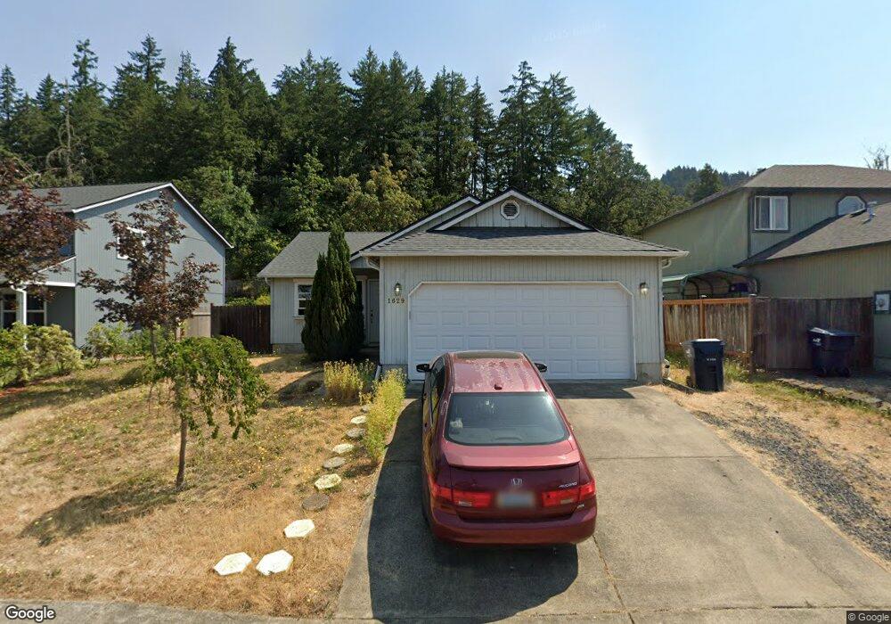
1629 S 60th St Springfield, OR 97478
East Springfield NeighborhoodEstimated Value: $332,000 - $376,000
3
Beds
2
Baths
1,112
Sq Ft
$326/Sq Ft
Est. Value
About This Home
This home is located at 1629 S 60th St, Springfield, OR 97478 and is currently estimated at $362,974, approximately $326 per square foot. 1629 S 60th St is a home located in Lane County with nearby schools including Riverbend Elementary School, Agnes Stewart Middle School, and Thurston High School.
Ownership History
Date
Name
Owned For
Owner Type
Purchase Details
Closed on
Jan 28, 2008
Sold by
Dela O Alma P and De La O Adriana F
Bought by
Dela O Adriana F
Current Estimated Value
Home Financials for this Owner
Home Financials are based on the most recent Mortgage that was taken out on this home.
Original Mortgage
$141,250
Outstanding Balance
$88,430
Interest Rate
6.09%
Mortgage Type
New Conventional
Estimated Equity
$274,544
Purchase Details
Closed on
Jun 27, 2005
Sold by
Reynoso Jaime and Reynoso Mary L
Bought by
Delao Alma P and Delao Adriana F
Home Financials for this Owner
Home Financials are based on the most recent Mortgage that was taken out on this home.
Original Mortgage
$26,560
Interest Rate
5.65%
Mortgage Type
Stand Alone Second
Create a Home Valuation Report for This Property
The Home Valuation Report is an in-depth analysis detailing your home's value as well as a comparison with similar homes in the area
Home Values in the Area
Average Home Value in this Area
Purchase History
| Date | Buyer | Sale Price | Title Company |
|---|---|---|---|
| Dela O Adriana F | -- | First American Title | |
| Delao Alma P | $132,800 | Evergreen Land Title Co |
Source: Public Records
Mortgage History
| Date | Status | Borrower | Loan Amount |
|---|---|---|---|
| Open | Dela O Adriana F | $141,250 | |
| Closed | Delao Alma P | $26,560 | |
| Closed | Delao Alma P | $106,240 |
Source: Public Records
Tax History
| Year | Tax Paid | Tax Assessment Tax Assessment Total Assessment is a certain percentage of the fair market value that is determined by local assessors to be the total taxable value of land and additions on the property. | Land | Improvement |
|---|---|---|---|---|
| 2025 | $3,617 | $197,251 | -- | -- |
| 2024 | $3,559 | $191,506 | -- | -- |
| 2023 | $3,559 | $185,929 | $0 | $0 |
| 2022 | $3,296 | $180,514 | $0 | $0 |
| 2021 | $3,237 | $175,257 | $0 | $0 |
| 2020 | $3,142 | $170,153 | $0 | $0 |
| 2019 | $3,048 | $165,198 | $0 | $0 |
| 2018 | $2,873 | $155,716 | $0 | $0 |
| 2017 | $2,763 | $155,716 | $0 | $0 |
| 2016 | $2,704 | $151,181 | $0 | $0 |
| 2015 | $2,627 | $146,778 | $0 | $0 |
| 2014 | $2,588 | $142,503 | $0 | $0 |
Source: Public Records
Map
Nearby Homes
- 5972 Mount Vernon Rd
- 1981 S 59th St
- 5761 Mt Vernon Rd
- 6050 Pebble Ct
- 967 S 66th Place
- 962 S 66th Place
- 982 S 66th Place
- 5241 Holly St
- 5247 Holly St
- 6225 Forest Ridge Dr
- 0 Forest Ridge Dr Unit 637211360
- 421 S 58th St
- 994 S 67th St
- 0 Forest Ridge Unit 520732026
- 6842 Jessica Dr
- 6884 Forest Ridge Dr
- 6451 Dogwood St
- 5995 Main St
- 5335 Main St Unit 236
- 5335 Main St
- 1643 S 60th St
- 1613 S 60th St
- 1665 S 60th St
- 1599 S 60th St
- 1624 S 60th St
- 1610 S 60th St
- 1640 S 60th St
- 1585 S 60th St
- 1681 S 60th St
- 1658 S 60th St
- 5953 Cinder St
- 1672 S 60th St
- 1631 S 59th St
- 1653 S 59th St
- 5995 Obsidian Ave
- 5907 Cinder St
- 5936 Obsidian Ave
- 1681 S 59th St
- 5944 Cinder St
- 5904 Obsidian Ave
Your Personal Tour Guide
Ask me questions while you tour the home.