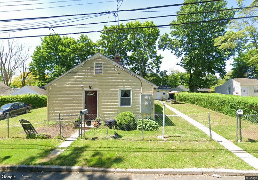
163 Alexander Dr Bridgeport, CT 06606
Brooklawn-Saint Vincent NeighborhoodEstimated Value: $406,000 - $458,000
4
Beds
2
Baths
1,648
Sq Ft
$265/Sq Ft
Est. Value
About This Home
This home is located at 163 Alexander Dr, Bridgeport, CT 06606 and is currently estimated at $436,371, approximately $264 per square foot. 163 Alexander Dr is a home located in Fairfield County with nearby schools including Blackham School, Central High School, and Assumption Catholic School.
Ownership History
Date
Name
Owned For
Owner Type
Purchase Details
Closed on
Dec 2, 2003
Sold by
Throp Martha
Bought by
Robles Ofelio and Robles Maria
Current Estimated Value
Home Financials for this Owner
Home Financials are based on the most recent Mortgage that was taken out on this home.
Original Mortgage
$181,450
Interest Rate
6.4%
Create a Home Valuation Report for This Property
The Home Valuation Report is an in-depth analysis detailing your home's value as well as a comparison with similar homes in the area
Home Values in the Area
Average Home Value in this Area
Purchase History
| Date | Buyer | Sale Price | Title Company |
|---|---|---|---|
| Robles Ofelio | $191,000 | -- | |
| Robles Ofelio | $191,000 | -- |
Source: Public Records
Mortgage History
| Date | Status | Borrower | Loan Amount |
|---|---|---|---|
| Open | Robles Ofelio | $195,744 | |
| Closed | Robles Ofelio | $205,255 | |
| Closed | Robles Ofelio | $201,000 | |
| Closed | Robles Ofelio | $181,450 |
Source: Public Records
Tax History Compared to Growth
Tax History
| Year | Tax Paid | Tax Assessment Tax Assessment Total Assessment is a certain percentage of the fair market value that is determined by local assessors to be the total taxable value of land and additions on the property. | Land | Improvement |
|---|---|---|---|---|
| 2025 | $6,828 | $157,140 | $77,580 | $79,560 |
| 2024 | $6,828 | $157,140 | $77,580 | $79,560 |
| 2023 | $6,828 | $157,140 | $77,580 | $79,560 |
| 2022 | $6,828 | $157,140 | $77,580 | $79,560 |
| 2021 | $6,828 | $157,140 | $77,580 | $79,560 |
| 2020 | $5,775 | $106,960 | $40,520 | $66,440 |
| 2019 | $5,775 | $106,960 | $40,520 | $66,440 |
| 2018 | $5,815 | $106,960 | $40,520 | $66,440 |
| 2017 | $5,815 | $106,960 | $40,520 | $66,440 |
| 2016 | $5,815 | $106,960 | $40,520 | $66,440 |
| 2015 | $6,400 | $151,660 | $49,060 | $102,600 |
| 2014 | $6,400 | $151,660 | $49,060 | $102,600 |
Source: Public Records
Map
Nearby Homes
- 125 Alexander Dr
- 150 Alexander Dr
- 201 High Ridge Dr
- 11 Myron Ave
- 2625 Park Ave Unit 12L
- 2625 Park Ave Unit 5N
- 76 Suburban Ave
- 241 Sampson St
- 2675 Park Ave Unit 3
- 2675 Park Ave Unit 22
- 2445 Park Ave Unit 23
- 1275 Capitol Ave
- 2345 Park Ave
- 1480 Capitol Ave Unit 811
- 1473 Wood Ave
- 356 Taft Ave
- 119 Madison Terrace
- 203 Wayne St
- 105 Tremont Ave Unit E
- 105 Tremont Ave Unit B
- 400 High Ridge Dr Unit 406
- 145 Alexander Dr Unit 147
- 384 High Ridge Dr
- 382 High Ridge Dr Unit 384
- 175 Alexander Dr
- 177 Alexander Dr
- 370 High Ridge Dr
- 152 Alexander Dr
- 422 High Ridge Dr Unit 424
- 164 Alexander Dr
- 176 Alexander Dr
- 11 High Ridge Dr
- 11 High Ridge Dr Unit 11
- 9-11 High Ridge Dr
- 389 High Ridge Dr
- 399 High Ridge Dr Unit 405
- 53 Benson Terrace Unit 55
- 383 High Ridge Dr Unit 389
- 417 High Ridge Dr Unit 423