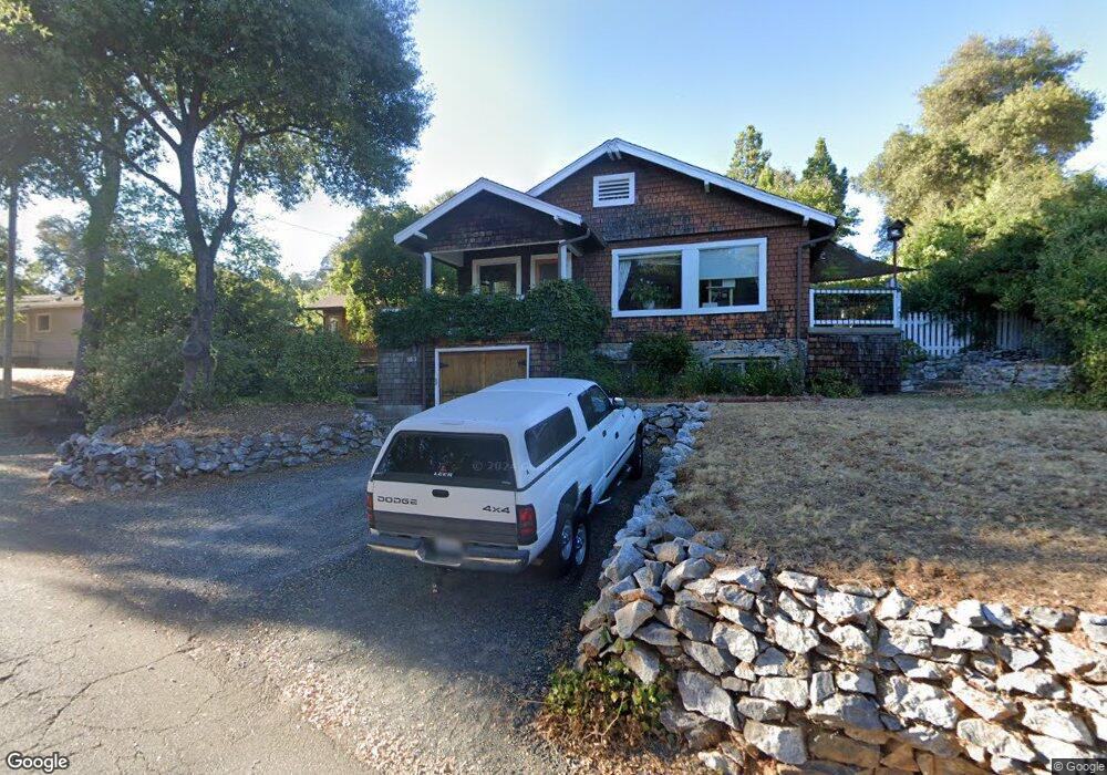
163 Banner Dr Sonora, CA 95370
Estimated Value: $288,000 - $359,000
3
Beds
2
Baths
1,305
Sq Ft
$252/Sq Ft
Est. Value
About This Home
This home is located at 163 Banner Dr, Sonora, CA 95370 and is currently estimated at $329,180, approximately $252 per square foot. 163 Banner Dr is a home located in Tuolumne County with nearby schools including Sonora Elementary School, Sonora High School, and Dario Cassina High School.
Ownership History
Date
Name
Owned For
Owner Type
Purchase Details
Closed on
Sep 7, 2018
Sold by
Hines Raymond and Hines Lisa
Bought by
Hines Raymond A and Hines Lisa M
Current Estimated Value
Purchase Details
Closed on
Mar 3, 2003
Sold by
Hines Raymond A
Bought by
Hines Raymond A and Hines Lisa M
Home Financials for this Owner
Home Financials are based on the most recent Mortgage that was taken out on this home.
Original Mortgage
$102,350
Interest Rate
5.93%
Mortgage Type
Purchase Money Mortgage
Purchase Details
Closed on
Feb 19, 2003
Sold by
Hines Lisa
Bought by
Hines Raymond A
Home Financials for this Owner
Home Financials are based on the most recent Mortgage that was taken out on this home.
Original Mortgage
$102,350
Interest Rate
5.93%
Mortgage Type
Purchase Money Mortgage
Create a Home Valuation Report for This Property
The Home Valuation Report is an in-depth analysis detailing your home's value as well as a comparison with similar homes in the area
Home Values in the Area
Average Home Value in this Area
Purchase History
| Date | Buyer | Sale Price | Title Company |
|---|---|---|---|
| Hines Raymond A | -- | None Available | |
| Hines Raymond A | -- | None Available | |
| Hines Raymond A | -- | First American Title Ins Co | |
| Hines Raymond A | -- | First American Title Ins Co |
Source: Public Records
Mortgage History
| Date | Status | Borrower | Loan Amount |
|---|---|---|---|
| Closed | Hines Raymond A | $102,350 |
Source: Public Records
Tax History
| Year | Tax Paid | Tax Assessment Tax Assessment Total Assessment is a certain percentage of the fair market value that is determined by local assessors to be the total taxable value of land and additions on the property. | Land | Improvement |
|---|---|---|---|---|
| 2025 | $2,782 | $271,773 | $75,330 | $196,443 |
| 2024 | $2,782 | $266,445 | $73,853 | $192,592 |
| 2023 | $2,738 | $261,221 | $72,405 | $188,816 |
| 2022 | $2,686 | $256,100 | $70,986 | $185,114 |
| 2021 | $2,628 | $251,080 | $69,595 | $181,485 |
| 2020 | $2,594 | $248,507 | $68,882 | $179,625 |
| 2019 | $2,506 | $243,635 | $67,532 | $176,103 |
| 2018 | $2,533 | $238,858 | $66,208 | $172,650 |
| 2017 | $2,418 | $234,175 | $64,910 | $169,265 |
| 2016 | $2,370 | $229,585 | $63,638 | $165,947 |
| 2015 | $2,332 | $226,138 | $62,683 | $163,455 |
| 2014 | $2,272 | $221,710 | $61,456 | $160,254 |
Source: Public Records
Map
Nearby Homes
- 15 Roble Rd
- 38 Saratoga Rd
- 832 Shaws Flat Rd
- 696 Shaws Flat Rd
- 138 Steffen Ln
- 20580 Bay Meadows Dr
- 20475 Eureka Dr
- 294 Arbona Cir S
- 20556 Columbia Way
- 20445 W Walnut Dr
- 169 N Shepherd St
- 299 Summit Ave
- 20440 W Walnut Dr
- 91 Summit Ave
- 20991 Jamestown Rd
- 40 Upper Sunset Dr
- 000 Lot 498 Oxbow Ln N
- 56 Bradford St
- 105 Terrace Ave
- 11240 California 49
Your Personal Tour Guide
Ask me questions while you tour the home.