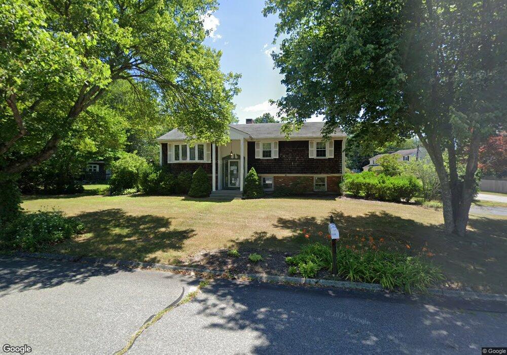
163 Briarbrook Dr Seekonk, MA 02771
Estimated Value: $517,000 - $584,000
3
Beds
3
Baths
1,132
Sq Ft
$487/Sq Ft
Est. Value
About This Home
This home is located at 163 Briarbrook Dr, Seekonk, MA 02771 and is currently estimated at $550,881, approximately $486 per square foot. 163 Briarbrook Dr is a home located in Bristol County with nearby schools including Seekonk High School, St Margaret School, and Providence Country Day School.
Ownership History
Date
Name
Owned For
Owner Type
Purchase Details
Closed on
Jan 1, 1971
Bought by
Lheureux Eugene B and Lheureux Judith A
Current Estimated Value
Create a Home Valuation Report for This Property
The Home Valuation Report is an in-depth analysis detailing your home's value as well as a comparison with similar homes in the area
Home Values in the Area
Average Home Value in this Area
Purchase History
| Date | Buyer | Sale Price | Title Company |
|---|---|---|---|
| Lheureux Eugene B | -- | -- |
Source: Public Records
Mortgage History
| Date | Status | Borrower | Loan Amount |
|---|---|---|---|
| Open | Lheureux Eugene B | $465,000 | |
| Closed | Lheureux Eugene B | $105,000 | |
| Closed | Lheureux Eugene B | $57,000 | |
| Closed | Lheureux Eugene B | $64,500 |
Source: Public Records
Tax History Compared to Growth
Tax History
| Year | Tax Paid | Tax Assessment Tax Assessment Total Assessment is a certain percentage of the fair market value that is determined by local assessors to be the total taxable value of land and additions on the property. | Land | Improvement |
|---|---|---|---|---|
| 2025 | $5,595 | $453,000 | $186,100 | $266,900 |
| 2024 | $5,401 | $437,300 | $186,100 | $251,200 |
| 2023 | $5,211 | $397,500 | $167,000 | $230,500 |
| 2022 | $4,769 | $357,500 | $160,400 | $197,100 |
| 2021 | $4,561 | $336,100 | $142,600 | $193,500 |
| 2020 | $4,274 | $324,500 | $142,300 | $182,200 |
| 2019 | $4,033 | $308,800 | $142,300 | $166,500 |
| 2018 | $3,842 | $287,800 | $142,300 | $145,500 |
| 2017 | $3,723 | $276,600 | $136,200 | $140,400 |
| 2016 | $3,693 | $275,400 | $136,200 | $139,200 |
| 2015 | $3,616 | $273,300 | $136,200 | $137,100 |
Source: Public Records
Map
Nearby Homes
- 420 Chestnut St
- 524 County St
- 62 Chestnut St
- 39 John Alden Rd
- 42 Tee Jay Dr
- 679 County St
- 349 County St
- 442 Taunton Ave
- 25 Pimental Dr
- 824 Taunton Ave
- 30 Rosemarie Dr
- 147 Olney St
- 0 Patterson St Unit 73348933
- 181 Hope St
- 296 Fall River Ave
- 0 Pleasant St
- 0 Milton St Unit 72633661
- 25 Lincoln St
- 358 Olney St
- 698 Fall River Ave
- 23 Alice Dr
- 156 Briarbrook Dr
- 179 Briarbrook Dr
- 172 Briarbrook Dr
- 129 Briarbrook Dr
- 26 Alice Dr
- 188 Briarbrook Dr
- 33 Hammond St
- 21 Hammond St
- 12 Alice Dr
- 18 Briarbrook Dr
- 27 Cindy Dr
- 43 Cindy Dr
- 118 Briarbrook Dr
- 267 Chestnut St
- 275 Chestnut St
- 42 Hammond St
- 7 Cindy Dr
- 34 Hammond St
- 104 Briarbrook Dr