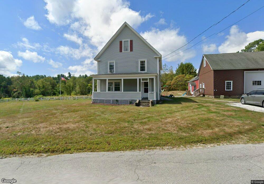
163 Center Rd Lyndeborough, NH 03082
Estimated Value: $490,000 - $516,200
4
Beds
2
Baths
2,534
Sq Ft
$198/Sq Ft
Est. Value
About This Home
This home is located at 163 Center Rd, Lyndeborough, NH 03082 and is currently estimated at $501,550, approximately $197 per square foot. 163 Center Rd is a home located in Hillsborough County with nearby schools including Lyndeborough Central School, Wilton-Lyndeborough Cooperative Middle School, and Wilton-Lyndeborough Cooperative High School.
Ownership History
Date
Name
Owned For
Owner Type
Purchase Details
Closed on
Jul 10, 2025
Sold by
Margaret A Mcentee T A and Margaret Mcentee
Bought by
Mcentee Devin B and Mcentee Hannah
Current Estimated Value
Home Financials for this Owner
Home Financials are based on the most recent Mortgage that was taken out on this home.
Original Mortgage
$312,000
Outstanding Balance
$310,946
Interest Rate
6.89%
Mortgage Type
New Conventional
Estimated Equity
$190,604
Create a Home Valuation Report for This Property
The Home Valuation Report is an in-depth analysis detailing your home's value as well as a comparison with similar homes in the area
Home Values in the Area
Average Home Value in this Area
Purchase History
| Date | Buyer | Sale Price | Title Company |
|---|---|---|---|
| Mcentee Devin B | $495,000 | -- | |
| Mcentee Devin B | $495,000 | -- |
Source: Public Records
Mortgage History
| Date | Status | Borrower | Loan Amount |
|---|---|---|---|
| Open | Mcentee Devin B | $312,000 | |
| Closed | Mcentee Devin B | $312,000 |
Source: Public Records
Tax History Compared to Growth
Tax History
| Year | Tax Paid | Tax Assessment Tax Assessment Total Assessment is a certain percentage of the fair market value that is determined by local assessors to be the total taxable value of land and additions on the property. | Land | Improvement |
|---|---|---|---|---|
| 2024 | $9,178 | $354,930 | $90,330 | $264,600 |
| 2023 | $8,439 | $355,009 | $90,409 | $264,600 |
| 2022 | $7,848 | $355,104 | $90,504 | $264,600 |
| 2021 | $7,854 | $355,405 | $90,805 | $264,600 |
| 2020 | $7,584 | $355,405 | $90,805 | $264,600 |
| 2019 | $7,290 | $250,160 | $84,160 | $166,000 |
| 2018 | $7,056 | $250,140 | $84,140 | $166,000 |
| 2017 | $6,939 | $250,140 | $84,140 | $166,000 |
| 2016 | $6,939 | $250,140 | $84,140 | $166,000 |
| 2015 | $6,326 | $250,140 | $84,140 | $166,000 |
| 2013 | $5,927 | $246,940 | $86,640 | $160,300 |
Source: Public Records
Map
Nearby Homes
- 7 Dow Rd
- 134 Falcon Ridge Rd Unit 23
- 51 Singer Brook Rd
- 4 Trow Rd
- 8 Maple St
- 25 Burns Hill Rd
- 344 Elm St Unit 14
- 344 Elm St Unit 16
- 44 Burns Hill Rd
- F-88-7 Aria Hill Dr
- F-88-12 Aria Hill Dr
- F-88-11 Aria Hill Dr
- F-88-10 Aria Hill Dr
- 32 Larch Rd
- Lot F-88-9 Aria Hill Dr
- 30 Robbins Rd
- 43 Boxwood Cir
- 17 Kittredge Rd
- 229 Mont Vernon Rd
- 0 Briar Cliff Dr