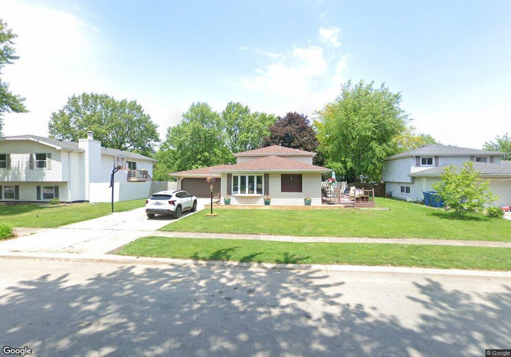
163 Kathy Dr Bourbonnais, IL 60914
Estimated Value: $246,000 - $280,000
4
Beds
2
Baths
1,700
Sq Ft
$152/Sq Ft
Est. Value
About This Home
This home is located at 163 Kathy Dr, Bourbonnais, IL 60914 and is currently estimated at $258,826, approximately $152 per square foot. 163 Kathy Dr is a home located in Kankakee County with nearby schools including Noel Levasseur Elementary School, Liberty Intermediate School, and Bourbonnais Upper Grade Center.
Ownership History
Date
Name
Owned For
Owner Type
Purchase Details
Closed on
Apr 27, 2005
Sold by
Owens Thomas R and Owens Diane M
Bought by
Schmidt Kevin J and Schmidt Christina L
Current Estimated Value
Home Financials for this Owner
Home Financials are based on the most recent Mortgage that was taken out on this home.
Original Mortgage
$152,605
Outstanding Balance
$82,914
Interest Rate
6.5%
Mortgage Type
FHA
Estimated Equity
$175,912
Create a Home Valuation Report for This Property
The Home Valuation Report is an in-depth analysis detailing your home's value as well as a comparison with similar homes in the area
Home Values in the Area
Average Home Value in this Area
Purchase History
| Date | Buyer | Sale Price | Title Company |
|---|---|---|---|
| Schmidt Kevin J | $155,000 | Standard Title |
Source: Public Records
Mortgage History
| Date | Status | Borrower | Loan Amount |
|---|---|---|---|
| Open | Schmidt Kevin J | $152,605 |
Source: Public Records
Tax History
| Year | Tax Paid | Tax Assessment Tax Assessment Total Assessment is a certain percentage of the fair market value that is determined by local assessors to be the total taxable value of land and additions on the property. | Land | Improvement |
|---|---|---|---|---|
| 2024 | $5,625 | $73,923 | $6,562 | $67,361 |
| 2023 | $4,988 | $66,630 | $6,076 | $60,554 |
| 2022 | $4,753 | $61,442 | $5,856 | $55,586 |
| 2021 | $4,529 | $58,507 | $5,727 | $52,780 |
| 2020 | $4,392 | $55,934 | $5,574 | $50,360 |
| 2019 | $4,116 | $52,305 | $5,412 | $46,893 |
| 2018 | $3,997 | $50,823 | $5,332 | $45,491 |
| 2017 | $3,912 | $49,583 | $5,202 | $44,381 |
| 2016 | $3,662 | $46,880 | $5,125 | $41,755 |
| 2015 | $3,743 | $47,260 | $5,074 | $42,186 |
| 2014 | $3,595 | $47,260 | $5,074 | $42,186 |
| 2013 | -- | $47,060 | $5,074 | $41,986 |
Source: Public Records
Map
Nearby Homes
- 172 Anita Dr
- 220 Kathy Dr
- 1582 Mid Court Dr
- 22 Emery Dr
- 9 Hilltop Dr
- 1533 Stefanie Ln
- 1565 Stefanie Ln
- 1356 Eagle Bluff Dr
- 490 Meadows Rd N
- 1230 Eagle Bluff Dr
- 1313 Eagle Bluff Dr
- 375 Meadows Rd N
- 1063 Yale Ave
- 269 Harvard Ave
- Lot 5 Larry Power Rd
- 605 Chase Ct
- 261 Mohawk Dr
- 471 Spring Park Loop
- 817 Stonewall Dr
- 501 Spring Park Loop