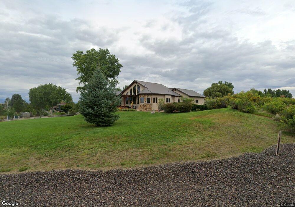
16301 6765 Rd Montrose, CO 81401
Estimated Value: $913,435 - $1,107,000
5
Beds
3
Baths
3,961
Sq Ft
$251/Sq Ft
Est. Value
About This Home
This home is located at 16301 6765 Rd, Montrose, CO 81401 and is currently estimated at $994,359, approximately $251 per square foot. 16301 6765 Rd is a home located in Montrose County with nearby schools including Cottonwood Elementary School, Centennial Middle School, and Montrose High School.
Ownership History
Date
Name
Owned For
Owner Type
Purchase Details
Closed on
Aug 31, 2016
Sold by
Connor Robert T and Connor Karen L
Bought by
Lake Robert T and Lake Linda S
Current Estimated Value
Purchase Details
Closed on
Apr 20, 2001
Sold by
Gilham James Nicholson and Gilham Jeri Bonnell
Bought by
Connor Robert T and Connor Karen L
Purchase Details
Closed on
Oct 5, 1999
Sold by
Tuntland Earl E and Tuntland Sally B
Bought by
Gilham James Nicholson and Gilham Jeri Bonnell
Purchase Details
Closed on
Feb 14, 1991
Sold by
Solar Hills Ranch Ltd
Bought by
Tuntland Earl E and Tuntland Sally B
Create a Home Valuation Report for This Property
The Home Valuation Report is an in-depth analysis detailing your home's value as well as a comparison with similar homes in the area
Home Values in the Area
Average Home Value in this Area
Purchase History
| Date | Buyer | Sale Price | Title Company |
|---|---|---|---|
| Lake Robert T | $486,500 | Land Title Guarantee | |
| Connor Robert T | $95,000 | -- | |
| Gilham James Nicholson | $70,000 | -- | |
| Tuntland Earl E | $27,000 | -- |
Source: Public Records
Tax History Compared to Growth
Tax History
| Year | Tax Paid | Tax Assessment Tax Assessment Total Assessment is a certain percentage of the fair market value that is determined by local assessors to be the total taxable value of land and additions on the property. | Land | Improvement |
|---|---|---|---|---|
| 2024 | $4,169 | $57,840 | $10,270 | $47,570 |
| 2023 | $4,169 | $63,820 | $11,330 | $52,490 |
| 2022 | $2,828 | $40,520 | $6,600 | $33,920 |
| 2021 | $2,913 | $41,690 | $6,790 | $34,900 |
| 2020 | $2,505 | $36,840 | $6,340 | $30,500 |
| 2019 | $2,419 | $35,350 | $6,340 | $29,010 |
| 2018 | $2,291 | $32,630 | $5,320 | $27,310 |
| 2017 | $2,273 | $32,630 | $5,320 | $27,310 |
| 2016 | $1,535 | $30,360 | $5,350 | $25,010 |
| 2015 | $2,044 | $30,360 | $5,350 | $25,010 |
| 2014 | $1,967 | $31,240 | $5,350 | $25,890 |
Source: Public Records
Map
Nearby Homes
- 16168 6794 Ct
- 16303 6760 Rd
- 2231 Hill St
- Lot 11 Galway Ct
- Lot 10 Galway Ct
- Lot 9 Galway Ct
- 3161 Silver Fox Dr
- Lot 8 Galway Ct
- Lot 14 Killarney Ln
- 2308 Mead Ln
- 3004 Silver Fox Dr
- 2132 Patriot Ct
- Lot 17 Killarney Ln
- 2941 Lost Creek Rd N
- Lot 7 Galway Ct
- 2001 Constitution Loop
- TBD Lot 3 E Oak Grove Rd
- TBD Lot 2 E Oak Grove Rd
- 3310 Donnegal Dr
- 3302 Donnegal Dr
- 6765 Road
- 67601 Oakridge Ln
- 16280 6765 Rd
- 67610 Oak Wood Dr
- 67561 Oak Wood Dr
- 16318 6765 Rd
- 67571 Oakridge Ln
- 67578 Oak Wood Dr
- 16306 6765 Rd
- 16222 6765 Rd
- 6765 Rd
- 16330 6750 Rd
- 16187 6765 Rd
- 67522 Oak Wood Dr
- 67501 Oak Wood Dr
- 67533 Oakridge Ln
- 67540 Oakridge Ln
- 16313 6750 Rd
- 16300 6740 Rd
- 16153 6765 Rd