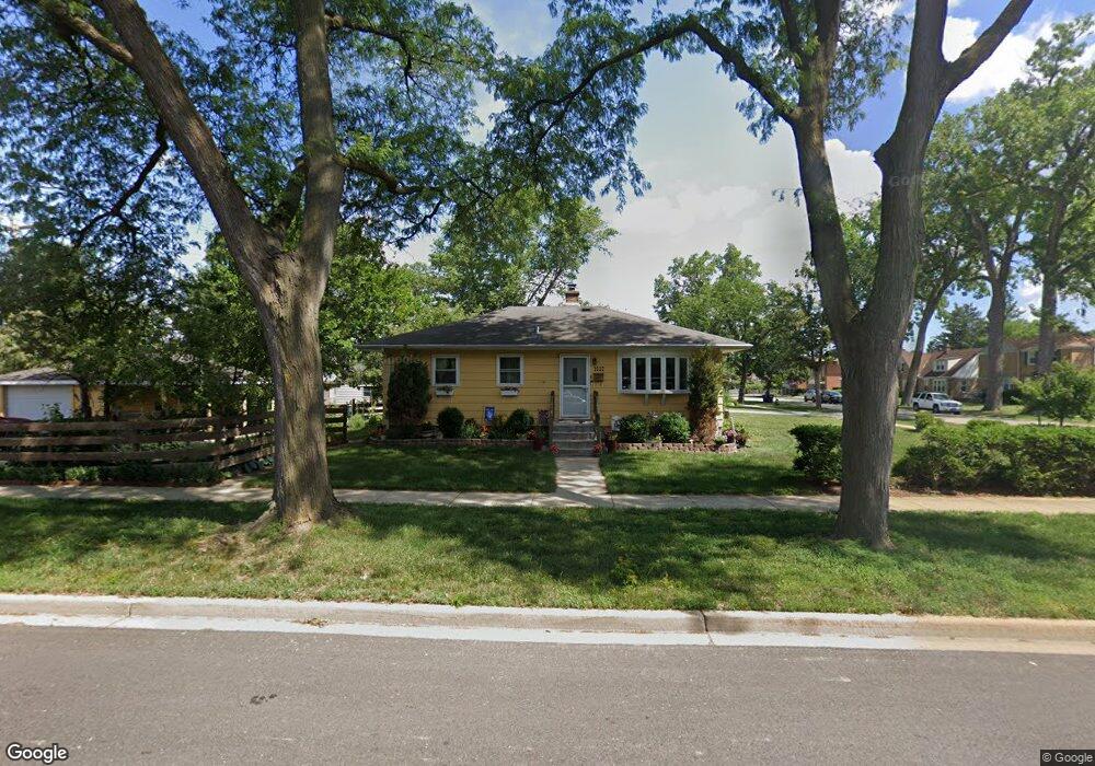
1632 Riverview Ave Des Plaines, IL 60018
Estimated Value: $331,134 - $385,000
3
Beds
1
Bath
913
Sq Ft
$393/Sq Ft
Est. Value
About This Home
This home is located at 1632 Riverview Ave, Des Plaines, IL 60018 and is currently estimated at $358,784, approximately $392 per square foot. 1632 Riverview Ave is a home located in Cook County with nearby schools including South Elementary School, Algonquin Middle School, and Maine West High School.
Ownership History
Date
Name
Owned For
Owner Type
Purchase Details
Closed on
Jun 30, 2006
Sold by
Arceo Virgilio P and Arceo Celia B
Bought by
Vincent Derek R and Vincent Kimberly S
Current Estimated Value
Home Financials for this Owner
Home Financials are based on the most recent Mortgage that was taken out on this home.
Original Mortgage
$217,600
Outstanding Balance
$126,936
Interest Rate
6.72%
Mortgage Type
Unknown
Estimated Equity
$231,848
Create a Home Valuation Report for This Property
The Home Valuation Report is an in-depth analysis detailing your home's value as well as a comparison with similar homes in the area
Home Values in the Area
Average Home Value in this Area
Purchase History
| Date | Buyer | Sale Price | Title Company |
|---|---|---|---|
| Vincent Derek R | $272,000 | Cst |
Source: Public Records
Mortgage History
| Date | Status | Borrower | Loan Amount |
|---|---|---|---|
| Open | Vincent Derek R | $217,600 |
Source: Public Records
Tax History
| Year | Tax Paid | Tax Assessment Tax Assessment Total Assessment is a certain percentage of the fair market value that is determined by local assessors to be the total taxable value of land and additions on the property. | Land | Improvement |
|---|---|---|---|---|
| 2025 | $5,717 | $26,000 | $6,220 | $19,780 |
| 2024 | $5,717 | $25,000 | $5,183 | $19,817 |
| 2023 | $5,553 | $25,000 | $5,183 | $19,817 |
| 2022 | $5,553 | $25,000 | $5,183 | $19,817 |
| 2021 | $4,027 | $16,430 | $4,319 | $12,111 |
| 2020 | $4,028 | $16,430 | $4,319 | $12,111 |
| 2019 | $4,045 | $18,461 | $4,319 | $14,142 |
| 2018 | $3,831 | $16,245 | $3,801 | $12,444 |
| 2017 | $3,781 | $16,245 | $3,801 | $12,444 |
| 2016 | $4,828 | $19,872 | $3,801 | $16,071 |
| 2015 | $3,691 | $14,831 | $3,282 | $11,549 |
| 2014 | $4,578 | $18,036 | $3,282 | $14,754 |
| 2013 | $4,446 | $18,036 | $3,282 | $14,754 |
Source: Public Records
Map
Nearby Homes
- 1645 Illinois St
- 1689 S Elm St
- 1696 S Elm St
- 1445 Everett Ave
- 1721 Prospect Ave
- 1640 S River Rd
- 1700 E Forest Ave
- 1990 Berry Ln
- 1080 Bogart St
- 1922 Fargo Ave
- 1370 Fargo Ave Unit E
- 2220 S Chestnut St
- 1630 Henry Ave
- 1524 Oakwood Ave
- 1638 Oakwood Ave
- 1629 E Touhy Ave
- 1641 E Touhy Ave
- 1380 Oakwood Ave Unit 306
- 1649 Ashland Ave Unit 501
- 1394 Carol Ln
Your Personal Tour Guide
Ask me questions while you tour the home.