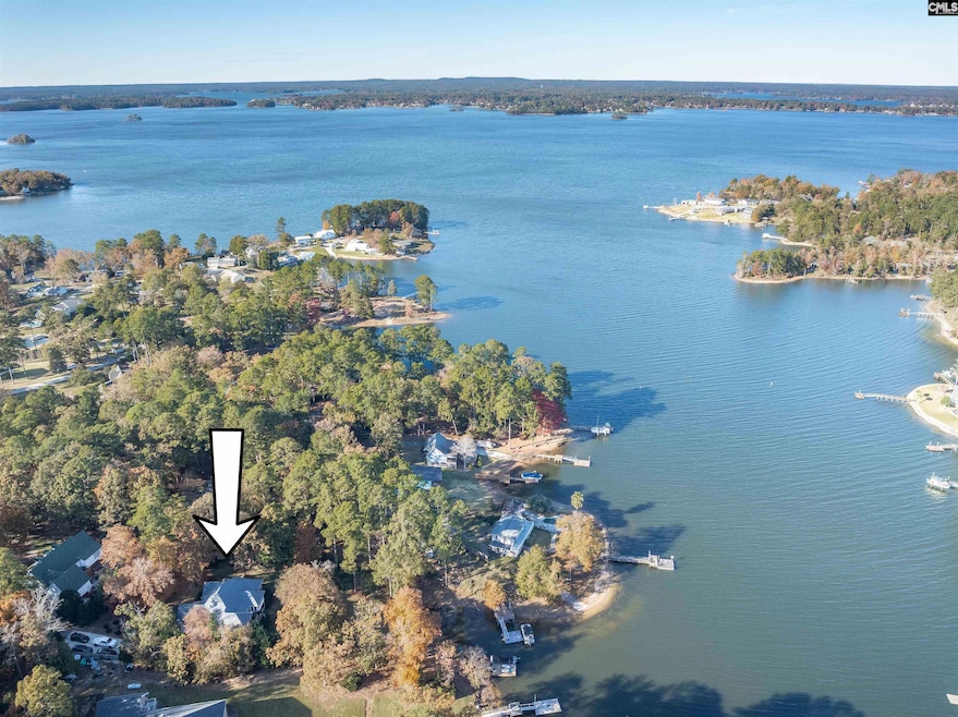

1633 Barracks Dr Gilbert, SC 29054
Estimated payment $5,087/month
Highlights
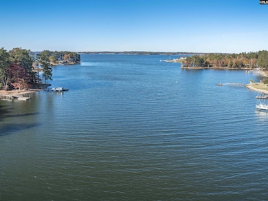
- 213 Feet of Waterfront
- Marble Flooring
- Main Floor Primary Bedroom
- Cathedral Ceiling
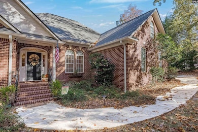
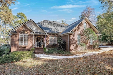
- Traditional Architecture
- 1 Fireplace
About This Home
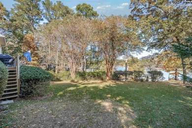
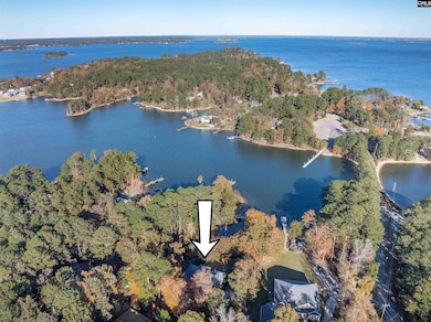
Ultra-Private All-Brick Lakefront Retreat on Lake Murray-Discover this stunning, all-brick lake home on nearly one acre of serene waterfront, complete with a private dock. Spanning just over 2,700 square feet, this residence offers four spacious bedrooms, each with access to a bathroom, creating the perfect balance of comfort and privacy. Step through the formal entryway and enjoy immediate access to all the home’s elegant formal spaces, including a cathedral-ceiling office with custom built-ins — ideal for working from home, writing, or quiet reading. The grand great room impresses with soaring ceilings, custom built-ins, a large gas fireplace accented with exquisite stonework, and beautiful hardwood floors throughout. Entertain effortlessly in the expansive sunroom, featuring floor-to-ceiling windows that flood the space with natural light and frame breathtaking lake views from every angle. The luxurious owner’s suite is a true retreat, showcasing cathedral ceilings, panoramic water views, and a divine en suite bath with dual custom granite vanities, a deep walk-in shower, oversized closets, and a large soaking tub. Outdoors, enjoy your own private lake oasis — nearly an acre of tranquility with a secluded dock perfect for quiet mornings or sunset relaxation. For added convenience, a creative half bath is tucked away on the lower terrace, designed for easy lake-day access. Experience the best of Lake Murray living — privacy, elegance, and endless waterfront beauty, all in one remarkable property. Disclaimer: CMLS has not reviewed and, therefore, does not endorse vendors who may appear in listings.
Home Details
Home Type
- Single Family
Year Built
- Built in 2000
Lot Details
- 0.94 Acre Lot
- 213 Feet of Waterfront
- Property Located on Lake Murray
Parking
- 2 Car Garage
Home Design
- Traditional Architecture
- Four Sided Brick Exterior Elevation
Interior Spaces
- 2,705 Sq Ft Home
- 1.5-Story Property
- Cathedral Ceiling
- 1 Fireplace
- French Doors
- Crawl Space
- Laundry on main level
Flooring
- Wood
- Marble
Bedrooms and Bathrooms
- 4 Bedrooms
- Primary Bedroom on Main
- Soaking Tub
Schools
- Gilbert Elementary And Middle School
- Gilbert High School
Utilities
- Central Heating and Cooling System
- Well
- Septic System
Community Details
- No Home Owners Association
Map
Home Values in the Area
Average Home Value in this Area
Tax History
| Year | Tax Paid | Tax Assessment Tax Assessment Total Assessment is a certain percentage of the fair market value that is determined by local assessors to be the total taxable value of land and additions on the property. | Land | Improvement |
|---|---|---|---|---|
| 2024 | -- | $33,000 | $10,152 | $22,848 |
| 2023 | $16,363 | $33,000 | $10,152 | $22,848 |
| 2022 | $15,737 | $33,000 | $10,152 | $22,848 |
| 2020 | $15,826 | $33,000 | $10,152 | $22,848 |
| 2019 | $16,364 | $33,000 | $8,460 | $24,540 |
| 2018 | $2,144 | $14,046 | $5,640 | $8,406 |
| 2017 | $2,080 | $14,046 | $5,640 | $8,406 |
| 2016 | $2,061 | $14,046 | $5,640 | $8,406 |
| 2014 | $2,062 | $14,697 | $6,005 | $8,692 |
| 2013 | -- | $14,700 | $6,010 | $8,690 |
Property History
| Date | Event | Price | List to Sale | Price per Sq Ft |
|---|---|---|---|---|
| 12/01/2025 12/01/25 | Pending | -- | -- | -- |
| 11/12/2025 11/12/25 | For Sale | $829,000 | -- | $306 / Sq Ft |
Purchase History
| Date | Type | Sale Price | Title Company |
|---|---|---|---|
| Special Warranty Deed | -- | None Listed On Document | |
| Warranty Deed | $550,000 | None Available | |
| Quit Claim Deed | $108,000 | None Available | |
| Interfamily Deed Transfer | -- | -- |
Mortgage History
| Date | Status | Loan Amount | Loan Type |
|---|---|---|---|
| Previous Owner | $420,000 | New Conventional |
Source: Consolidated MLS (Columbia MLS)
MLS Number: 621552
APN: 002423-03-012
Disclaimer: Certain information contained herein is derived from information provided by parties other than Homes.com. All information provided is deemed reliable, but is not guaranteed to be accurate and should be independently verified.
![]() IDX information is provided exclusively for personal, non-commercial use, and may not be used for any purpose other than to identify prospective properties consumers may be interested in purchasing. Information is deemed reliable but not guaranteed.
IDX information is provided exclusively for personal, non-commercial use, and may not be used for any purpose other than to identify prospective properties consumers may be interested in purchasing. Information is deemed reliable but not guaranteed.
- 1459 Bombing Range Rd
- 1233 Shull Island Rd
- 1148 Shull Island Rd
- 1305 Rock Island Rd
- 180 Lillian St
- 417 Dot Ct
- 870 Shore Rd
- 0 Misty Cir Unit 566318
- 148 Pintail Lake Dr
- 274 Pintail Lake Dr
- 1 Downing Cir
- 278 Pintail Lake Dr
- 110 Wood Duck Dr
- 64 Downing Cir
- 0 Counts Ferry Rd Unit LOT 5
- 0 Counts Ferry Rd Unit LOT 6
- 0 Counts Ferry Rd Unit LOT 4
- 0 Counts Ferry Rd Unit LOT 2
- 0 Counts Ferry Rd Unit LOT 7
- 0 Counts Ferry Rd Unit LOT 1

Ask me questions while you tour the home.