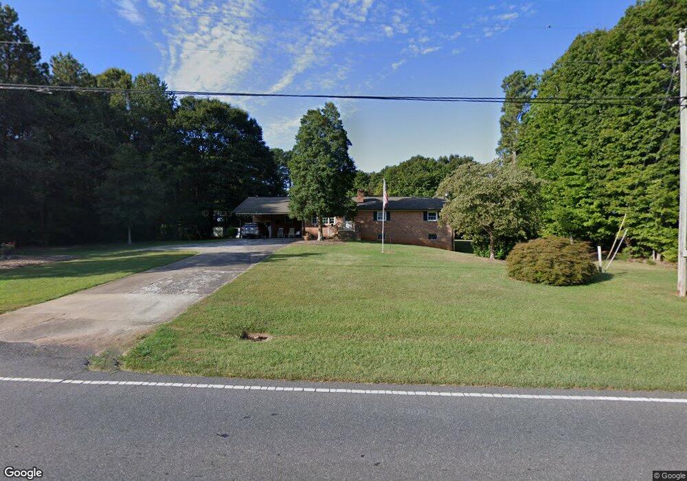
1633 W Highway 27 Lincolnton, NC 28092
Estimated Value: $321,000 - $432,627
4
Beds
2
Baths
1,761
Sq Ft
$215/Sq Ft
Est. Value
About This Home
This home is located at 1633 W Highway 27, Lincolnton, NC 28092 and is currently estimated at $378,657, approximately $215 per square foot. 1633 W Highway 27 is a home located in Lincoln County with nearby schools including Norris S. Childers Elementary School, West Lincoln Middle, and West Lincoln High School.
Ownership History
Date
Name
Owned For
Owner Type
Purchase Details
Closed on
Apr 5, 2016
Sold by
Ledbetter Karen C and Ledbetter Samuel F
Bought by
Holt Charles H and Holt Freda F
Current Estimated Value
Home Financials for this Owner
Home Financials are based on the most recent Mortgage that was taken out on this home.
Original Mortgage
$129,600
Outstanding Balance
$103,128
Interest Rate
3.73%
Mortgage Type
New Conventional
Estimated Equity
$275,529
Purchase Details
Closed on
Aug 12, 2015
Sold by
Ledbetter Karen C and Ledbetter Samuel F
Bought by
Ledbetter Karen C and Ledbetter Samuel F
Create a Home Valuation Report for This Property
The Home Valuation Report is an in-depth analysis detailing your home's value as well as a comparison with similar homes in the area
Home Values in the Area
Average Home Value in this Area
Purchase History
| Date | Buyer | Sale Price | Title Company |
|---|---|---|---|
| Holt Charles H | $162,000 | None Available | |
| Ledbetter Karen C | -- | None Available |
Source: Public Records
Mortgage History
| Date | Status | Borrower | Loan Amount |
|---|---|---|---|
| Open | Holt Charles H | $129,600 |
Source: Public Records
Tax History Compared to Growth
Tax History
| Year | Tax Paid | Tax Assessment Tax Assessment Total Assessment is a certain percentage of the fair market value that is determined by local assessors to be the total taxable value of land and additions on the property. | Land | Improvement |
|---|---|---|---|---|
| 2025 | $2,607 | $388,882 | $78,802 | $310,080 |
| 2024 | $2,587 | $388,882 | $78,802 | $310,080 |
| 2023 | $2,582 | $388,882 | $78,802 | $310,080 |
| 2022 | $2,029 | $253,616 | $61,845 | $191,771 |
| 2021 | $2,029 | $253,616 | $61,845 | $191,771 |
| 2020 | $1,863 | $253,616 | $61,845 | $191,771 |
| 2019 | $1,863 | $253,616 | $61,845 | $191,771 |
| 2018 | $1,799 | $231,515 | $50,715 | $180,800 |
| 2017 | $1,192 | $162,567 | $50,715 | $111,852 |
| 2016 | $1,192 | $162,567 | $50,715 | $111,852 |
| 2015 | $446 | $112,326 | $22,371 | $89,955 |
| 2014 | $473 | $122,684 | $23,774 | $98,910 |
Source: Public Records
Map
Nearby Homes
- 00 George Brown Rd Unit 10
- 00 George Brown Rd Unit 9
- 00 George Brown Rd Unit 8
- 00 George Brown Rd Unit 7
- 00 George Brown Rd Unit 6
- 00 George Brown Rd Unit 5
- 00 George Brown Rd Unit 4
- 00 George Brown Rd Unit 3
- 00 George Brown Rd Unit 2
- 217 Blossom Hill Rd
- 00 Pleasant Grove Church Rd
- 000 Blossom Hill Rd Unit 138
- 1338 Pell Dr
- 1865 Rockdam Creek Ct
- 536 Lincolnview Rd
- 1231 Better Brook Ln
- 792 Mace Ln
- 0 Hillard Ln
- #168 Rolling Rd
- 000 Better Brook Ln
- 131 Gainsville Church Rd
- 187 Gainsville Church Rd
- 00 Hauss Rd
- 162 Gainsville Church Rd
- 1583 W Highway 27
- 130 Gainsville Church Rd
- 1601 W Highway 27
- 207 Gainsville Church Rd
- 1607 W Highway 27
- 1691 W Highway 27
- 200 Gainsville Church Rd
- 1611 W Highway 27 Hwy
- 1611 W Highway 27
- 110 Westover Dr
- 1568 W Highway 27
- 221 Gainsville Church Rd
- 00 W Highway 27 Hwy
- 216 Gainsville Church Rd
- 158 Hauss Rd
- 118 Westover Dr