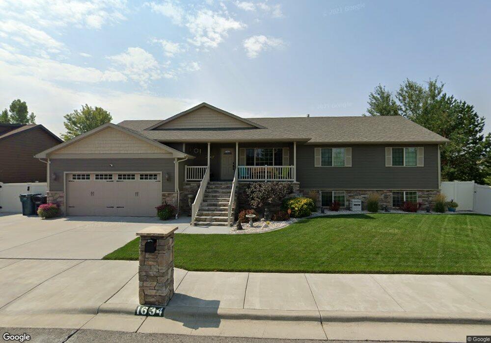
1634 Kit Ln W Billings, MT 59106
West Shiloh NeighborhoodEstimated Value: $554,000 - $608,311
6
Beds
3
Baths
3,344
Sq Ft
$173/Sq Ft
Est. Value
About This Home
This home is located at 1634 Kit Ln W, Billings, MT 59106 and is currently estimated at $579,078, approximately $173 per square foot. 1634 Kit Ln W is a home located in Yellowstone County with nearby schools including Meadowlark School, Ben Steele Middle School, and Billings West High School.
Ownership History
Date
Name
Owned For
Owner Type
Purchase Details
Closed on
Sep 30, 2025
Sold by
Means Elizabeth
Bought by
Means Gabriel
Current Estimated Value
Purchase Details
Closed on
Jan 15, 2010
Sold by
Gountanis Stephen J
Bought by
Arlint Raymond L and Arlint Dawn C
Home Financials for this Owner
Home Financials are based on the most recent Mortgage that was taken out on this home.
Original Mortgage
$244,000
Interest Rate
4.68%
Mortgage Type
New Conventional
Purchase Details
Closed on
Aug 10, 2009
Sold by
Gountanis John G
Bought by
Gountanis Stephen J
Purchase Details
Closed on
Jan 31, 2008
Sold by
Kenmark Corp
Bought by
Gountanis John G
Create a Home Valuation Report for This Property
The Home Valuation Report is an in-depth analysis detailing your home's value as well as a comparison with similar homes in the area
Home Values in the Area
Average Home Value in this Area
Purchase History
| Date | Buyer | Sale Price | Title Company |
|---|---|---|---|
| Means Gabriel | -- | Stewart Title Company | |
| Arlint Raymond L | -- | None Available | |
| Gountanis Stephen J | -- | None Available | |
| Gountanis John G | -- | None Available |
Source: Public Records
Mortgage History
| Date | Status | Borrower | Loan Amount |
|---|---|---|---|
| Previous Owner | Arlint Raymond L | $244,000 |
Source: Public Records
Tax History
| Year | Tax Paid | Tax Assessment Tax Assessment Total Assessment is a certain percentage of the fair market value that is determined by local assessors to be the total taxable value of land and additions on the property. | Land | Improvement |
|---|---|---|---|---|
| 2025 | $5,149 | $622,300 | $98,598 | $523,702 |
| 2024 | $5,149 | $544,200 | $91,401 | $452,799 |
| 2023 | $4,649 | $490,100 | $91,401 | $398,699 |
| 2022 | $3,556 | $376,600 | $0 | $0 |
| 2021 | $3,879 | $376,600 | $0 | $0 |
| 2020 | $3,864 | $359,400 | $0 | $0 |
| 2019 | $3,685 | $359,400 | $0 | $0 |
| 2018 | $3,686 | $353,300 | $0 | $0 |
| 2017 | $3,270 | $353,300 | $0 | $0 |
| 2016 | $3,533 | $353,300 | $0 | $0 |
| 2015 | $3,454 | $353,300 | $0 | $0 |
| 2014 | $2,831 | $152,509 | $0 | $0 |
Source: Public Records
Map
Nearby Homes
- 5827 Foxtail Loop S
- 5912 Foxtail Loop W
- 1303 Wilderness Dr
- 1202 Buffalo Crossing Dr
- 1128 Buffalo Crossing Dr
- 1214 Buffalo Crossing Dr
- 5222 Camp Ln
- 1210 Buffalo Crossing Dr
- 1136 Buffalo Crossing Dr
- 6105 Colton Blvd
- 5825 Mountain Front Ave
- 5432 Cobble Stone Ave
- 1202 Daylight Ln
- 931 N Fork Trail
- 5412 Summer Stone Ave
- 917 Bitterbrush St
- Block 1 Lot 5 Hawk Creek Ave
- 6113 Creek Crossing Rd
- 2605 62nd St W
- 807 Bitterbrush St
Your Personal Tour Guide
Ask me questions while you tour the home.