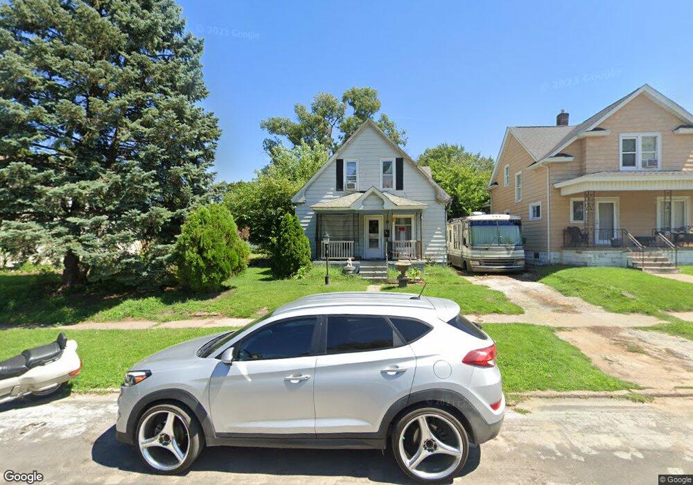
1635 14th St Rock Island, IL 61201
Longview NeighborhoodEstimated Value: $55,000 - $80,000
3
Beds
1
Bath
1,176
Sq Ft
$60/Sq Ft
Est. Value
About This Home
This home is located at 1635 14th St, Rock Island, IL 61201 and is currently estimated at $70,842, approximately $60 per square foot. 1635 14th St is a home located in Rock Island County with nearby schools including Frances Willard Elementary School, Washington Junior High School, and Rock Island High School.
Ownership History
Date
Name
Owned For
Owner Type
Purchase Details
Closed on
Oct 27, 2022
Sold by
Blackstar Stability Distressed Debt Fund
Bought by
Kraus Tony A and Kraus Robin L
Current Estimated Value
Home Financials for this Owner
Home Financials are based on the most recent Mortgage that was taken out on this home.
Original Mortgage
$58,600
Outstanding Balance
$56,628
Interest Rate
6.5%
Mortgage Type
New Conventional
Estimated Equity
$14,214
Purchase Details
Closed on
Oct 2, 2020
Sold by
Home America Fund Iii Lp
Bought by
Distressed Blackstar Stability
Create a Home Valuation Report for This Property
The Home Valuation Report is an in-depth analysis detailing your home's value as well as a comparison with similar homes in the area
Home Values in the Area
Average Home Value in this Area
Purchase History
| Date | Buyer | Sale Price | Title Company |
|---|---|---|---|
| Kraus Tony A | $58,600 | Stewart Title Company | |
| Distressed Blackstar Stability | $31,069 | Home America Fund Iii Lp |
Source: Public Records
Mortgage History
| Date | Status | Borrower | Loan Amount |
|---|---|---|---|
| Open | Kraus Tony A | $58,600 |
Source: Public Records
Tax History Compared to Growth
Tax History
| Year | Tax Paid | Tax Assessment Tax Assessment Total Assessment is a certain percentage of the fair market value that is determined by local assessors to be the total taxable value of land and additions on the property. | Land | Improvement |
|---|---|---|---|---|
| 2024 | $1,755 | $17,200 | $1,748 | $15,452 |
| 2023 | $1,755 | $16,412 | $1,668 | $14,744 |
| 2022 | $1,581 | $15,235 | $1,566 | $13,669 |
| 2021 | $1,565 | $14,621 | $1,503 | $13,118 |
| 2020 | $1,545 | $14,264 | $1,466 | $12,798 |
| 2019 | $1,485 | $14,264 | $1,466 | $12,798 |
| 2018 | $1,485 | $13,984 | $1,437 | $12,547 |
| 2017 | $1,438 | $13,778 | $1,416 | $12,362 |
| 2016 | $1,387 | $13,508 | $1,388 | $12,120 |
| 2015 | $1,330 | $12,804 | $1,316 | $11,488 |
| 2014 | $324 | $12,874 | $1,323 | $11,551 |
| 2013 | $324 | $12,874 | $1,323 | $11,551 |
Source: Public Records
Map
Nearby Homes
- 1625 14 1 2 St
- 1621 14 1 2 St
- 1600 14th St
- 1035 17th Ave
- 1015 18th Ave
- 1234 12th St
- 1901 9 1 2 St
- 1628 18th Ave Unit 10
- 1632 18th Ave Unit 24
- 1215 Glenhurst Ct
- 934 20th Ave
- 1212 Glenhurst Ct
- 1045 12th St Unit 1047
- 1620 20th Ave
- 1600 9th St
- 1635 20th St
- 2153 14th St
- 1900 13th Ave
- 1230 19th St Unit 32
- 2005 17th St