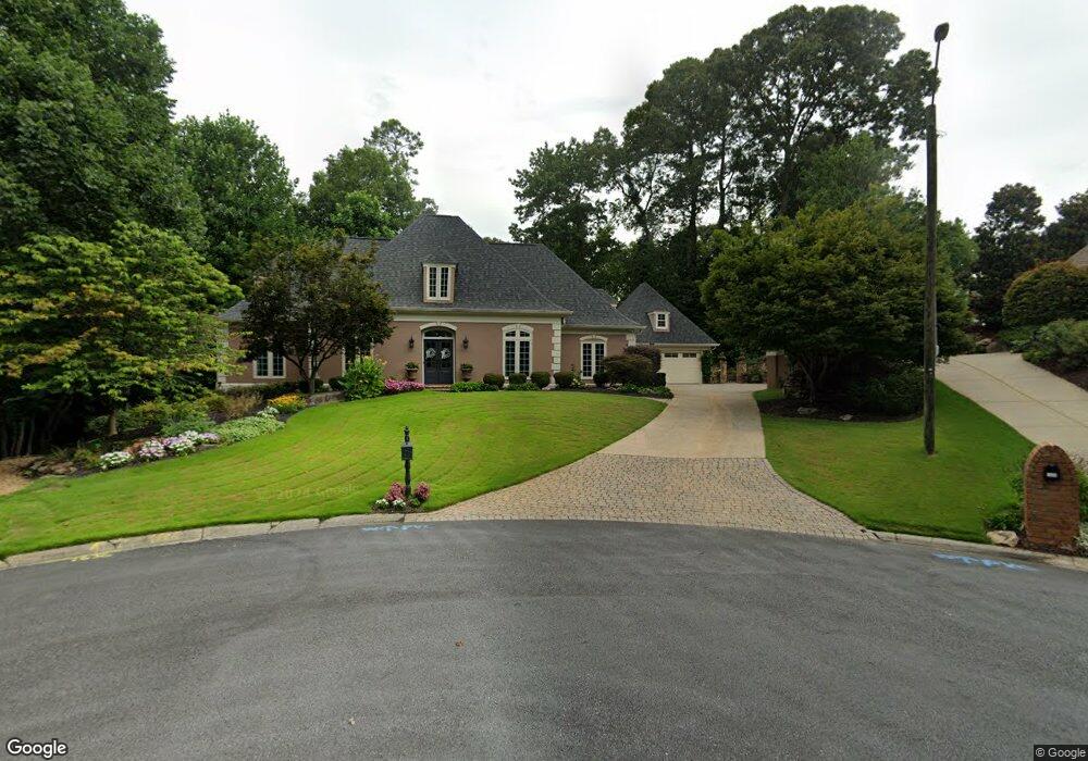
1636 Flyway Dr Marietta, GA 30068
East Cobb NeighborhoodEstimated Value: $822,000 - $915,000
4
Beds
4
Baths
2,848
Sq Ft
$302/Sq Ft
Est. Value
About This Home
This home is located at 1636 Flyway Dr, Marietta, GA 30068 and is currently estimated at $859,590, approximately $301 per square foot. 1636 Flyway Dr is a home located in Cobb County with nearby schools including Timber Ridge Elementary School, Dickerson Middle School, and Walton High School.
Ownership History
Date
Name
Owned For
Owner Type
Purchase Details
Closed on
Jan 29, 1999
Sold by
Upton Denise T
Bought by
Knapp Douglas R and Knapp Lynne A
Current Estimated Value
Home Financials for this Owner
Home Financials are based on the most recent Mortgage that was taken out on this home.
Original Mortgage
$236,000
Outstanding Balance
$55,163
Interest Rate
6.85%
Mortgage Type
New Conventional
Estimated Equity
$804,427
Create a Home Valuation Report for This Property
The Home Valuation Report is an in-depth analysis detailing your home's value as well as a comparison with similar homes in the area
Home Values in the Area
Average Home Value in this Area
Purchase History
| Date | Buyer | Sale Price | Title Company |
|---|---|---|---|
| Knapp Douglas R | $315,000 | -- |
Source: Public Records
Mortgage History
| Date | Status | Borrower | Loan Amount |
|---|---|---|---|
| Open | Knapp Douglas R | $236,000 |
Source: Public Records
Tax History Compared to Growth
Tax History
| Year | Tax Paid | Tax Assessment Tax Assessment Total Assessment is a certain percentage of the fair market value that is determined by local assessors to be the total taxable value of land and additions on the property. | Land | Improvement |
|---|---|---|---|---|
| 2025 | $1,624 | $286,208 | $72,000 | $214,208 |
| 2024 | $1,630 | $286,208 | $72,000 | $214,208 |
| 2023 | $1,274 | $236,200 | $52,000 | $184,200 |
| 2022 | $1,480 | $236,200 | $52,000 | $184,200 |
| 2021 | $1,480 | $236,200 | $52,000 | $184,200 |
| 2020 | $1,432 | $219,892 | $48,000 | $171,892 |
| 2019 | $5,398 | $219,892 | $48,000 | $171,892 |
| 2018 | $5,398 | $219,892 | $48,000 | $171,892 |
| 2017 | $4,607 | $189,952 | $44,000 | $145,952 |
| 2016 | $4,616 | $189,952 | $44,000 | $145,952 |
| 2015 | $4,453 | $178,616 | $36,000 | $142,616 |
| 2014 | $3,946 | $154,792 | $0 | $0 |
Source: Public Records
Map
Nearby Homes
- 4871 Karls Gate Dr
- 1804 Shelburne Ridge
- 5122 Timber Ridge Rd
- 1961 Fields Pond Dr
- 5140 Timber Ridge Rd
- 4599 Lasalle Ct Unit 8A
- 1720 Little Willeo Rd
- 5150 Timber Ridge Rd
- 4789 Waterhaven Bend
- 2066 Old Forge Way
- 4780 Waterhaven Bend
- 1929 Fields Pond Glen
- 2082 Kinsmon Dr
- 4580 Roswell Rd
- 1525 Huntingford Dr
- 1420 Lafayette Ln
- 5184 Deering Trail Unit 2
- 1634 Flyway Dr
- 1845 Mallard Lake Dr
- 1845 Mallard Lake Dr Unit 1
- 1637 Flyway Dr
- 1623 Pintail Point
- 1621 Pintail Point
- 1843 Mallard Lake Dr
- 1839 Mallard Lake Dr
- 1635 Flyway Dr
- 1632 Flyway Dr
- 1837 Mallard Lake Dr
- 1841 Mallard Lake Dr
- 0 Pintail Point Unit 3155064
- 1624 Pintail Point
- 1622 Pintail Point
- 1633 Flyway Dr
- 1835 Mallard Lake Dr
- 1620 Pintail Point
- 1848 Mallard Lake Dr
- 1838 Mallard Lake Dr