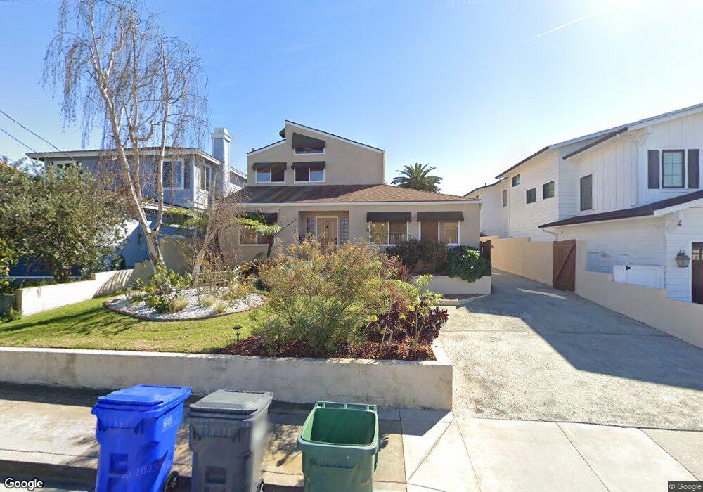
1636 Voorhees Ave Manhattan Beach, CA 90266
Estimated Value: $2,307,000 - $3,326,000
3
Beds
3
Baths
2,494
Sq Ft
$1,092/Sq Ft
Est. Value
About This Home
This home is located at 1636 Voorhees Ave, Manhattan Beach, CA 90266 and is currently estimated at $2,723,024, approximately $1,091 per square foot. 1636 Voorhees Ave is a home located in Los Angeles County with nearby schools including Aurelia Pennekamp Elementary School, Manhattan Beach Middle School, and Mira Costa High School.
Ownership History
Date
Name
Owned For
Owner Type
Purchase Details
Closed on
Jun 30, 2020
Sold by
Kintis Mark
Bought by
Kintis Mark and Vankintis Tuongvi Van
Current Estimated Value
Purchase Details
Closed on
Feb 21, 2001
Sold by
Kintis Mark
Bought by
Kintis Mark
Home Financials for this Owner
Home Financials are based on the most recent Mortgage that was taken out on this home.
Original Mortgage
$337,000
Interest Rate
6.98%
Create a Home Valuation Report for This Property
The Home Valuation Report is an in-depth analysis detailing your home's value as well as a comparison with similar homes in the area
Home Values in the Area
Average Home Value in this Area
Purchase History
We collect this data history from publicly available records. To have your information removed, we recommend requesting removal directly through your county’s website.
| Date | Buyer | Sale Price | Title Company |
|---|---|---|---|
| Kintis Mark | -- | None Available | |
| Kintis Mark | -- | Fidelity Title |
Source: Public Records
Mortgage History
We collect this data history from publicly available records. To have your information removed, we recommend requesting removal directly through your county’s website.
| Date | Status | Borrower | Loan Amount |
|---|---|---|---|
| Closed | Kintis Mark | $337,000 |
Source: Public Records
Tax History
| Year | Tax Paid | Tax Assessment Tax Assessment Total Assessment is a certain percentage of the fair market value that is determined by local assessors to be the total taxable value of land and additions on the property. | Land | Improvement |
|---|---|---|---|---|
| 2025 | $11,653 | $974,261 | $739,032 | $235,229 |
| 2024 | $11,495 | $955,159 | $724,542 | $230,617 |
| 2023 | $11,032 | $936,432 | $710,336 | $226,096 |
| 2022 | $10,847 | $918,071 | $696,408 | $221,663 |
| 2021 | $10,691 | $900,070 | $682,753 | $217,317 |
| 2019 | $10,411 | $873,375 | $662,503 | $210,872 |
| 2018 | $10,110 | $856,251 | $649,513 | $206,738 |
| 2016 | $9,272 | $823,004 | $624,293 | $198,711 |
| 2015 | $9,082 | $810,643 | $614,916 | $195,727 |
| 2014 | $8,963 | $794,764 | $602,871 | $191,893 |
Source: Public Records
Map
Nearby Homes
- 1612 Gates Ave
- 1756 Voorhees Ave
- 1756 Ruhland Ave
- 217 S Aviation Blvd
- 207 S Aviation Blvd
- 1907 Voorhees Ave
- 1744 Wollacott St
- 1500 2nd St
- 1911 Curtis Ave Unit A
- 1742 Reed St
- 1917 Nelson Ave Unit E
- 1725 Axenty Way
- 1346 Gates Ave
- 1923 Gates Ave
- 1925 Gates Ave
- 1924 Mathews Ave Unit C
- 1307 Curtis Ave
- 2005 Mathews Ave Unit B
- 1806 6th St
- 2013 Ruhland Ave
- 1626 Voorhees Ave
- 1632 Voorhees Ave
- 1622 Voorhees Ave
- 1616 Voorhees Ave
- 1642 Voorhees Ave
- 1627 Ruhland Ave
- 1612 Voorhees Ave
- 1623 Ruhland Ave
- 1633 Ruhland Ave
- 1617 Ruhland Ave
- 1637 Ruhland Ave
- 1627 Voorhees Ave
- 1633 Voorhees Ave
- 1623 Voorhees Ave
- 1646 Voorhees Ave
- 1606 Voorhees Ave
- 1613 Ruhland Ave
- 1643 Ruhland Ave
- 1637 Voorhees Ave
- 1617 Voorhees Ave
Your Personal Tour Guide
Ask me questions while you tour the home.