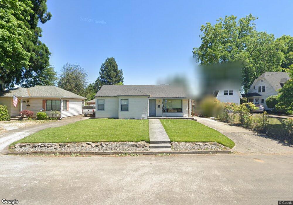
1637 Hawthorne St Forest Grove, OR 97116
Estimated Value: $437,000 - $489,000
3
Beds
2
Baths
1,552
Sq Ft
$302/Sq Ft
Est. Value
About This Home
This home is located at 1637 Hawthorne St, Forest Grove, OR 97116 and is currently estimated at $469,042, approximately $302 per square foot. 1637 Hawthorne St is a home located in Washington County with nearby schools including Joseph Gale Elementary School, Tom McCall Upper Elementary School, and Neil Armstrong Middle School.
Ownership History
Date
Name
Owned For
Owner Type
Purchase Details
Closed on
Apr 11, 2022
Sold by
Davis Pamela S
Bought by
Davis Pamela S and Davis Glynn
Current Estimated Value
Purchase Details
Closed on
Jun 25, 2007
Sold by
Anderson David S
Bought by
Anderson David S and Anderson Pamela L
Home Financials for this Owner
Home Financials are based on the most recent Mortgage that was taken out on this home.
Original Mortgage
$138,000
Interest Rate
6.21%
Mortgage Type
New Conventional
Create a Home Valuation Report for This Property
The Home Valuation Report is an in-depth analysis detailing your home's value as well as a comparison with similar homes in the area
Home Values in the Area
Average Home Value in this Area
Purchase History
| Date | Buyer | Sale Price | Title Company |
|---|---|---|---|
| Davis Pamela S | -- | None Listed On Document | |
| Anderson David S | -- | First American |
Source: Public Records
Mortgage History
| Date | Status | Borrower | Loan Amount |
|---|---|---|---|
| Previous Owner | Anderson David S | $138,000 |
Source: Public Records
Tax History Compared to Growth
Tax History
| Year | Tax Paid | Tax Assessment Tax Assessment Total Assessment is a certain percentage of the fair market value that is determined by local assessors to be the total taxable value of land and additions on the property. | Land | Improvement |
|---|---|---|---|---|
| 2026 | $3,686 | $207,000 | -- | -- |
| 2025 | $3,686 | $200,980 | -- | -- |
| 2024 | $3,556 | $195,130 | -- | -- |
| 2023 | $3,556 | $189,450 | $0 | $0 |
| 2022 | $3,110 | $189,450 | $0 | $0 |
| 2021 | $3,069 | $178,590 | $0 | $0 |
| 2020 | $3,053 | $173,390 | $0 | $0 |
| 2019 | $2,985 | $168,340 | $0 | $0 |
| 2018 | $2,893 | $163,440 | $0 | $0 |
| 2017 | $2,804 | $158,680 | $0 | $0 |
| 2016 | $2,725 | $154,060 | $0 | $0 |
| 2015 | $2,620 | $149,580 | $0 | $0 |
| 2014 | $2,608 | $145,230 | $0 | $0 |
Source: Public Records
Map
Nearby Homes
- 2743 15th Place
- 0 Crescent Dr
- 2815 18th Ave
- 1822 Hawthorne St
- 1813 Filbert St
- 1615 Kingwood St
- 2824 19th Ave
- 2902 19th Ave
- 1118 Hampton Ct
- 1119 Hawthorne St
- 3128 Brittany Dr
- 2323 19th Ave
- 3213 Maple Place
- 2220 17th Ave
- 2828 22nd Ave Unit 3
- 2828 22nd Ave Unit 5
- 0 Kingwood St
- 3404 19th Ave Unit 103
- 3404 19th Ave Unit 215
- 2032 18th Ave
- 1643 Hawthorne St
- 1629 Hawthorne St
- 1620 Lynwood Dr
- 1651 Hawthorne St
- 1621 Hawthorne St
- 1628 Lynwood Dr
- 2714 17th Ave
- 1638 Hawthorne St
- 1626 Hawthorne St
- 1644 Hawthorne St
- 1650 Hawthorne St
- 1617 Hawthorne St
- 1608 Lynwood Dr
- 2718 17th Ave
- 1632 Hawthorne St
- 1628 Hawthorne St
- 2634 17th Ave
- 2732 17th Ave
- 1624 Hawthorne St
- 1607 Hawthorne St