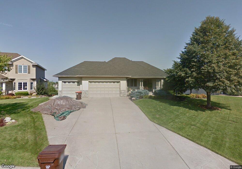
1640 Stonegate Ct Hastings, MN 55033
Hastings-Marshan Township NeighborhoodEstimated Value: $534,000 - $606,000
4
Beds
4
Baths
1,560
Sq Ft
$363/Sq Ft
Est. Value
About This Home
This home is located at 1640 Stonegate Ct, Hastings, MN 55033 and is currently estimated at $566,486, approximately $363 per square foot. 1640 Stonegate Ct is a home located in Dakota County with nearby schools including Christa Mcauliffe Elementary School, Hastings Middle School, and Hastings High School.
Ownership History
Date
Name
Owned For
Owner Type
Purchase Details
Closed on
Dec 10, 2015
Sold by
Thompson Jeffrey A and Thompson Ann M
Bought by
Us Bank National Association
Current Estimated Value
Purchase Details
Closed on
Mar 1, 1999
Sold by
Graus Builders Inc
Bought by
Thompson Jeffrey A and Thompson Ann M
Purchase Details
Closed on
Jun 18, 1998
Sold by
Wallin Ltd Partnership
Bought by
Graus Builders Inc
Create a Home Valuation Report for This Property
The Home Valuation Report is an in-depth analysis detailing your home's value as well as a comparison with similar homes in the area
Home Values in the Area
Average Home Value in this Area
Purchase History
| Date | Buyer | Sale Price | Title Company |
|---|---|---|---|
| Us Bank National Association | $206,409 | None Available | |
| Thompson Jeffrey A | $225,000 | -- | |
| Graus Builders Inc | $43,900 | -- |
Source: Public Records
Tax History Compared to Growth
Tax History
| Year | Tax Paid | Tax Assessment Tax Assessment Total Assessment is a certain percentage of the fair market value that is determined by local assessors to be the total taxable value of land and additions on the property. | Land | Improvement |
|---|---|---|---|---|
| 2024 | $6,028 | $529,600 | $139,200 | $390,400 |
| 2023 | $6,028 | $518,200 | $139,300 | $378,900 |
| 2022 | $5,156 | $505,000 | $139,100 | $365,900 |
| 2021 | $4,822 | $418,700 | $121,000 | $297,700 |
| 2020 | $5,006 | $388,800 | $107,400 | $281,400 |
| 2019 | $4,893 | $390,100 | $102,300 | $287,800 |
| 2018 | $4,939 | $361,800 | $97,400 | $264,400 |
| 2017 | $4,568 | $352,800 | $92,800 | $260,000 |
| 2016 | $4,655 | $330,800 | $86,700 | $244,100 |
| 2015 | $4,584 | $320,934 | $82,138 | $238,796 |
| 2014 | -- | $317,773 | $79,029 | $238,744 |
| 2013 | -- | $280,277 | $70,526 | $209,751 |
Source: Public Records
Map
Nearby Homes
- 1796 Cobblestone Ct
- 1797 Cobblestone Ct
- 1757 Brandlewood Ct
- Alley Plan at Heritage Ridge
- Alley Plan at Heritage Ridge - Villas
- Kenny Plan at Heritage Ridge - Villas
- Sully Plan at Heritage Ridge - Villas
- Henry Plan at Heritage Ridge - Villas
- Riley Plan at Heritage Ridge - Villas
- Victoria Plan at Heritage Ridge - Villas
- Hudson Plan at Heritage Ridge - Villas
- Ashlyn Plan at Heritage Ridge - Villas
- Arlow Plan at Heritage Ridge - Villas
- Hudson Plan at Heritage Ridge
- Ashlyn Plan at Heritage Ridge
- Nora Plan at Heritage Ridge
- Arlow Plan at Heritage Ridge
- 1821 Fallbrooke Dr
- 1817 Ridgepointe Ct
- 1824 Fallbrooke Dr
- 1620 Stonegate Ct
- 1660 Stonegate Ct
- 1600 Stonegate Ct
- 1680 Stonegate Ct
- 1621 Stonegate Ct
- 1681 Stonegate Ct
- 1661 Stonegate Ct
- 1601 Stonegate Ct
- 1607 Northridge Dr
- 1590 Stonegate Rd
- 1610 Northridge Dr
- 1589 Stonegate Rd
- 1734 Fallbrooke Dr
- 1620 1620 Northridge Dr
- 1620 Northridge Dr
- 1605 Northridge Dr
- 1726 1726 Fallbrooke Dr
- 1726 Fallbrooke Dr
- 1582 Stonegate Rd
- 1630 Northridge Dr