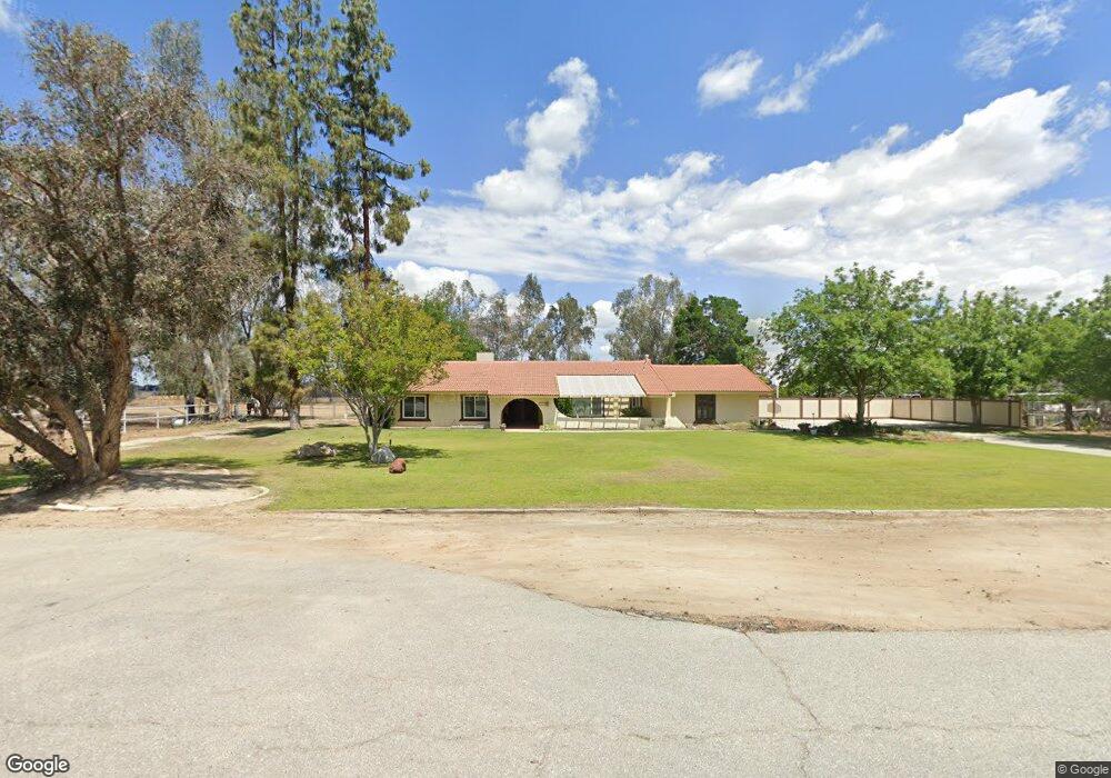
16420 Becky Ave Bakersfield, CA 93314
Estimated Value: $570,000 - $646,857
3
Beds
3
Baths
1,696
Sq Ft
$360/Sq Ft
Est. Value
About This Home
This home is located at 16420 Becky Ave, Bakersfield, CA 93314 and is currently estimated at $609,964, approximately $359 per square foot. 16420 Becky Ave is a home located in Kern County with nearby schools including Independence Elementary School, Freedom Middle School, and Frontier High School.
Ownership History
Date
Name
Owned For
Owner Type
Purchase Details
Closed on
Oct 3, 2024
Sold by
Gorman Timothy D and Gorman Debra Lynne
Bought by
Gorman Family Trust and Gorman
Current Estimated Value
Purchase Details
Closed on
May 3, 2023
Sold by
P & A Santer Family Revocable Trust
Bought by
Gorman Debra Lynn and Gorman Timothy D
Home Financials for this Owner
Home Financials are based on the most recent Mortgage that was taken out on this home.
Original Mortgage
$360,000
Interest Rate
5.64%
Mortgage Type
New Conventional
Purchase Details
Closed on
Jul 12, 2012
Sold by
Santer Peter F and Santer Anne B
Bought by
Santer Peter F
Create a Home Valuation Report for This Property
The Home Valuation Report is an in-depth analysis detailing your home's value as well as a comparison with similar homes in the area
Home Values in the Area
Average Home Value in this Area
Purchase History
| Date | Buyer | Sale Price | Title Company |
|---|---|---|---|
| Gorman Family Trust | -- | None Listed On Document | |
| Gorman Debra Lynn | $520,000 | Lawyers Title Company | |
| Santer Peter F | -- | None Available |
Source: Public Records
Mortgage History
| Date | Status | Borrower | Loan Amount |
|---|---|---|---|
| Previous Owner | Gorman Debra Lynn | $360,000 |
Source: Public Records
Tax History Compared to Growth
Tax History
| Year | Tax Paid | Tax Assessment Tax Assessment Total Assessment is a certain percentage of the fair market value that is determined by local assessors to be the total taxable value of land and additions on the property. | Land | Improvement |
|---|---|---|---|---|
| 2025 | $6,795 | $541,008 | $312,120 | $228,888 |
| 2024 | $4,574 | $530,400 | $306,000 | $224,400 |
| 2023 | $4,574 | $339,909 | $110,464 | $229,445 |
| 2022 | $4,473 | $333,246 | $108,299 | $224,947 |
| 2021 | $4,299 | $326,713 | $106,176 | $220,537 |
| 2020 | $4,172 | $323,364 | $105,088 | $218,276 |
| 2019 | $4,050 | $323,364 | $105,088 | $218,276 |
| 2018 | $3,942 | $310,809 | $101,008 | $209,801 |
| 2017 | $3,829 | $304,716 | $99,028 | $205,688 |
| 2016 | $3,593 | $298,742 | $97,087 | $201,655 |
| 2015 | $3,483 | $294,255 | $95,629 | $198,626 |
| 2014 | $3,404 | $288,492 | $93,756 | $194,736 |
Source: Public Records
Map
Nearby Homes
- 16612 Bellewood Place
- 16725 Bellewood Place
- 4104 Woodcastle Way
- 16617 Stone Mill Ct
- 3128 Cavalcade Way
- 16602 Northfield Way
- 15915 Quintero Place
- 16009 La Strada Ct
- 16716 Brookview Ct
- 16741 Pinecrest Ct
- 15726 Saint Clement Way
- 15527 Avanti Dr
- 15525 Calabria Ct
- 15414 Quintero Place
- 16727 Brookview Ct
- 14924 Wayne Lee Ct
- 16746 Starview Ct
- 14925 Wayne Lee Ct
- 2539 Marva Marie Ct
- 3139 Nord Ave
- 16310 Becky Ave
- 16600 Weatherly Ct
- 16449 Becky Ave
- 16421 Winfield Ave
- 16327 Becky Ave
- 16607 Manor View Ct
- 16351 Winfield Ave
- 16602 Keystone Place
- 16212 Becky Ave
- 16350 Meacham Rd
- 16249 Winfield Ave
- 16618 Manor View Ct
- 16601 Bellewood Place
- 3900 Woodcastle Way
- 16250 Meacham Rd
- 16609 Bellewood Place
- 16149 Becky Ave
- 16626 Manor View Ct
- 16130 Becky Ave
- 3908 Woodcastle Way