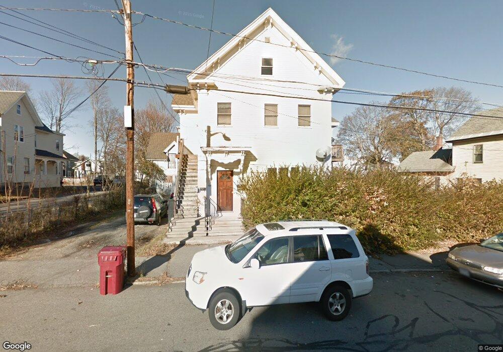
165 Branch St Lowell, MA 01851
Lower Highlands NeighborhoodEstimated Value: $648,703 - $732,000
4
Beds
2
Baths
3,673
Sq Ft
$189/Sq Ft
Est. Value
About This Home
This home is located at 165 Branch St, Lowell, MA 01851 and is currently estimated at $694,926, approximately $189 per square foot. 165 Branch St is a home located in Middlesex County with nearby schools including Charles W. Morey Elementary School, Abraham Lincoln Elementary School, and Charlotte M. Murkland Elementary School.
Ownership History
Date
Name
Owned For
Owner Type
Purchase Details
Closed on
Dec 22, 2017
Sold by
Reg Rt 3 and Guarino
Bought by
Gre Realty Management
Current Estimated Value
Purchase Details
Closed on
Mar 31, 2008
Sold by
Touliopoulos Rose
Bought by
Reg Rt and Guarino
Create a Home Valuation Report for This Property
The Home Valuation Report is an in-depth analysis detailing your home's value as well as a comparison with similar homes in the area
Home Values in the Area
Average Home Value in this Area
Purchase History
| Date | Buyer | Sale Price | Title Company |
|---|---|---|---|
| Gre Realty Management | -- | -- | |
| Gre Realty Management | -- | -- | |
| Reg Rt | $233,000 | -- | |
| Reg Rt | $233,000 | -- |
Source: Public Records
Mortgage History
| Date | Status | Borrower | Loan Amount |
|---|---|---|---|
| Previous Owner | Reg Rt | $800,000 |
Source: Public Records
Tax History
| Year | Tax Paid | Tax Assessment Tax Assessment Total Assessment is a certain percentage of the fair market value that is determined by local assessors to be the total taxable value of land and additions on the property. | Land | Improvement |
|---|---|---|---|---|
| 2025 | $7,278 | $634,000 | $189,800 | $444,200 |
| 2024 | $6,709 | $563,300 | $170,700 | $392,600 |
| 2023 | $6,164 | $496,300 | $148,400 | $347,900 |
| 2022 | $5,705 | $449,600 | $134,900 | $314,700 |
| 2021 | $5,288 | $392,900 | $117,400 | $275,500 |
| 2020 | $4,764 | $356,600 | $102,600 | $254,000 |
| 2019 | $4,289 | $305,500 | $95,000 | $210,500 |
| 2018 | $4,777 | $274,900 | $86,400 | $188,500 |
| 2017 | $3,740 | $250,700 | $78,600 | $172,100 |
| 2016 | $3,751 | $247,400 | $74,800 | $172,600 |
| 2015 | $3,517 | $227,200 | $76,600 | $150,600 |
| 2013 | $3,334 | $222,100 | $91,500 | $130,600 |
Source: Public Records
Map
Nearby Homes
- 19 Lawton St
- 3 Butman Place
- 42 Branch St
- 312 Wilder St
- 68 Smith St
- 143 Westford St
- 11 Warwick St Unit 3
- 45 Marshall St
- 49 Marginal St
- 137 Pine St Unit 11
- 18 Burgess St
- 15 Barclay St
- 17 Edson St
- 45 Harvard St Unit 5 3rd fl
- 710 School St
- 491 Dutton St Unit 305
- 491 Dutton St Unit 409
- 491 Dutton St Unit 504
- 57 Wannalancit St Unit 6
- 57 Wannalancit St Unit 11
- 155 Branch St
- 35 Maude St Unit 3
- 173 Branch St
- 27 Maude St
- 27 Maude St Unit 3
- 27 Maude St Unit 1
- 24 Maude St
- 151 Branch St
- 162 Branch St
- 29 Maude St Unit 2nd floor
- 179 Branch St
- 145 Branch St
- 166 Branch St
- 152 Branch St
- 172 Branch St
- 16 Maude St
- 176 Branch St
- 15 Walker Place
- 13 Walker Place
- 15 Walker Place Unit 15
Your Personal Tour Guide
Ask me questions while you tour the home.