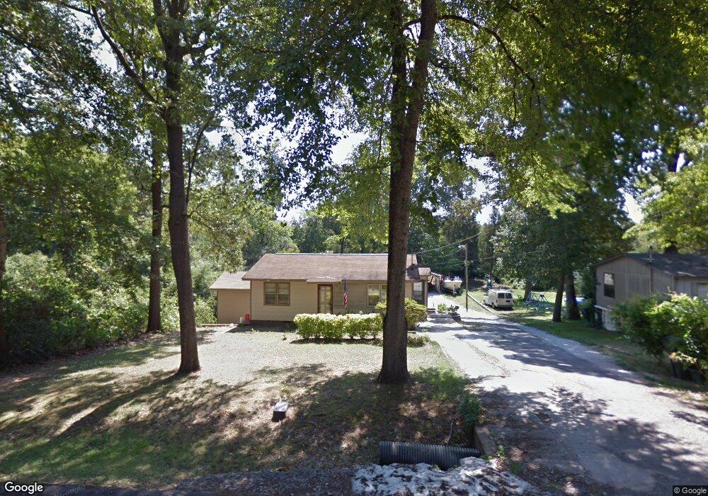
165 Carter Cir Warner Robins, GA 31093
Estimated Value: $93,527 - $137,000
2
Beds
2
Baths
816
Sq Ft
$144/Sq Ft
Est. Value
About This Home
This home is located at 165 Carter Cir, Warner Robins, GA 31093 and is currently estimated at $117,632, approximately $144 per square foot. 165 Carter Cir is a home located in Houston County with nearby schools including Westside Elementary School, Northside Middle School, and Northside High School.
Ownership History
Date
Name
Owned For
Owner Type
Purchase Details
Closed on
Jun 9, 2022
Sold by
Warnock Larry E
Bought by
Stencel Anthony M and Stencel Cynthia D
Current Estimated Value
Purchase Details
Closed on
Dec 16, 1988
Sold by
Levins Edward E
Bought by
Stencel Anthony M and Cynthia D*
Purchase Details
Closed on
Oct 16, 1986
Sold by
Levins Lena Mae Bateman
Bought by
Levins Edward E
Purchase Details
Closed on
Oct 14, 1961
Bought by
Levins Lena Mae B
Create a Home Valuation Report for This Property
The Home Valuation Report is an in-depth analysis detailing your home's value as well as a comparison with similar homes in the area
Home Values in the Area
Average Home Value in this Area
Purchase History
| Date | Buyer | Sale Price | Title Company |
|---|---|---|---|
| Stencel Anthony M | $9,000 | Moore Law Firm Llc | |
| Stencel Anthony M | $40,000 | -- | |
| Levins Edward E | -- | -- | |
| Levins Lena Mae B | -- | -- |
Source: Public Records
Tax History Compared to Growth
Tax History
| Year | Tax Paid | Tax Assessment Tax Assessment Total Assessment is a certain percentage of the fair market value that is determined by local assessors to be the total taxable value of land and additions on the property. | Land | Improvement |
|---|---|---|---|---|
| 2024 | $541 | $24,600 | $6,200 | $18,400 |
| 2023 | $411 | $19,000 | $3,280 | $15,720 |
| 2022 | $383 | $17,840 | $3,280 | $14,560 |
| 2021 | $332 | $15,680 | $3,280 | $12,400 |
| 2020 | $384 | $15,680 | $3,280 | $12,400 |
| 2019 | $334 | $15,680 | $3,280 | $12,400 |
| 2018 | $334 | $15,680 | $3,280 | $12,400 |
| 2017 | $334 | $15,680 | $3,280 | $12,400 |
| 2016 | $335 | $15,680 | $3,280 | $12,400 |
| 2015 | $335 | $15,680 | $3,280 | $12,400 |
| 2014 | -- | $15,680 | $3,280 | $12,400 |
| 2013 | -- | $18,472 | $3,280 | $15,192 |
Source: Public Records
Map
Nearby Homes
- 209 Knodishall Dr
- 129 Maryjay Dr
- 111 Hawthorne Rd
- 501 Pinecrest Dr
- 301 Millside Dr
- 112 Peacock Dr
- 110 Westcliff Cir Unit C
- 106 Westcliff Cir
- 221 Gilchrist Dr
- 725 B East Side Dr
- 103 Westcliff Cir Unit A
- 103 Westcliff Cir Unit A
- 303 Pinecrest Dr
- 141 Peacock Dr
- 318 Somerset Dr
- 86 Westcliff Cir
- 102 Westcliff Center St Unit D
- 110 Westcliff Center St
- 321 Somerset Dr
- 115 Wray St
- 167 Carter Cir
- 169 Carter Cir
- 171 Carter Cir
- 127 Carter Cir
- 166 Carter Cir
- 168 Carter Cir
- 164 Carter Cir
- 164 Carter Cir
- 121 Carter Cir
- 121 Carter Cir Unit 123 Carter Circle
- 173 Carter Cir
- 129 Carter Cir
- 170 Carter Cir
- 160 Carter Cir
- 120 Carter Cir
- 155 Carter Cir
- 174 Carter Cir
- 0 Carter Cir Unit LOT 34 OAKVIEW 139/5
- 0 Carter Cir Unit 7250382
- 0 Carter Cir Unit 8755617