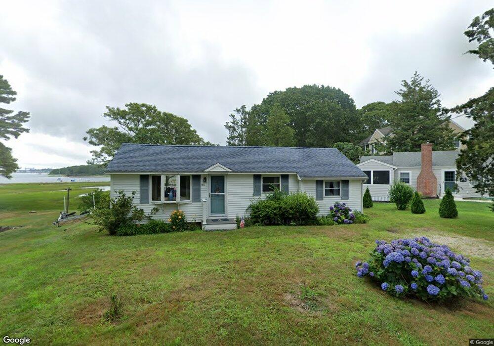
165 Tahanto Rd Pocasset, MA 02559
Pocasset NeighborhoodEstimated Value: $659,000 - $755,000
2
Beds
1
Bath
885
Sq Ft
$813/Sq Ft
Est. Value
About This Home
This home is located at 165 Tahanto Rd, Pocasset, MA 02559 and is currently estimated at $719,323, approximately $812 per square foot. 165 Tahanto Rd is a home located in Barnstable County with nearby schools including Bourne High School, Cadence Academy Preschool - Bourne, and St Margaret Regional School.
Ownership History
Date
Name
Owned For
Owner Type
Purchase Details
Closed on
May 27, 1997
Sold by
Hutchinson Susan D
Bought by
Feeney Kenneth P and Feeney Christina M
Current Estimated Value
Home Financials for this Owner
Home Financials are based on the most recent Mortgage that was taken out on this home.
Original Mortgage
$105,200
Outstanding Balance
$15,184
Interest Rate
8.08%
Mortgage Type
Purchase Money Mortgage
Estimated Equity
$704,139
Create a Home Valuation Report for This Property
The Home Valuation Report is an in-depth analysis detailing your home's value as well as a comparison with similar homes in the area
Home Values in the Area
Average Home Value in this Area
Purchase History
| Date | Buyer | Sale Price | Title Company |
|---|---|---|---|
| Feeney Kenneth P | $131,500 | -- | |
| Feeney Kenneth P | $131,500 | -- |
Source: Public Records
Mortgage History
| Date | Status | Borrower | Loan Amount |
|---|---|---|---|
| Open | Feeney Kenneth P | $105,200 | |
| Closed | Feeney Kenneth P | $105,200 |
Source: Public Records
Tax History Compared to Growth
Tax History
| Year | Tax Paid | Tax Assessment Tax Assessment Total Assessment is a certain percentage of the fair market value that is determined by local assessors to be the total taxable value of land and additions on the property. | Land | Improvement |
|---|---|---|---|---|
| 2025 | $5,202 | $666,100 | $511,100 | $155,000 |
| 2024 | $5,088 | $634,400 | $486,800 | $147,600 |
| 2023 | $4,947 | $561,500 | $430,800 | $130,700 |
| 2022 | $4,893 | $484,900 | $381,200 | $103,700 |
| 2021 | $4,754 | $441,400 | $347,000 | $94,400 |
| 2020 | $4,651 | $433,100 | $343,700 | $89,400 |
| 2019 | $2,584 | $428,100 | $343,700 | $84,400 |
| 2018 | $4,253 | $403,500 | $327,300 | $76,200 |
| 2017 | $4,017 | $390,000 | $324,200 | $65,800 |
| 2016 | $3,949 | $388,700 | $324,200 | $64,500 |
| 2015 | $3,697 | $367,100 | $302,600 | $64,500 |
Source: Public Records
Map
Nearby Homes
- 161 Tahanto Rd
- 169 Tahanto Rd
- 2 Navajo Rd
- 158 Tahanto Rd
- 173 Tahanto Rd
- 179 Tahanto Rd
- 66 King Phillip Rd
- 162 Tahanto Rd
- 154 Tahanto Rd
- 6 Navajo Rd
- 181 Tahanto Rd
- 65 King Phillip Rd
- 168 Tahanto Rd
- 157 Tahanto Rd
- 62 King Phillip Rd
- 10 Navajo Rd
- 50 Pocahontas Rd
- 174 Tahanto Rd
- 183 Tahanto Rd
- 10 Wabenaki Rd