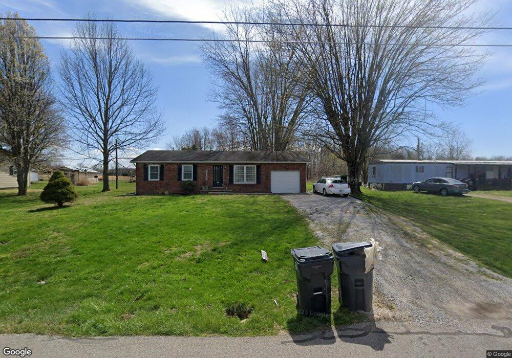
165 W Harrod Rd Austin, IN 47102
Estimated Value: $155,000 - $176,000
3
Beds
1
Bath
1,040
Sq Ft
$158/Sq Ft
Est. Value
About This Home
This home is located at 165 W Harrod Rd, Austin, IN 47102 and is currently estimated at $164,307, approximately $157 per square foot. 165 W Harrod Rd is a home located in Scott County with nearby schools including Austin Elementary School, Austin Middle School, and Austin High School.
Ownership History
Date
Name
Owned For
Owner Type
Purchase Details
Closed on
Jul 22, 2020
Sold by
Mahan Melissa A and Estate Mary Mcintosh
Bought by
Bratton Wesley and Bratton Faith E
Current Estimated Value
Home Financials for this Owner
Home Financials are based on the most recent Mortgage that was taken out on this home.
Original Mortgage
$66,750
Outstanding Balance
$59,299
Interest Rate
3.2%
Mortgage Type
Commercial
Estimated Equity
$105,008
Create a Home Valuation Report for This Property
The Home Valuation Report is an in-depth analysis detailing your home's value as well as a comparison with similar homes in the area
Home Values in the Area
Average Home Value in this Area
Purchase History
| Date | Buyer | Sale Price | Title Company |
|---|---|---|---|
| Bratton Wesley | -- | None Available |
Source: Public Records
Mortgage History
| Date | Status | Borrower | Loan Amount |
|---|---|---|---|
| Open | Bratton Wesley | $66,750 |
Source: Public Records
Tax History Compared to Growth
Tax History
| Year | Tax Paid | Tax Assessment Tax Assessment Total Assessment is a certain percentage of the fair market value that is determined by local assessors to be the total taxable value of land and additions on the property. | Land | Improvement |
|---|---|---|---|---|
| 2024 | $428 | $73,600 | $12,200 | $61,400 |
| 2023 | $451 | $77,700 | $12,200 | $65,500 |
| 2022 | $382 | $78,600 | $12,200 | $66,400 |
| 2021 | $332 | $73,100 | $12,200 | $60,900 |
| 2020 | $407 | $77,600 | $12,200 | $65,400 |
| 2019 | $39 | $74,600 | $12,200 | $62,400 |
| 2018 | $51 | $72,600 | $9,900 | $62,700 |
| 2017 | $47 | $72,500 | $9,900 | $62,600 |
| 2016 | $47 | $71,800 | $9,900 | $61,900 |
| 2014 | $46 | $66,400 | $9,900 | $56,500 |
| 2013 | $46 | $66,400 | $9,900 | $56,500 |
Source: Public Records
Map
Nearby Homes
- 92 Stonybrook Dr
- 0 County Road 650 N
- 1212 Mann Ave
- 1153 Clay St
- 1105 Pearl St
- 746 Goodin Dr
- 748 Goodin Dr
- 6897 N Bogardus Rd
- 0 E Crothersville Rd Unit otWP001 23277874
- 0 E Crothersville Rd
- 1020 N Church St
- 96 Hill St
- 569 Broadway St
- 920 N 3rd St
- 41 Rural St
- 180 Broadway St
- 1671 Burns Ct
- 139 Factory Dr
- 60 Factory Dr
- 220 Mann Ave
- 177 W Harrod Rd
- 143 W Harrod Rd
- 131 W Harrod Rd
- 209 W Harrod Rd
- 124 W Harrod Rd
- 101 W Harrod Rd
- 81 W Harrod Rd
- 255 E Harrod Rd
- 162 W Harmony Ln
- 63 W Harrod Rd
- 45 W Harrod Rd
- 31 W Harrod Rd
- 5455 N Meridian Rd
- 5435 N Meridian Rd
- 5407 N Meridian Rd
- 0 E Harrod Rd
- 317 W Harrod Rd
- 5389 N Meridian Rd
- 5371 N Meridian Rd
- 145 W Harmony Ln