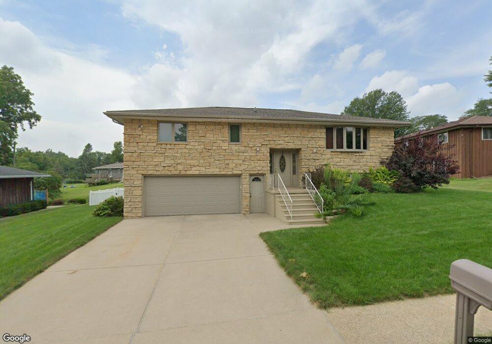
1650 Lori Ct Dubuque, IA 52001
Estimated Value: $288,709 - $320,000
3
Beds
4
Baths
1,380
Sq Ft
$218/Sq Ft
Est. Value
About This Home
This home is located at 1650 Lori Ct, Dubuque, IA 52001 and is currently estimated at $301,427, approximately $218 per square foot. 1650 Lori Ct is a home located in Dubuque County with nearby schools including Eisenhower Elementary School, Eleanor Roosevelt Middle School, and Dubuque Senior High School.
Ownership History
Date
Name
Owned For
Owner Type
Purchase Details
Closed on
Mar 29, 2024
Sold by
Avenarius Richard S and Avenarius Joyce A
Bought by
Flogel Davis and Klinger Leone
Current Estimated Value
Home Financials for this Owner
Home Financials are based on the most recent Mortgage that was taken out on this home.
Original Mortgage
$50,000
Interest Rate
1.2%
Mortgage Type
Seller Take Back
Create a Home Valuation Report for This Property
The Home Valuation Report is an in-depth analysis detailing your home's value as well as a comparison with similar homes in the area
Home Values in the Area
Average Home Value in this Area
Purchase History
| Date | Buyer | Sale Price | Title Company |
|---|---|---|---|
| Flogel Davis | $281,000 | None Listed On Document |
Source: Public Records
Mortgage History
| Date | Status | Borrower | Loan Amount |
|---|---|---|---|
| Closed | Flogel Davis | $50,000 | |
| Closed | Flogel Davis | $250,000 |
Source: Public Records
Tax History Compared to Growth
Tax History
| Year | Tax Paid | Tax Assessment Tax Assessment Total Assessment is a certain percentage of the fair market value that is determined by local assessors to be the total taxable value of land and additions on the property. | Land | Improvement |
|---|---|---|---|---|
| 2025 | $3,358 | $260,200 | $45,500 | $214,700 |
| 2024 | $3,358 | $243,700 | $41,300 | $202,400 |
| 2023 | $3,158 | $243,700 | $41,300 | $202,400 |
| 2022 | $3,124 | $197,800 | $37,210 | $160,590 |
| 2021 | $3,124 | $197,800 | $37,210 | $160,590 |
| 2020 | $3,022 | $178,770 | $35,140 | $143,630 |
| 2019 | $3,026 | $178,770 | $35,140 | $143,630 |
| 2018 | $2,976 | $171,280 | $33,070 | $138,210 |
| 2017 | $2,920 | $171,280 | $33,070 | $138,210 |
| 2016 | $2,856 | $159,680 | $33,070 | $126,610 |
| 2015 | $2,856 | $159,680 | $33,070 | $126,610 |
| 2014 | $2,732 | $157,200 | $33,070 | $124,130 |
Source: Public Records
Map
Nearby Homes
- 1930 Scenic View Dr
- 2347 Coventry Park Unit C-011
- 995 Kane St
- 0 Kaufmann Ave Unit 150494
- Lot 85 The Farm St
- 3112 Kaufmann Ave
- 800 Kane St
- 2095 Mullin Rd
- 2146 Avalon Rd
- 2290 Theda Dr
- 727 Berkley Place
- 1949 Saint Ambrose St
- 1896 Floraview Dr
- 2380 Trygg Dr
- 2887 Timberline St
- 2035 Broadlawn Rd
- 2560 Crissy Dr
- 2614 Crissy Dr
- 692 Kane St
- 1821 Glendale Ct