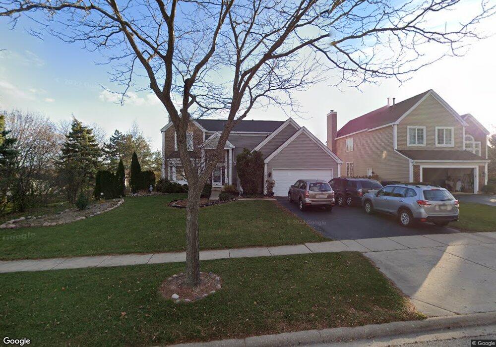
1653 Huntington Dr N Algonquin, IL 60102
Estimated Value: $427,595 - $493,000
4
Beds
3
Baths
2,302
Sq Ft
$203/Sq Ft
Est. Value
About This Home
This home is located at 1653 Huntington Dr N, Algonquin, IL 60102 and is currently estimated at $467,149, approximately $202 per square foot. 1653 Huntington Dr N is a home located in McHenry County with nearby schools including Westfield Community School, United Junior High School, and Harry D Jacobs High School.
Ownership History
Date
Name
Owned For
Owner Type
Purchase Details
Closed on
May 31, 1996
Sold by
Pulte Home Corp
Bought by
Roller John G and Roller Lisa M
Current Estimated Value
Home Financials for this Owner
Home Financials are based on the most recent Mortgage that was taken out on this home.
Original Mortgage
$150,100
Outstanding Balance
$9,581
Interest Rate
7.99%
Estimated Equity
$457,568
Create a Home Valuation Report for This Property
The Home Valuation Report is an in-depth analysis detailing your home's value as well as a comparison with similar homes in the area
Home Values in the Area
Average Home Value in this Area
Purchase History
| Date | Buyer | Sale Price | Title Company |
|---|---|---|---|
| Roller John G | $201,000 | -- |
Source: Public Records
Mortgage History
| Date | Status | Borrower | Loan Amount |
|---|---|---|---|
| Open | Roller John G | $150,100 |
Source: Public Records
Tax History Compared to Growth
Tax History
| Year | Tax Paid | Tax Assessment Tax Assessment Total Assessment is a certain percentage of the fair market value that is determined by local assessors to be the total taxable value of land and additions on the property. | Land | Improvement |
|---|---|---|---|---|
| 2024 | $9,825 | $133,594 | $25,233 | $108,361 |
| 2023 | $9,332 | $119,483 | $22,568 | $96,915 |
| 2022 | $8,595 | $106,225 | $28,454 | $77,771 |
| 2021 | $8,249 | $98,961 | $26,508 | $72,453 |
| 2020 | $8,033 | $95,458 | $25,570 | $69,888 |
| 2019 | $7,839 | $91,365 | $24,474 | $66,891 |
| 2018 | $7,473 | $84,402 | $22,609 | $61,793 |
| 2017 | $7,320 | $79,512 | $21,299 | $58,213 |
| 2016 | $7,211 | $74,576 | $19,977 | $54,599 |
| 2013 | -- | $80,293 | $18,636 | $61,657 |
Source: Public Records
Map
Nearby Homes
- 135 Arquilla Dr
- 305 Buckingham Dr
- Lots 10 & 11 Ramble Rd
- 266 Grandview Ct
- 700 Fairfield Ln
- 16 Brian Ct
- 661 Majestic Dr
- LOT 3 Blackhawk Dr
- 1235 Fairmont Ct
- 909 Roger St
- 541 Blackhawk Dr
- 113 Pheasant Trail
- 741 Regal Ln
- 1820 Crofton Dr
- 101 Oakleaf Rd
- 2235 Dawson Ln
- 807 Menominee Dr
- 809 Menominee Dr
- 721 Brentwood Ct
- 212 Village Creek Dr
- 1655 Huntington Dr N
- 310 Briarwood Ln
- 320 Briarwood Ln
- 225 Aberdeen Dr
- 1656 Huntington Dr N
- 245 Aberdeen Dr
- 215 Aberdeen Dr
- 1654 Huntington Dr N
- 1658 Huntington Dr N
- 330 Briarwood Ln
- 1652 Huntington Dr N
- 1650 Huntington Dr N
- 255 Aberdeen Dr
- 301 Briarwood Ln
- 311 Briarwood Ln
- 340 Briarwood Ln
- 205 Aberdeen Dr
- 321 Briarwood Ln
- 1627 Arquilla Dr