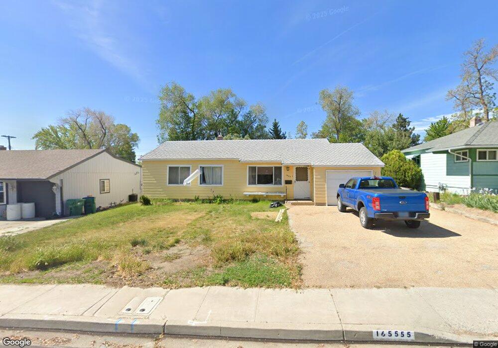
1655 Keystone Ave Reno, NV 89503
Kings Row NeighborhoodEstimated Value: $482,000 - $542,000
4
Beds
2
Baths
1,740
Sq Ft
$287/Sq Ft
Est. Value
About This Home
This home is located at 1655 Keystone Ave, Reno, NV 89503 and is currently estimated at $500,238, approximately $287 per square foot. 1655 Keystone Ave is a home located in Washoe County with nearby schools including Peavine Elementary School, Archie Clayton Pre-AP Academy, and Reno High School.
Ownership History
Date
Name
Owned For
Owner Type
Purchase Details
Closed on
Jun 16, 2021
Sold by
Aiazzi Lamar and Estate Of Roberta Jean Aiazzi
Bought by
Aiazzi Lamar
Current Estimated Value
Purchase Details
Closed on
Oct 24, 2016
Sold by
Aiazzi Lamar and Aiazzi Raymond G
Bought by
Aiazzi Lamar
Purchase Details
Closed on
Oct 11, 2016
Sold by
Aiazzi Lamar
Bought by
Aiazzi Lamar
Create a Home Valuation Report for This Property
The Home Valuation Report is an in-depth analysis detailing your home's value as well as a comparison with similar homes in the area
Home Values in the Area
Average Home Value in this Area
Purchase History
| Date | Buyer | Sale Price | Title Company |
|---|---|---|---|
| Aiazzi Lamar | -- | None Available | |
| Aiazzi Lamar | -- | None Available | |
| Aiazzi Lamar | -- | None Available |
Source: Public Records
Tax History Compared to Growth
Tax History
| Year | Tax Paid | Tax Assessment Tax Assessment Total Assessment is a certain percentage of the fair market value that is determined by local assessors to be the total taxable value of land and additions on the property. | Land | Improvement |
|---|---|---|---|---|
| 2026 | $715 | $57,235 | $34,242 | $22,993 |
| 2025 | $932 | $58,641 | $35,816 | $22,826 |
| 2024 | $932 | $56,221 | $33,737 | $22,485 |
| 2023 | $674 | $56,097 | $35,280 | $20,817 |
| 2022 | $879 | $45,292 | $28,350 | $16,942 |
| 2021 | $855 | $35,659 | $19,121 | $16,538 |
| 2020 | $829 | $34,199 | $17,987 | $16,212 |
| 2019 | $806 | $33,614 | $18,270 | $15,344 |
| 2018 | $782 | $28,417 | $13,732 | $14,685 |
| 2017 | $760 | $26,687 | $12,269 | $14,418 |
| 2016 | $745 | $25,247 | $10,773 | $14,474 |
| 2015 | $174 | $23,452 | $9,144 | $14,308 |
| 2014 | $633 | $21,594 | $8,146 | $13,448 |
| 2013 | -- | $18,861 | $5,819 | $13,042 |
Source: Public Records
Map
Nearby Homes
- 1375 Wesley Dr
- 1415 Kings Row
- 1620 Harold Dr
- 1510 Majestic Dr Unit one
- 1670 Majestic Dr
- 850 W 11th St
- 2120 Keystone Ave
- 1840 Windsor Way
- 2000 Royal Dr
- 880 Ruby Ave
- 720 Stoker Ave
- 948 Washington St
- 1535 Van Ness Ave
- 903 W 7th St
- 1450 Wyoming Ave
- 407 Imperial Blvd
- 960 Ralston St
- 1600 Carlin St
- 1100 Mission Cir
- 2080 Marlette Ave
- 1635 Keystone Ave
- 1675 Keystone Ave
- 1330 Wesley Dr
- 1340 Wesley Dr
- 80 Anson Dr
- 1320 Wesley Dr
- 60 Anson Dr
- 1360 Wesley Dr
- 1312 Wesley Dr
- 1605 Keystone Ave
- 1620 Keystone Ave
- 40 Anson Dr
- 1630 Keystone Ave
- 1612 Keystone Ave
- 1640 Keystone Ave
- 1302 Wesley Dr
- 1606 Keystone Ave
- 20 Anson Dr
- 1585 Keystone Ave
- 1690 Keystone Ave