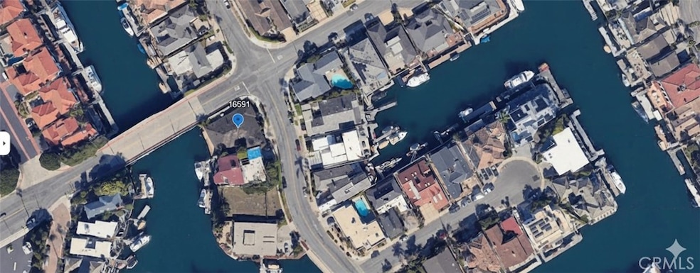
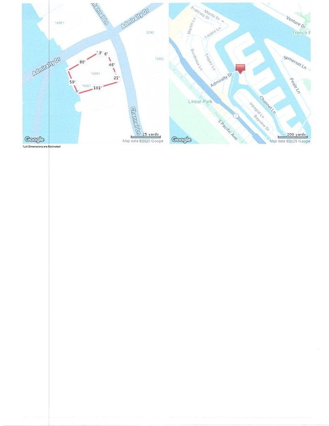
16591 Channel Ln Huntington Beach, CA 92649
Sunset Beach NeighborhoodEstimated payment $14,586/month
Highlights
- Private Dock Site
- Fishing
- Private Yard
- Agnes L. Smith Elementary Rated A-
- Home fronts a canal
- No HOA
About This Home
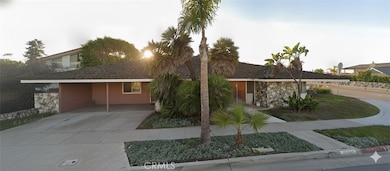
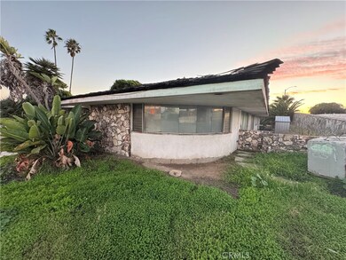
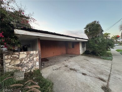
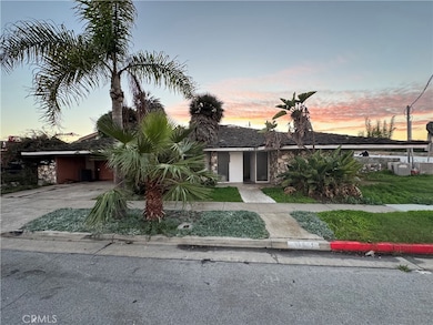
Major fixer in the heart of Huntington Harbour, offering rare canal-front living with a private boat dock. This 5-bedroom, 4-bath with 3,599sf living home sits on a prime 7,100 sq ft lot and presents an exceptional opportunity for a buyer to remodel or reimagine within the existing footprint. Properties in this location seldom come available, and the setting delivers quiet waterfront views and direct access to the Harbour. Ideal for those seeking a project with significant long-term upside in one of Huntington Beach’s most desirable coastal neighborhoods.
Home Details
Home Type
- Single Family
Est. Annual Taxes
- $3,920
Year Built
- Built in 1964
Lot Details
- 7,100 Sq Ft Lot
- Home fronts a canal
- Private Yard
Parking
- 2 Car Attached Garage
- 2 Open Parking Spaces
- Driveway
- On-Street Parking
Home Design
- Entry on the 1st floor
- Stucco
Interior Spaces
- 3,599 Sq Ft Home
- 1-Story Property
- Family Room with Fireplace
- Living Room with Fireplace
- Dining Room with Fireplace
- Canal Views
- Laundry Room
Bedrooms and Bathrooms
- 5 Main Level Bedrooms
- 4 Full Bathrooms
Outdoor Features
- Private Dock Site
- Concrete Porch or Patio
- Exterior Lighting
Listing and Financial Details
- Tax Lot 4
- Tax Tract Number 4499
- Assessor Parcel Number 17843201
- $392 per year additional tax assessments
- Seller Considering Concessions
Community Details
Overview
- No Home Owners Association
- Gilbert Island Subdivision
Recreation
- Fishing
- Water Sports
- Bike Trail
Map
Home Values in the Area
Average Home Value in this Area
Tax History
| Year | Tax Paid | Tax Assessment Tax Assessment Total Assessment is a certain percentage of the fair market value that is determined by local assessors to be the total taxable value of land and additions on the property. | Land | Improvement |
|---|---|---|---|---|
| 2025 | $3,920 | $326,404 | $112,700 | $213,704 |
| 2024 | $3,920 | $320,004 | $110,490 | $209,514 |
| 2023 | $3,830 | $313,730 | $108,324 | $205,406 |
| 2022 | $3,653 | $307,579 | $106,200 | $201,379 |
| 2021 | $3,585 | $301,549 | $104,118 | $197,431 |
| 2020 | $3,560 | $298,457 | $103,050 | $195,407 |
| 2019 | $3,519 | $292,605 | $101,029 | $191,576 |
| 2018 | $3,464 | $286,868 | $99,048 | $187,820 |
| 2017 | $3,416 | $281,244 | $97,106 | $184,138 |
| 2016 | $3,270 | $275,730 | $95,202 | $180,528 |
| 2015 | $3,236 | $271,589 | $93,772 | $177,817 |
| 2014 | $3,167 | $266,269 | $91,935 | $174,334 |
Property History
| Date | Event | Price | List to Sale | Price per Sq Ft |
|---|---|---|---|---|
| 11/22/2025 11/22/25 | For Sale | $2,700,000 | -- | $750 / Sq Ft |
Purchase History
| Date | Type | Sale Price | Title Company |
|---|---|---|---|
| Grant Deed | -- | -- | |
| Interfamily Deed Transfer | -- | First Amer Ttl Co Glendale |
Mortgage History
| Date | Status | Loan Amount | Loan Type |
|---|---|---|---|
| Previous Owner | $900,000 | New Conventional |
Source: California Regional Multiple Listing Service (CRMLS)
MLS Number: SB25265088
APN: 178-432-01
Disclaimer: Certain information contained herein is derived from information provided by parties other than Homes.com. All information provided is deemed reliable, but is not guaranteed to be accurate and should be independently verified.
![]() The multiple listing data appearing on this website, or contained in reports produced therefrom, is owned and copyrighted by California Regional Multiple Listing Service, Inc. ("CRMLS") and is protected by all applicable copyright laws. Information provided is for viewer's personal, non-commercial use and may not be used for any purpose other than to identify prospective properties the viewer may be interested in purchasing. All listing data, including but not limited to square footage and lot size is believed to be accurate, but the listing Agent, listing Broker and CRMLS and its affiliates do not warrant or guarantee such accuracy. The viewer should independently verify the listed data prior to making any decisions based on such information by personal inspection and/or contacting a real estate professional.
The multiple listing data appearing on this website, or contained in reports produced therefrom, is owned and copyrighted by California Regional Multiple Listing Service, Inc. ("CRMLS") and is protected by all applicable copyright laws. Information provided is for viewer's personal, non-commercial use and may not be used for any purpose other than to identify prospective properties the viewer may be interested in purchasing. All listing data, including but not limited to square footage and lot size is believed to be accurate, but the listing Agent, listing Broker and CRMLS and its affiliates do not warrant or guarantee such accuracy. The viewer should independently verify the listed data prior to making any decisions based on such information by personal inspection and/or contacting a real estate professional.
Based on information from California Regional Multiple Listing Service, Inc. and /or other sources. All data, including all measurements and calculations of area, is obtained from various sources and has not been, and will not be, verified by broker or MLS. All information should be independently reviewed and verified for accuracy. Properties may or may not be listed by the office/agent presenting the information
- 16745 Bayview Dr Unit B
- 16746 Pacific Coast Hwy
- 16775 Bayview Dr
- 16502 Mariana Cir
- 16601 S Pacific Ave
- 16778 Bayview Dr Unit B
- 3201 Francois Dr Unit 67
- 16351 Spartan Cir
- 3562 Venture Dr
- 16312 Spartan Cir
- 16291 Countess Dr Unit 211
- 16291 Countess Dr Unit 105
- 3299 Tempe Dr
- 1 Anderson St
- 16935 S Pacific Ave
- 16255 Pacific Cir Unit 106
- 16611 Carousel Ln
- 16661 Carousel Ln
- 3476 Windspun Dr
- 16561 Wanderer Ln
- 16735 Bayview Dr
- 16788 Bayview Dr Unit B
- 16775 15th St Unit B
- 3211 Anne Cir Unit 102
- 16765 S Pacific Ave Unit 'B'
- 16602 Wellington Cir
- 16511 23rd St
- 16511 23rd St
- 16459 24th St
- 16887 S Pacific Ave
- 3310 Tempe Dr
- 17016 7th St
- 16973 Bluewater Ln Unit 71
- 17165 Pacific Coast Hwy Unit B2
- 17140 Bluewater Ln Unit 154
- 4176 Delphi Cir
- 16842 Harkness Cir
- 16700 Saybrook Ln
- 16682 Algonquin St
- 16621 Dolores Ln Unit B
