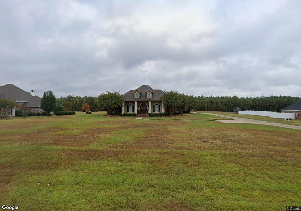
166 Belle Pointe Dr Ruston, LA 71270
Estimated Value: $363,000 - $495,298
3
Beds
3
Baths
2,471
Sq Ft
$172/Sq Ft
Est. Value
About This Home
This home is located at 166 Belle Pointe Dr, Ruston, LA 71270 and is currently estimated at $426,075, approximately $172 per square foot. 166 Belle Pointe Dr is a home located in Lincoln Parish with nearby schools including Choudrant Elementary School, Choudrant High School, and Ruston Junior High School.
Ownership History
Date
Name
Owned For
Owner Type
Purchase Details
Closed on
Jan 15, 2009
Sold by
Stc Llc
Bought by
Harris John Alfred and Harris Robin Alexander
Current Estimated Value
Home Financials for this Owner
Home Financials are based on the most recent Mortgage that was taken out on this home.
Original Mortgage
$38,990
Outstanding Balance
$24,094
Interest Rate
5.09%
Mortgage Type
Unknown
Estimated Equity
$401,981
Create a Home Valuation Report for This Property
The Home Valuation Report is an in-depth analysis detailing your home's value as well as a comparison with similar homes in the area
Purchase History
| Date | Buyer | Sale Price | Title Company |
|---|---|---|---|
| Harris John Alfred | $38,000 | None Available |
Source: Public Records
Mortgage History
| Date | Status | Borrower | Loan Amount |
|---|---|---|---|
| Open | Harris John Alfred | $38,990 |
Source: Public Records
Tax History
| Year | Tax Paid | Tax Assessment Tax Assessment Total Assessment is a certain percentage of the fair market value that is determined by local assessors to be the total taxable value of land and additions on the property. | Land | Improvement |
|---|---|---|---|---|
| 2025 | $3,243 | $41,050 | $6,208 | $34,842 |
| 2024 | $3,243 | $41,050 | $6,208 | $34,842 |
| 2023 | $2,964 | $35,980 | $4,240 | $31,740 |
| 2022 | $2,944 | $35,980 | $4,240 | $31,740 |
| 2021 | $2,897 | $35,981 | $4,240 | $31,741 |
| 2020 | $2,903 | $35,981 | $4,240 | $31,741 |
| 2019 | $3,054 | $37,354 | $4,240 | $33,114 |
| 2018 | $3,056 | $37,354 | $4,240 | $33,114 |
| 2017 | $3,064 | $37,354 | $4,240 | $33,114 |
| 2016 | $3,106 | $0 | $0 | $0 |
| 2015 | $2,851 | $31,438 | $4,180 | $27,258 |
| 2013 | $2,782 | $30,199 | $4,180 | $26,019 |
Source: Public Records
Map
Nearby Homes
- 173 Oak Alley Dr
- 144 Creeks Crossing
- 145 Woodshire Ln
- 155 Creekside Dr
- 209 Burgessville Rd
- 128 Marlou Cir
- 185 Mount Harmony Church Rd
- 197 Baxter Rd
- Lot 1B Unit 1 Harmony Church Rd
- 641 Goodgoin Rd
- 294 Moody Rd
- 136 Shade Tree Trace
- 0 Spillers Rd
- 392 Tremont Dr
- 2420 Highway 33
- 634 Cheatwood Rd
- 1950 Louisiana 821
- 201 Vintage Ln
- 0 Louisiana 33
- 1709 Rampart Dr
- 152 Belle Pointe Dr
- 180 Belle Pointe Dr
- 173 Belle Pointe Dr
- 192 Belle Pointe Dr
- 136 Belle Pointe Dr
- 155 Belle Pointe Dr
- 137 Belle Pointe Dr
- 125 Ramsey Cir
- 197 Belle Pointe Dr
- 206 Belle Pointe Dr
- 135 Ramsey Cir
- 146 Ramsey Cir
- 2867 Highway 821
- 2867 Highway 821
- 2867 Highway 821
- 2857 Highway 821
- 116 Belle Pointe Dr
- 217 Belle Pointe Dr
- 147 Ramsey Cir
- 9 Belle Pointe Dr
Your Personal Tour Guide
Ask me questions while you tour the home.