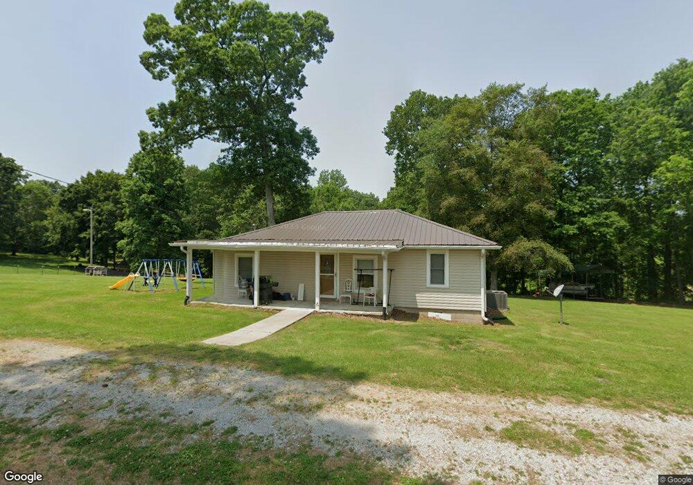
166 Pate Ln Dickson, TN 37055
Estimated Value: $235,133 - $265,000
--
Bed
1
Bath
936
Sq Ft
$266/Sq Ft
Est. Value
About This Home
This home is located at 166 Pate Ln, Dickson, TN 37055 and is currently estimated at $248,783, approximately $265 per square foot. 166 Pate Ln is a home located in Dickson County with nearby schools including Stuart Burns Elementary School, Burns Middle School, and Dickson County High School.
Ownership History
Date
Name
Owned For
Owner Type
Purchase Details
Closed on
Sep 18, 2015
Sold by
Macioci Carol
Bought by
Macioci Charles and Macioci Carol
Current Estimated Value
Home Financials for this Owner
Home Financials are based on the most recent Mortgage that was taken out on this home.
Original Mortgage
$35,000
Interest Rate
3.97%
Mortgage Type
New Conventional
Purchase Details
Closed on
Aug 26, 1997
Sold by
Lampley Betty and Lampley Jerry
Bought by
Baker Carol
Purchase Details
Closed on
Jun 2, 1997
Sold by
Mitchell James G
Bought by
Lampley Betty and Lampley Jerry
Purchase Details
Closed on
Oct 5, 1951
Bought by
Mitchell James G and Rosa Mai
Create a Home Valuation Report for This Property
The Home Valuation Report is an in-depth analysis detailing your home's value as well as a comparison with similar homes in the area
Home Values in the Area
Average Home Value in this Area
Purchase History
| Date | Buyer | Sale Price | Title Company |
|---|---|---|---|
| Macioci Charles | -- | -- | |
| Baker Carol | $1,000 | -- | |
| Lampley Betty | $2,000 | -- | |
| Mitchell James G | -- | -- |
Source: Public Records
Mortgage History
| Date | Status | Borrower | Loan Amount |
|---|---|---|---|
| Closed | Macioci Charles | $35,000 |
Source: Public Records
Tax History Compared to Growth
Tax History
| Year | Tax Paid | Tax Assessment Tax Assessment Total Assessment is a certain percentage of the fair market value that is determined by local assessors to be the total taxable value of land and additions on the property. | Land | Improvement |
|---|---|---|---|---|
| 2024 | $723 | $42,775 | $21,550 | $21,225 |
| 2023 | $569 | $24,225 | $8,025 | $16,200 |
| 2022 | $569 | $24,225 | $8,025 | $16,200 |
| 2021 | $569 | $24,225 | $8,025 | $16,200 |
| 2020 | $569 | $24,225 | $8,025 | $16,200 |
| 2019 | $569 | $24,225 | $8,025 | $16,200 |
| 2018 | $450 | $16,650 | $7,200 | $9,450 |
| 2017 | $450 | $16,650 | $7,200 | $9,450 |
| 2016 | $450 | $16,650 | $7,200 | $9,450 |
| 2015 | $438 | $15,100 | $7,200 | $7,900 |
| 2014 | $438 | $15,100 | $7,200 | $7,900 |
Source: Public Records
Map
Nearby Homes
- 1021 Woodmont Dr
- 0 Ridgecrest Dr
- 1122 Ridgecrest Dr
- 145 Bishop Ln
- 4 Myatt Loop
- 1 Myatt Loop
- 1032 Gordon Cir
- 101 Brookstone Dr
- 201 Brady Dr
- 312 Parkway Dr
- 106 Meadowood Loop
- 0 Jones Creek Rd Unit RTC2975835
- 0 Jones Creek Rd Unit RTC2975735
- 0 Treemont Dr Unit RTC2792107
- 1165 Rock Church Rd
- 236 Old Columbia Rd
- 112 Hillwood Dr
- 1017 Preston Dr
- 123 Eastdale Ln
- 986 Hall Cemetery Rd
- 162 Pate Ln
- 160 Pate Ln
- 150 Pate Ln
- 1017 Belmont Dr
- 0 Belmont Dr
- 1015 Belmont Dr
- 1013 Belmont Dr
- 1016 Belmont Dr
- 1009 Belmont Dr
- 1022 Belmont Dr
- 1014 Belmont Dr
- 190 Pate Ln
- 1021 Belmont Dr
- 1019 Highland Dr
- 1005 Belmont Dr
- 1023 Highland Dr
- 1008 Belmont Dr
- 1017 Highland Dr
- 1023 Belmont Dr
- 1015 Highland Dr