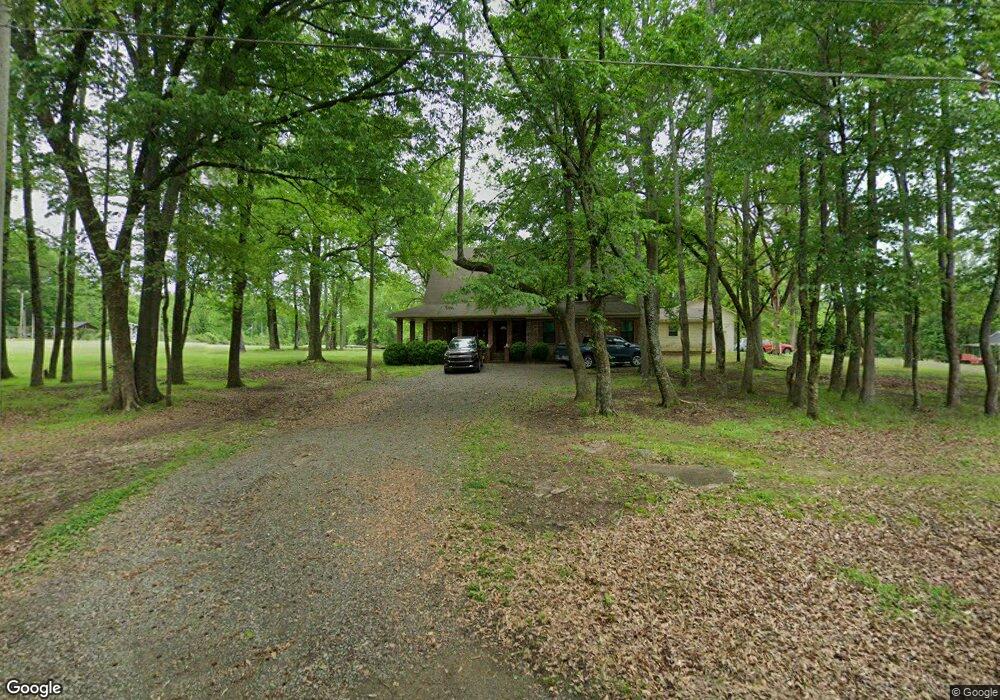
1661 Ray Sowell Rd Austin, AR 72007
Estimated Value: $330,000 - $566,000
Studio
3
Baths
3,184
Sq Ft
$139/Sq Ft
Est. Value
About This Home
This home is located at 1661 Ray Sowell Rd, Austin, AR 72007 and is currently estimated at $443,812, approximately $139 per square foot. 1661 Ray Sowell Rd is a home located in Lonoke County with nearby schools including Eastside Elementary School, Cabot Middle School North, and Cabot Junior High North.
Ownership History
Date
Name
Owned For
Owner Type
Purchase Details
Closed on
Sep 5, 2024
Sold by
Ballard Michael L and Ballard Lana
Bought by
Ballard Michael L and Webb Brandon
Current Estimated Value
Purchase Details
Closed on
Jul 14, 2021
Sold by
Clay Renee and Estate Of Joyce Louise
Bought by
Ballard Michael L and Ballard Lana
Purchase Details
Closed on
Jun 3, 1992
Bought by
Ballard and Wife Lana
Create a Home Valuation Report for This Property
The Home Valuation Report is an in-depth analysis detailing your home's value as well as a comparison with similar homes in the area
Purchase History
| Date | Buyer | Sale Price | Title Company |
|---|---|---|---|
| Ballard Michael L | -- | Liberty Title | |
| Ballard Michael L | $60,000 | None Available | |
| Ballard | -- | -- |
Source: Public Records
Tax History
| Year | Tax Paid | Tax Assessment Tax Assessment Total Assessment is a certain percentage of the fair market value that is determined by local assessors to be the total taxable value of land and additions on the property. | Land | Improvement |
|---|---|---|---|---|
| 2025 | $2,059 | $60,920 | $2,000 | $58,920 |
| 2024 | $2,059 | $60,920 | $2,000 | $58,920 |
| 2023 | $2,059 | $60,920 | $2,000 | $58,920 |
| 2022 | $2,228 | $60,920 | $2,000 | $58,920 |
| 2021 | $2,109 | $60,920 | $2,000 | $58,920 |
| 2020 | $1,991 | $51,540 | $1,500 | $50,040 |
| 2019 | $1,991 | $51,540 | $1,500 | $50,040 |
| 2018 | $2,016 | $51,540 | $1,500 | $50,040 |
| 2017 | $2,171 | $51,540 | $1,500 | $50,040 |
| 2016 | $2,001 | $51,540 | $1,500 | $50,040 |
| 2015 | $1,859 | $48,130 | $1,500 | $46,630 |
| 2014 | $1,859 | $48,130 | $1,500 | $46,630 |
Source: Public Records
Map
Nearby Homes
- 1771 Ray Sowell Rd
- 1821 Ray Sowell Rd
- 1761 Ray Sowell Rd
- 1445 Ray Sowell Rd
- 1435 Ray Sowell Rd
- 1835 Ray Sowell Rd
- 1558 Ray Sowell Rd
- 1550 Ray Sowell Rd
- 1643 Ray Sowell Rd
- 1441 Ray Sowell Rd
- 135 Sherry Dr
- 1994 Ray Sowell Rd
- 15 Samantha Dr
- 2006 Ray Sowell Rd
- 26 Samantha Dr
- 124 Sherry Dr
- 255 Samantha Ln
- 255 Samantha Dr
- 2002 Ray Sowell Rd
- 174 Wild Rose Cove
Your Personal Tour Guide
Ask me questions while you tour the home.