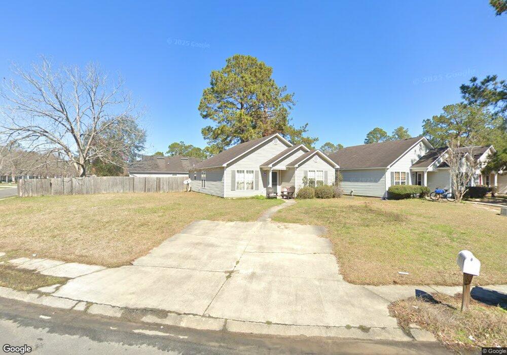
1664 Fresno St Valdosta, GA 31602
Estimated Value: $138,772 - $161,000
3
Beds
2
Baths
1,309
Sq Ft
$118/Sq Ft
Est. Value
About This Home
This home is located at 1664 Fresno St, Valdosta, GA 31602 and is currently estimated at $154,443, approximately $117 per square foot. 1664 Fresno St is a home located in Lowndes County with nearby schools including W.G. Nunn Elementary School, Newbern Middle School, and Valdosta High School.
Ownership History
Date
Name
Owned For
Owner Type
Purchase Details
Closed on
Oct 29, 2021
Sold by
Martin Kevin D
Bought by
Starling Indi Bleu
Current Estimated Value
Purchase Details
Closed on
May 15, 2009
Sold by
Daniels John P
Bought by
Martin Kevin D and Rikard Timmy B
Home Financials for this Owner
Home Financials are based on the most recent Mortgage that was taken out on this home.
Original Mortgage
$92,198
Interest Rate
4.79%
Mortgage Type
FHA
Purchase Details
Closed on
Aug 19, 2003
Sold by
Daniels John P
Bought by
Daniels Charlotte
Purchase Details
Closed on
Feb 27, 2003
Sold by
Chrismill Homes Inc
Bought by
Daniels John P
Purchase Details
Closed on
Feb 5, 2003
Sold by
Cowart J C
Bought by
Chrismill Homes Inc
Create a Home Valuation Report for This Property
The Home Valuation Report is an in-depth analysis detailing your home's value as well as a comparison with similar homes in the area
Home Values in the Area
Average Home Value in this Area
Purchase History
| Date | Buyer | Sale Price | Title Company |
|---|---|---|---|
| Starling Indi Bleu | $100,000 | -- | |
| Martin Kevin D | $93,900 | -- | |
| Daniels Charlotte | -- | -- | |
| Daniels John P | $12,000 | -- | |
| Chrismill Homes Inc | $701,500 | -- |
Source: Public Records
Mortgage History
| Date | Status | Borrower | Loan Amount |
|---|---|---|---|
| Previous Owner | Martin Kevin D | $92,198 |
Source: Public Records
Tax History Compared to Growth
Tax History
| Year | Tax Paid | Tax Assessment Tax Assessment Total Assessment is a certain percentage of the fair market value that is determined by local assessors to be the total taxable value of land and additions on the property. | Land | Improvement |
|---|---|---|---|---|
| 2024 | $1,254 | $37,842 | $5,000 | $32,842 |
| 2023 | $889 | $37,842 | $5,000 | $32,842 |
| 2022 | $1,192 | $35,270 | $5,000 | $30,270 |
| 2021 | $862 | $24,792 | $5,000 | $19,792 |
| 2020 | $881 | $24,792 | $5,000 | $19,792 |
| 2019 | $880 | $24,792 | $5,000 | $19,792 |
| 2018 | $724 | $20,135 | $5,000 | $15,135 |
| 2017 | $1,024 | $28,285 | $5,000 | $23,285 |
| 2016 | $1,023 | $28,285 | $5,000 | $23,285 |
| 2015 | $939 | $28,285 | $5,000 | $23,285 |
| 2014 | $954 | $29,249 | $4,800 | $24,449 |
Source: Public Records
Map
Nearby Homes
- 1647 Fresno St
- 1703 Largo Cir
- 2745 Pineview Dr
- 1 Pomona Cir
- 2570 Marathon Dr
- 2570 Forrestwood Dr
- 2320 Barack Obama Blvd
- 2400 Lowndes Dr
- 2323 Frederick Place
- 1507 Leone Ave
- 1852 Chestnut Dr
- 0 Northside Dr Unit 145194
- 908 Habersham Rd
- 1642 Lexington Cir
- 904 Habersham Rd
- 2318 Frederick Place
- 1703 Leone Ave
- 2802 Tyndall Dr
- 2032 Bancroft Rd
- 9 Oconee Place
- 1670 Fresno St
- 1656 Fresno St
- 1706 Fresno St
- 1654 Fresno St
- 1708 Fresno St
- 1659 Fresno St
- 1652 Fresno St
- 1657 Fresno St
- 1661 Fresno St
- 1655 Fresno St
- 2534 Forrestwood Dr
- 1703 Fresno St
- 2532 Forrestwood Dr
- 1710 Fresno St
- 1663 Fresno St
- 1653 Fresno St
- 1701 Fresno St
- 1705 Fresno St
- 1650 Fresno St
- 1707 Fresno St