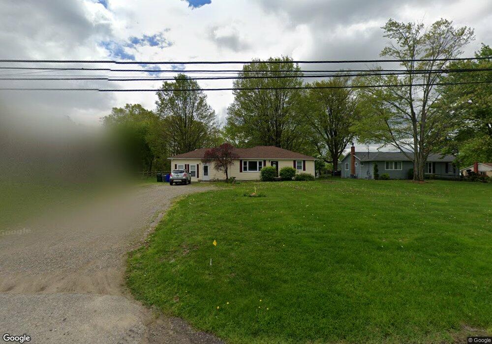
1664 State Route 303 Streetsboro, OH 44241
Estimated Value: $230,000 - $249,703
3
Beds
2
Baths
1,584
Sq Ft
$151/Sq Ft
Est. Value
About This Home
This home is located at 1664 State Route 303, Streetsboro, OH 44241 and is currently estimated at $239,176, approximately $150 per square foot. 1664 State Route 303 is a home located in Portage County with nearby schools including Streetsboro High School and Crossroads Christian Academy.
Ownership History
Date
Name
Owned For
Owner Type
Purchase Details
Closed on
Jan 31, 2012
Sold by
Baird Steven Richard
Bought by
Baird Darlene Marie
Current Estimated Value
Purchase Details
Closed on
Jun 7, 1999
Sold by
Baird Raymond L and Baird Kathleen M
Bought by
Baird Steven Richard and Baird Darlene Marie
Home Financials for this Owner
Home Financials are based on the most recent Mortgage that was taken out on this home.
Original Mortgage
$80,000
Outstanding Balance
$21,516
Interest Rate
7.29%
Estimated Equity
$217,660
Purchase Details
Closed on
Jan 1, 1990
Bought by
Baird Raymond L
Create a Home Valuation Report for This Property
The Home Valuation Report is an in-depth analysis detailing your home's value as well as a comparison with similar homes in the area
Home Values in the Area
Average Home Value in this Area
Purchase History
| Date | Buyer | Sale Price | Title Company |
|---|---|---|---|
| Baird Darlene Marie | -- | Attorney | |
| Baird Steven Richard | $100,000 | Approved Statewide Title Age | |
| Baird Raymond L | -- | -- |
Source: Public Records
Mortgage History
| Date | Status | Borrower | Loan Amount |
|---|---|---|---|
| Open | Baird Steven Richard | $80,000 |
Source: Public Records
Tax History Compared to Growth
Tax History
| Year | Tax Paid | Tax Assessment Tax Assessment Total Assessment is a certain percentage of the fair market value that is determined by local assessors to be the total taxable value of land and additions on the property. | Land | Improvement |
|---|---|---|---|---|
| 2024 | $2,869 | $69,410 | $15,050 | $54,360 |
| 2023 | $2,759 | $54,640 | $14,000 | $40,640 |
| 2021 | $2,773 | $54,640 | $14,000 | $40,640 |
| 2020 | $2,617 | $47,320 | $14,000 | $33,320 |
| 2019 | $2,641 | $47,320 | $14,000 | $33,320 |
| 2018 | $2,169 | $44,870 | $14,420 | $30,450 |
| 2017 | $2,226 | $44,870 | $14,420 | $30,450 |
| 2016 | $2,284 | $44,870 | $14,420 | $30,450 |
| 2015 | $2,288 | $44,870 | $14,420 | $30,450 |
| 2014 | $2,308 | $44,870 | $14,420 | $30,450 |
| 2013 | $2,242 | $44,870 | $14,420 | $30,450 |
Source: Public Records
Map
Nearby Homes
- 9244 Lakeside Dr
- 9018 Patriot Dr
- 9012 Patriot Dr
- 1446 Trader Dr Unit H5
- 1440 Trader Dr
- 1648 Maple View Ct
- 8807 Kelly Ln
- 1490 Evergreen Dr
- 9315 June Dr
- V/L State Route 14
- 1489 Crescent Dr
- 1516 Gillie Dr
- 1725 Pike Pkwy
- 1405 Gillie Dr
- 1654 Leslie Dr
- 1280 Shawnee Trail
- 1678 Duncan Way
- 1675 Duncan Way
- 1448 Jude Ave
- 1159 Shawnee Trail
- 1674 State Route 303
- 1654 State Route 303
- 1654 Ohio 303
- 1682 State Route 303
- 1644 State Route 303
- 1663 State Route 303
- 1634 State Route 303
- 1673 State Route 303
- 1653 State Route 303
- 1641 State Route 303
- 1624 State Route 303
- 1691 State Route 303
- 1691 Ohio 303
- 9147 Root Dr
- 1706 Ohio 303
- 9146 Briar Dr
- 1706 State Route 303
- 1701 State Route 303
- 1714 Ohio 303
- 1625 State Route 303