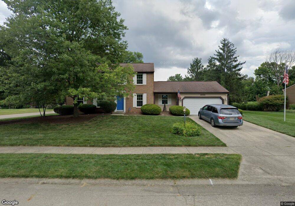
1666 Bledsoe Dr Bellbrook, OH 45305
Estimated Value: $393,213 - $443,000
4
Beds
3
Baths
2,196
Sq Ft
$188/Sq Ft
Est. Value
About This Home
This home is located at 1666 Bledsoe Dr, Bellbrook, OH 45305 and is currently estimated at $412,303, approximately $187 per square foot. 1666 Bledsoe Dr is a home located in Greene County with nearby schools including Stephen Bell Elementary School, Bell Creek Intermediate School, and Bellbrook Middle School.
Ownership History
Date
Name
Owned For
Owner Type
Purchase Details
Closed on
Aug 29, 1990
Bought by
Westfall Philip J and Westfall Westfall
Current Estimated Value
Create a Home Valuation Report for This Property
The Home Valuation Report is an in-depth analysis detailing your home's value as well as a comparison with similar homes in the area
Home Values in the Area
Average Home Value in this Area
Purchase History
| Date | Buyer | Sale Price | Title Company |
|---|---|---|---|
| Westfall Philip J | $145,000 | -- |
Source: Public Records
Tax History
| Year | Tax Paid | Tax Assessment Tax Assessment Total Assessment is a certain percentage of the fair market value that is determined by local assessors to be the total taxable value of land and additions on the property. | Land | Improvement |
|---|---|---|---|---|
| 2024 | $6,510 | $111,500 | $19,780 | $91,720 |
| 2023 | $6,265 | $111,500 | $19,780 | $91,720 |
| 2022 | $6,108 | $88,700 | $15,820 | $72,880 |
| 2021 | $6,171 | $88,700 | $15,820 | $72,880 |
| 2020 | $5,767 | $88,700 | $15,820 | $72,880 |
| 2019 | $5,314 | $74,270 | $13,400 | $60,870 |
| 2018 | $5,320 | $74,270 | $13,400 | $60,870 |
| 2017 | $4,904 | $74,270 | $13,400 | $60,870 |
| 2016 | $4,904 | $67,880 | $13,400 | $54,480 |
| 2015 | $4,919 | $67,880 | $13,400 | $54,480 |
| 2014 | $4,556 | $67,880 | $13,400 | $54,480 |
Source: Public Records
Map
Nearby Homes
- 4206 N Golden Clove Bend Unit 56-303
- 4208 N Golden Clove Bend Unit 56-103
- 4214 N Golden Clove Bend Unit 56-102
- 4216 N Golden Clove Bend Unit 56-302
- 4222 N Golden Clove Bend Unit 56-201
- 4218 N Golden Clove Bend Unit 56-300
- 4228 Apple Branch Dr Unit 55-204
- 4232 Apple Branch Dr Unit 55-305
- 4236 Apple Branch Dr Unit 55-103
- 4242 Apple Branch Dr Unit 55-102
- 4246 Apple Branch Dr Unit 55-300
- 4252 Apple Branch Dr Unit 55-201
- 4272 Apple Branch Dr Unit 54-102
- 1641 Honey Tree Place Unit 29-303
- 4206 Sugar Point Way
- 4232 Apple Branch Dr
- 4264 Apple Branch Dr
- 4345 Sweet Maple Ln Unit 2-B
- 4220 Golden Clove Bend
- 4218 Golden Clove Bend
- 1674 Bledsoe Dr
- 1651 Garry Dr
- 1648 Bledsoe Dr
- 1682 Bledsoe Dr
- 1644 Garry Dr
- 1665 Bledsoe Dr
- 1667 Garry Dr
- 1657 Bledsoe Dr
- 1673 Bledsoe Dr
- 1681 Bledsoe Dr
- 1652 Garry Dr
- 1640 Bledsoe Dr
- 1690 Bledsoe Dr
- 1649 Bledsoe Dr
- 1683 Garry Dr
- 1641 Bledsoe Dr
- 1689 Bledsoe Dr
- 1698 Bledsoe Dr
- 1691 Garry Dr
- 1668 Garry Dr
Your Personal Tour Guide
Ask me questions while you tour the home.