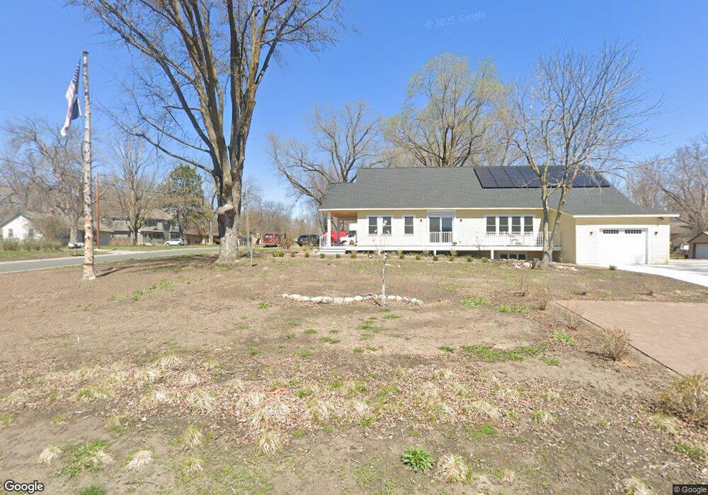
1666 Howard Ave Maple Plain, MN 55359
Estimated Value: $358,404 - $542,000
1
Bed
4
Baths
1,704
Sq Ft
$249/Sq Ft
Est. Value
About This Home
This home is located at 1666 Howard Ave, Maple Plain, MN 55359 and is currently estimated at $424,601, approximately $249 per square foot. 1666 Howard Ave is a home located in Hennepin County with nearby schools including Schumann Elementary School, Orono Intermediate Elementary School, and Orono Middle School.
Ownership History
Date
Name
Owned For
Owner Type
Purchase Details
Closed on
Aug 30, 2022
Sold by
Ferril Eleanor
Bought by
Eleanor L Ferril Revocable Trust
Current Estimated Value
Purchase Details
Closed on
Aug 25, 2022
Sold by
Shelp John J
Bought by
Ferril Eleanor
Purchase Details
Closed on
Jul 30, 2002
Sold by
Vallard Konrad W and Vallard Angella K
Bought by
Shelp John J and Shelp Michelle L
Purchase Details
Closed on
Jun 9, 2000
Sold by
Beard James S and Beard Janet W
Bought by
Vallard Angella K and Vallard Konrad W
Create a Home Valuation Report for This Property
The Home Valuation Report is an in-depth analysis detailing your home's value as well as a comparison with similar homes in the area
Home Values in the Area
Average Home Value in this Area
Purchase History
| Date | Buyer | Sale Price | Title Company |
|---|---|---|---|
| Eleanor L Ferril Revocable Trust | $304,425 | -- | |
| Ferril Eleanor | $304,426 | -- | |
| Shelp John J | $184,900 | -- | |
| Vallard Angella K | $151,000 | -- |
Source: Public Records
Tax History
| Year | Tax Paid | Tax Assessment Tax Assessment Total Assessment is a certain percentage of the fair market value that is determined by local assessors to be the total taxable value of land and additions on the property. | Land | Improvement |
|---|---|---|---|---|
| 2024 | $7,696 | $449,600 | $95,600 | $354,000 |
| 2023 | $5,496 | $305,100 | $104,000 | $201,100 |
| 2022 | $5,127 | $277,000 | $98,000 | $179,000 |
| 2021 | $4,924 | $241,000 | $87,000 | $154,000 |
| 2020 | $4,946 | $224,000 | $76,000 | $148,000 |
| 2019 | $5,044 | $212,000 | $74,000 | $138,000 |
| 2018 | $2,851 | $203,000 | $66,000 | $137,000 |
| 2017 | $2,745 | $174,000 | $56,000 | $118,000 |
| 2016 | $2,598 | $166,000 | $56,000 | $110,000 |
| 2015 | $2,373 | $152,000 | $49,000 | $103,000 |
| 2014 | -- | $157,000 | $65,000 | $92,000 |
Source: Public Records
Map
Nearby Homes
- 4819 Baker Reserve Ln
- 4842 Baker Reserve Ln
- 4801 Baker Reserve Ln
- 4835 Drake St
- 5183 Independence St
- 2017 Bridgevine Ct
- 5249 Main St E
- 2045 Bridgevine Ct
- 5245 Clayton Dr
- 2084 Bridgevine Ct
- 2101 Bridgevine Ct
- 1635 Delano Ave
- 5340 Main St E
- 2073 Bridgevine Ct
- 2224 Bridgevine Ct
- 4894 Bridgevine Way
- 5112 S Lakeshore Dr
- 2211 Heritage Trail
- 5901 Drake Dr
- TBD 1 Drake Dr
- 1690 Howard Ave
- 1644 Howard Ave
- 4900 Independence St
- 1685 Perkins Ln
- 4919 Independence St
- 1669 Howard Ave
- 1706 Howard Ave
- 1634 Howard Ave
- 1687 Perkins Ln
- 4905 Independence St
- 1685 Howard Ave
- 1645 Howard Ave
- 1718 Howard Ave
- 4887 Independence St
- XXXX Independence St
- 4990 Independence St
- 1701 Howard Ave
- 1668 Perkins Ln
- 4920 Main St E
- 1684 Perkins Ln
Your Personal Tour Guide
Ask me questions while you tour the home.