
Seller's Agent in 2025
Amber Durand
Patterson-Schwartz Real Estate
(410) 877-5093
12 in this area
171 Total Sales
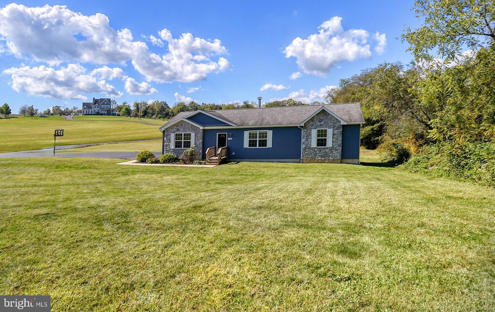
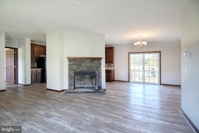
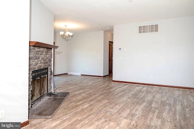
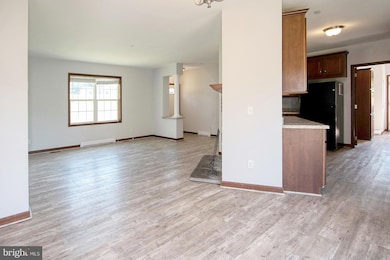
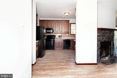
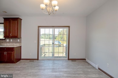
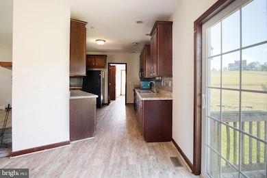
Only 10 years young, this beautiful custom-built rancher offers the perfect blend of modern comfort and peaceful country living — all while being just minutes from local conveniences! Sitting on a private 1.39-acre lot with no restrictions, this home is ready for you to move right in and enjoy. Step inside to discover fresh professional paint and new carpet throughout, a brand-new HVAC (2024), new hot water heater (2025), and new washer & dryer (2024)! The gleaming Luxury Vinyl Plank flooring (2023) adds a touch of elegance, and the freshly blacktopped driveway (2025) welcomes you home in style. The open floor plan features a spacious living room with a cozy electric fireplace, a large and bright kitchen with ample storage, and a convenient laundry area with a pantry located right off the side entrance. The primary bedroom suite is spacious, featuring a large walk-in closet and a generously sized en-suite bath. Two additional bedrooms and a second full bathroom provide ample space for family or guests. Downstairs, you’ll find a full poured-concrete basement — the entire footprint of the home — with a rough-in for a 3-piece bath and an egress window to the backyard, offering endless possibilities for expansion or recreation space. The property also features a low-nitrogen BAT septic system, adding efficiency and peace of mind. Don’t miss this lovingly maintained home in a gorgeous rural setting — offering the best of both worlds: country serenity and modern convenience!
Last Agent to Sell the Property
(410) 885-1606 amber@psre.net Patterson-Schwartz Real Estate License #RB-0020896 Listed on: 10/08/2025
| Date | Type | Sale Price | Title Company |
|---|---|---|---|
| Deed | $400,000 | Liberty Title | |
| Quit Claim Deed | -- | None Listed On Document | |
| Quit Claim Deed | -- | None Listed On Document | |
| Deed | $238,990 | Kirsh Title Services Inc |
| Date | Status | Loan Amount | Loan Type |
|---|---|---|---|
| Open | $392,755 | FHA | |
| Previous Owner | $342,694 | New Conventional | |
| Previous Owner | $90,000 | Purchase Money Mortgage |
| Date | Event | Price | List to Sale | Price per Sq Ft |
|---|---|---|---|---|
| 11/28/2025 11/28/25 | Sold | $400,000 | -3.6% | $126 / Sq Ft |
| 11/12/2025 11/12/25 | Pending | -- | -- | -- |
| 11/07/2025 11/07/25 | Price Changed | $415,000 | -2.4% | $131 / Sq Ft |
| 10/08/2025 10/08/25 | For Sale | $425,000 | -- | $134 / Sq Ft |
| Year | Tax Paid | Tax Assessment Tax Assessment Total Assessment is a certain percentage of the fair market value that is determined by local assessors to be the total taxable value of land and additions on the property. | Land | Improvement |
|---|---|---|---|---|
| 2025 | $3,142 | $281,600 | $81,900 | $199,700 |
| 2024 | $2,653 | $268,900 | $0 | $0 |
| 2023 | $2,189 | $256,200 | $0 | $0 |
| 2022 | $2,803 | $243,500 | $81,900 | $161,600 |
| 2021 | $2,746 | $240,400 | $0 | $0 |
| 2020 | $2,797 | $237,300 | $0 | $0 |
| 2019 | $2,761 | $234,200 | $81,900 | $152,300 |
| 2018 | $2,669 | $226,167 | $0 | $0 |
| 2017 | $2,576 | $218,133 | $0 | $0 |
| 2016 | $2,377 | $210,100 | $0 | $0 |
| 2015 | $2,377 | $79,600 | $0 | $0 |
| 2014 | $900 | $79,600 | $0 | $0 |
Seller's Agent in 2025
Amber Durand
Patterson-Schwartz Real Estate
(410) 877-5093
12 in this area
171 Total Sales
S
Buyer's Agent in 2025
Sherry Willis
Integrity Real Estate
(443) 553-1111
7 in this area
32 Total Sales
Source: Bright MLS
MLS Number: MDCC2019338
APN: 06-053653
Disclaimer: Certain information contained herein is derived from information provided by parties other than Homes.com. All information provided is deemed reliable, but is not guaranteed to be accurate and should be independently verified.
![]() The data relating to real estate for sale on this website appears in part through the BRIGHT Internet Data Exchange program, a voluntary cooperative exchange of property listing data between licensed real estate brokerage firms, and is provided by BRIGHT through a licensing agreement.
The data relating to real estate for sale on this website appears in part through the BRIGHT Internet Data Exchange program, a voluntary cooperative exchange of property listing data between licensed real estate brokerage firms, and is provided by BRIGHT through a licensing agreement.
Listing information is from various brokers who participate in the Bright MLS IDX program and not all listings may be visible on the site.
The property information being provided on or through the website is for the personal, non-commercial use of consumers and such information may not be used for any purpose other than to identify prospective properties consumers may be interested in purchasing.
Some properties which appear for sale on the website may no longer be available because they are for instance, under contract, sold or are no longer being offered for sale.
Property information displayed is deemed reliable but is not guaranteed.
Copyright 2026 Bright MLS, Inc.
Ask me questions while you tour the home.