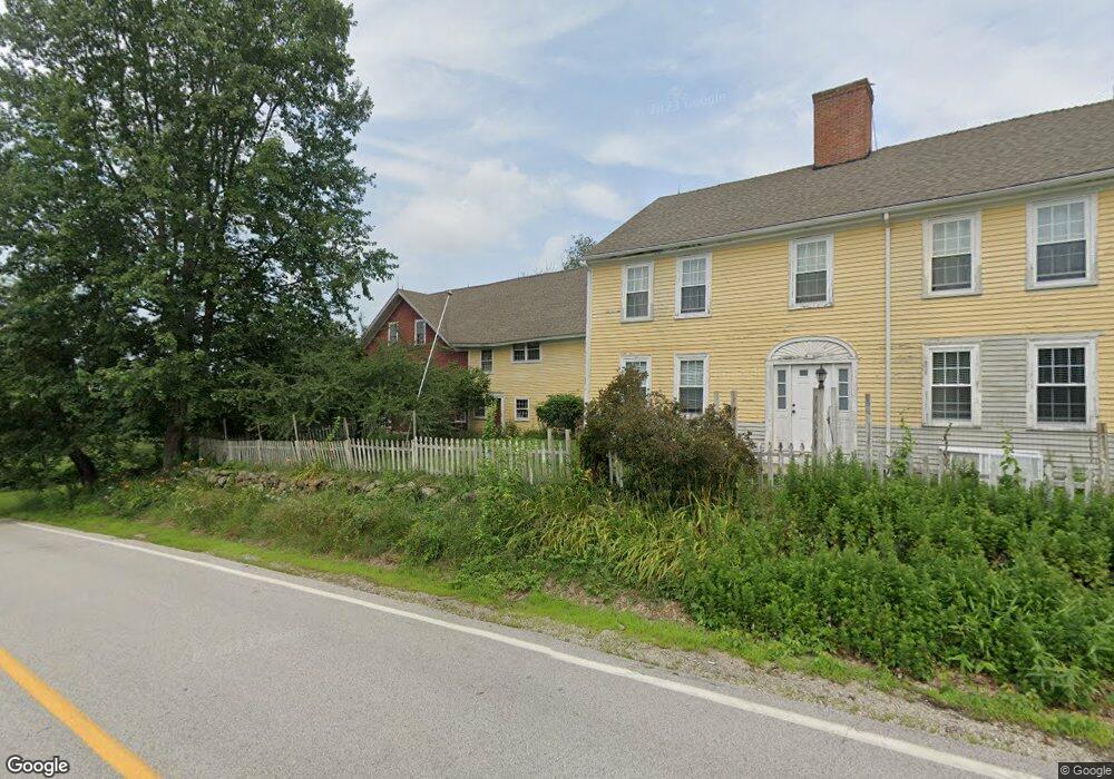
167 Bunker Hill Rd Auburn, NH 03032
Estimated Value: $713,000 - $1,166,000
5
Beds
2
Baths
3,835
Sq Ft
$234/Sq Ft
Est. Value
About This Home
This home is located at 167 Bunker Hill Rd, Auburn, NH 03032 and is currently estimated at $898,388, approximately $234 per square foot. 167 Bunker Hill Rd is a home located in Rockingham County with nearby schools including Auburn Village School, Pinkerton Academy, and Auburn Montessori School.
Ownership History
Date
Name
Owned For
Owner Type
Purchase Details
Closed on
Feb 9, 2017
Sold by
Macaulay David A
Bought by
Macaulay David A and Ruan Wan P
Current Estimated Value
Purchase Details
Closed on
May 26, 2009
Sold by
Deutsche Bk Natl T Co
Bought by
Macaulay David A
Home Financials for this Owner
Home Financials are based on the most recent Mortgage that was taken out on this home.
Original Mortgage
$216,250
Interest Rate
4.93%
Mortgage Type
VA
Purchase Details
Closed on
Dec 9, 2008
Sold by
Graves Matthew G
Bought by
Deutsche Bank Natl T C
Purchase Details
Closed on
May 3, 2004
Sold by
Degroot Robert J
Bought by
Graves Matthew C and Graves Heather L
Home Financials for this Owner
Home Financials are based on the most recent Mortgage that was taken out on this home.
Original Mortgage
$319,500
Interest Rate
5.36%
Mortgage Type
Purchase Money Mortgage
Create a Home Valuation Report for This Property
The Home Valuation Report is an in-depth analysis detailing your home's value as well as a comparison with similar homes in the area
Home Values in the Area
Average Home Value in this Area
Purchase History
| Date | Buyer | Sale Price | Title Company |
|---|---|---|---|
| Macaulay David A | -- | -- | |
| Macaulay David A | $216,200 | -- | |
| Deutsche Bank Natl T C | $280,000 | -- | |
| Graves Matthew C | $355,000 | -- |
Source: Public Records
Mortgage History
| Date | Status | Borrower | Loan Amount |
|---|---|---|---|
| Previous Owner | Graves Matthew C | $216,250 | |
| Previous Owner | Graves Matthew C | $319,500 |
Source: Public Records
Tax History Compared to Growth
Tax History
| Year | Tax Paid | Tax Assessment Tax Assessment Total Assessment is a certain percentage of the fair market value that is determined by local assessors to be the total taxable value of land and additions on the property. | Land | Improvement |
|---|---|---|---|---|
| 2024 | $7,668 | $569,300 | $188,800 | $380,500 |
| 2023 | $7,179 | $569,300 | $188,800 | $380,500 |
| 2022 | $6,797 | $380,800 | $139,700 | $241,100 |
| 2021 | $6,908 | $380,800 | $139,700 | $241,100 |
| 2020 | $7,037 | $380,800 | $139,700 | $241,100 |
| 2019 | $7,163 | $380,800 | $139,700 | $241,100 |
| 2018 | $6,496 | $380,800 | $139,700 | $241,100 |
| 2017 | $6,343 | $299,900 | $138,700 | $161,200 |
| 2016 | $6,073 | $299,900 | $138,700 | $161,200 |
| 2015 | $6,155 | $297,200 | $138,700 | $158,500 |
| 2014 | $6,333 | $297,200 | $138,700 | $158,500 |
| 2013 | $5,822 | $297,200 | $138,700 | $158,500 |
Source: Public Records
Map
Nearby Homes
- #1 the Cliffs at Evergreen Dr
- 91 Raymond Rd
- 45 Peach Tree Rd
- 29 the Cliffs at Evergreen Cliffside Dr Unit 29
- 54 the Cliffs at Evergreen Dr
- 62 Hooksett Rd
- 00 Raymond Rd Unit 2
- 396 Dearborn Rd
- 59 Hawthorne Dr
- 237 Villager Rd
- 226 Villager Rd
- 249 Villager Rd
- 118 Birch Rd
- 51 the Cliffs at Evergreen Cliffside Dr Unit 51
- 63 the Cliffs at Evergreen Hemlock Dr Unit 63
- 56 the Cliffs at Evergreen Dr
- 53 the Cliffs at Evergreen Cliffside Dr Unit 53
- 39 the Cliffs at Evergreen Cliffside Dr Unit 39
- 58 the Cliffs at Evergreen Dr Unit 58
- 28 the Cliffs at Evergreen Cliffside Dr
- 168 Bunker Hill Rd
- 9 Nolls Farm Rd
- 150 Bunker Hill Rd
- 184 Bunker Hill Rd
- 22 Nolls Farm Rd
- 17 Nolls Farm Rd
- 181 Bunker Hill Rd
- 196 Bunker Hill Rd Unit LOT 8/5-1
- 196 Bunker Hill Rd
- 19 Sherlock Trail
- 148 Bunker Hill Rd
- 25 Nolls Farm Rd
- 193 Bunker Hill Rd
- 36 Nolls Farm Rd
- 86 Nolls Farm Rd
- 36 Sherlock Trail
- 208 Bunker Hill Rd
- 208 Bunker Hill Rd Unit LOT 8/5-1
- 211 Bunker Hill Rd