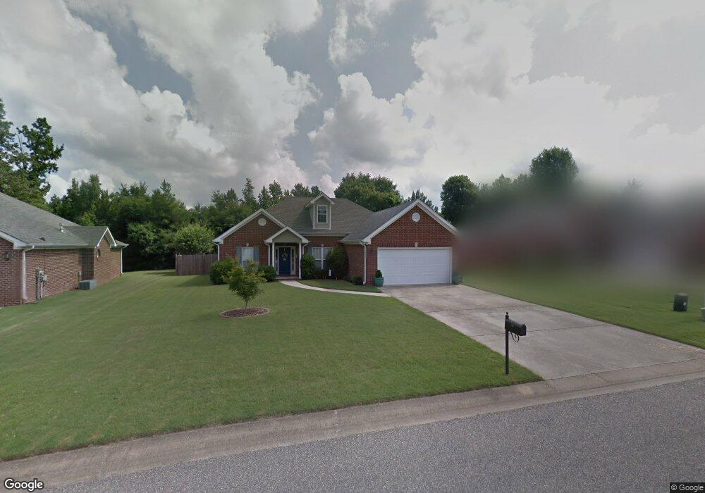
167 Cedar Grove Pkwy Maylene, AL 35114
Estimated Value: $262,000 - $295,000
3
Beds
2
Baths
1,552
Sq Ft
$180/Sq Ft
Est. Value
About This Home
This home is located at 167 Cedar Grove Pkwy, Maylene, AL 35114 and is currently estimated at $279,595, approximately $180 per square foot. 167 Cedar Grove Pkwy is a home located in Shelby County with nearby schools including Thompson Intermediate School, Thompson Middle School, and Thompson High School.
Ownership History
Date
Name
Owned For
Owner Type
Purchase Details
Closed on
Jul 10, 2020
Sold by
Todd Leslie B and Todd Daniel H
Bought by
Wright Carra L
Current Estimated Value
Home Financials for this Owner
Home Financials are based on the most recent Mortgage that was taken out on this home.
Original Mortgage
$184,300
Outstanding Balance
$163,425
Interest Rate
3.1%
Mortgage Type
New Conventional
Estimated Equity
$116,170
Purchase Details
Closed on
Apr 20, 2007
Sold by
Simpkins Joshua D and Simpkins Shawn N
Bought by
Todd Leslie B and Todd Daniel H
Home Financials for this Owner
Home Financials are based on the most recent Mortgage that was taken out on this home.
Original Mortgage
$148,117
Interest Rate
4.8%
Mortgage Type
VA
Purchase Details
Closed on
Aug 26, 1999
Sold by
Kent Larry
Bought by
Simpkins Joshua D and Tomlinson Shawn N
Home Financials for this Owner
Home Financials are based on the most recent Mortgage that was taken out on this home.
Original Mortgage
$128,600
Interest Rate
7.73%
Create a Home Valuation Report for This Property
The Home Valuation Report is an in-depth analysis detailing your home's value as well as a comparison with similar homes in the area
Home Values in the Area
Average Home Value in this Area
Purchase History
| Date | Buyer | Sale Price | Title Company |
|---|---|---|---|
| Wright Carra L | $194,000 | None Available | |
| Todd Leslie B | $145,000 | None Available | |
| Simpkins Joshua D | $132,600 | Magic City Title Company Inc |
Source: Public Records
Mortgage History
| Date | Status | Borrower | Loan Amount |
|---|---|---|---|
| Open | Wright Carra L | $184,300 | |
| Previous Owner | Todd Leslie B | $148,117 | |
| Previous Owner | Simpkins Joshua D | $128,600 |
Source: Public Records
Tax History Compared to Growth
Tax History
| Year | Tax Paid | Tax Assessment Tax Assessment Total Assessment is a certain percentage of the fair market value that is determined by local assessors to be the total taxable value of land and additions on the property. | Land | Improvement |
|---|---|---|---|---|
| 2024 | $1,271 | $23,540 | $0 | $0 |
| 2023 | $1,176 | $22,540 | $0 | $0 |
| 2022 | $1,090 | $20,940 | $0 | $0 |
| 2021 | $943 | $18,220 | $0 | $0 |
| 2020 | $837 | $16,260 | $0 | $0 |
| 2019 | $793 | $15,440 | $0 | $0 |
| 2017 | $728 | $14,240 | $0 | $0 |
| 2015 | $689 | $13,520 | $0 | $0 |
| 2014 | $690 | $13,540 | $0 | $0 |
Source: Public Records
Map
Nearby Homes
- 155 Victoria Station
- 236 Queens Gate
- 549 Ramsgate Dr
- 545 Ramsgate Dr
- 208 Queens Gate
- 501 Ramsgate Dr
- 306 Mayfair Cir
- 309 Cedar Grove Ct
- 217 Mayfair Park
- 537 Ramsgate Dr
- 233 Norwick Forest Dr
- 493 Ramsgate Dr
- 280 Cedar Grove Pkwy Unit 34
- 109 Kingsley Cir
- 220 Cedar Meadow
- 256 Cedar Meadow
- 217 Kensington Ln
- 128 Oak St
- 112 Kingsley Ct
- 104 Camden Cir
- 167 Cedar Grove Pkwy
- 163 Cedar Grove Pkwy
- 171 Cedar Grove Pkwy
- 175 Cedar Grove Pkwy
- 159 Cedar Grove Pkwy
- 159 Cedar Grove Pkwy
- 166 Cedar Grove Pkwy
- 170 Cedar Grove Pkwy
- 160 Cedar Grove Pkwy
- 113 Churchill Dr
- 179 Cedar Grove Pkwy
- 121 Churchill Dr
- 174 Cedar Grove Pkwy
- 117 Churchill Dr
- 109 Churchill Dr
- 109 Victoria Station
- 178 Cedar Grove Pkwy
- 125 Churchill Dr
- 151 Cedar Grove Pkwy
- 183 Cedar Grove Pkwy