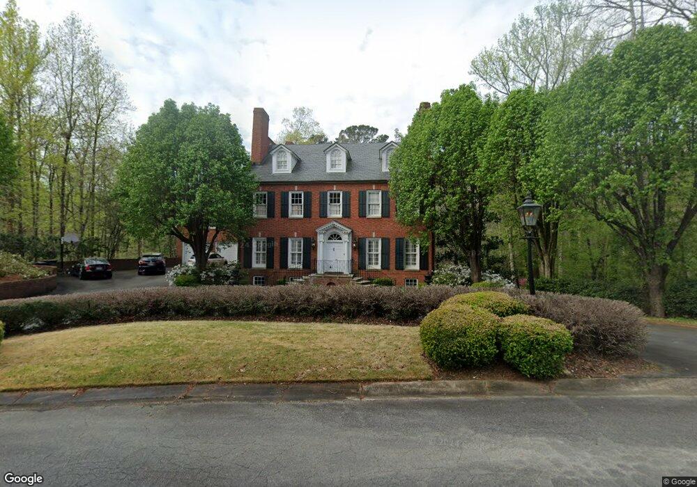
167 Covington Dr Macon, GA 31210
Estimated Value: $708,119 - $801,000
5
Beds
6
Baths
4,658
Sq Ft
$160/Sq Ft
Est. Value
About This Home
This home is located at 167 Covington Dr, Macon, GA 31210 and is currently estimated at $746,030, approximately $160 per square foot. 167 Covington Dr is a home located in Bibb County with nearby schools including Carter Elementary School, Howard Middle School, and Howard High School.
Ownership History
Date
Name
Owned For
Owner Type
Purchase Details
Closed on
Aug 1, 2023
Sold by
Cottle Brogdon Margaret
Bought by
Margaret Cottle Brogdon Revocable Trust and Brogdon
Current Estimated Value
Purchase Details
Closed on
Jun 30, 2023
Sold by
Brogdon Joseph M
Bought by
Cottle Brogdon Margaret
Purchase Details
Closed on
Dec 3, 2003
Bought by
Brogdon Joseph M
Create a Home Valuation Report for This Property
The Home Valuation Report is an in-depth analysis detailing your home's value as well as a comparison with similar homes in the area
Purchase History
| Date | Buyer | Sale Price | Title Company |
|---|---|---|---|
| Margaret Cottle Brogdon Revocable Trust | -- | None Listed On Document | |
| Cottle Brogdon Margaret | -- | None Listed On Document | |
| Brogdon Joseph M | -- | -- |
Source: Public Records
Tax History
| Year | Tax Paid | Tax Assessment Tax Assessment Total Assessment is a certain percentage of the fair market value that is determined by local assessors to be the total taxable value of land and additions on the property. | Land | Improvement |
|---|---|---|---|---|
| 2025 | $6,918 | $281,529 | $30,000 | $251,529 |
| 2024 | $7,150 | $281,529 | $30,000 | $251,529 |
| 2023 | $7,644 | $265,074 | $30,000 | $235,074 |
| 2022 | $6,882 | $205,784 | $22,741 | $183,043 |
| 2021 | $7,554 | $205,784 | $22,741 | $183,043 |
| 2020 | $7,718 | $205,784 | $22,741 | $183,043 |
| 2019 | $7,781 | $205,784 | $22,741 | $183,043 |
| 2018 | $12,097 | $205,784 | $22,741 | $183,043 |
| 2017 | $7,448 | $205,784 | $22,741 | $183,043 |
| 2016 | $6,877 | $205,784 | $22,741 | $183,043 |
| 2015 | $9,735 | $205,784 | $22,741 | $183,043 |
| 2014 | $3,250 | $205,784 | $22,741 | $183,043 |
Source: Public Records
Map
Nearby Homes
- 112 Covington Place
- 4860 Forsyth Rd
- 650 Crawford Rd
- 1183 Saint Andrews Dr
- 670 Middlesex Dr
- 5181 Zebulon Rd
- 428 Wesleyan Dr
- 4939 Guerry Dr
- 150 Tucker Rd
- 104 Troon Way
- 4811 Guerry Dr
- 605 Wesleyan Dr
- 120 Idle Hour Dr
- 113 Manor Row
- 230 Carriage Trail
- 208 Huntington Ct
- 4555 Old Club Rd
- 4716 Moor Park
- 211 Old Club Ct
- 163 Covington Dr
- 171 Covington Dr
- 170 Covington Dr
- 180 Covington Dr
- 160 Covington Dr
- 153 Covington Ct
- 150 Covington Dr
- 115 Covington Place Unit 35
- 116 Covington Place
- 5363 Yorktown Rd
- 111 Covington Place
- 141 Covington Ct
- 121 Covington Place
- 120 Covington Place
- 119 Covington Place
- 117 Covington Place
- 110 Covington Place
- 133 Covington Dr
- 124 Covington Place
- 122 Covington Place
Your Personal Tour Guide
Ask me questions while you tour the home.