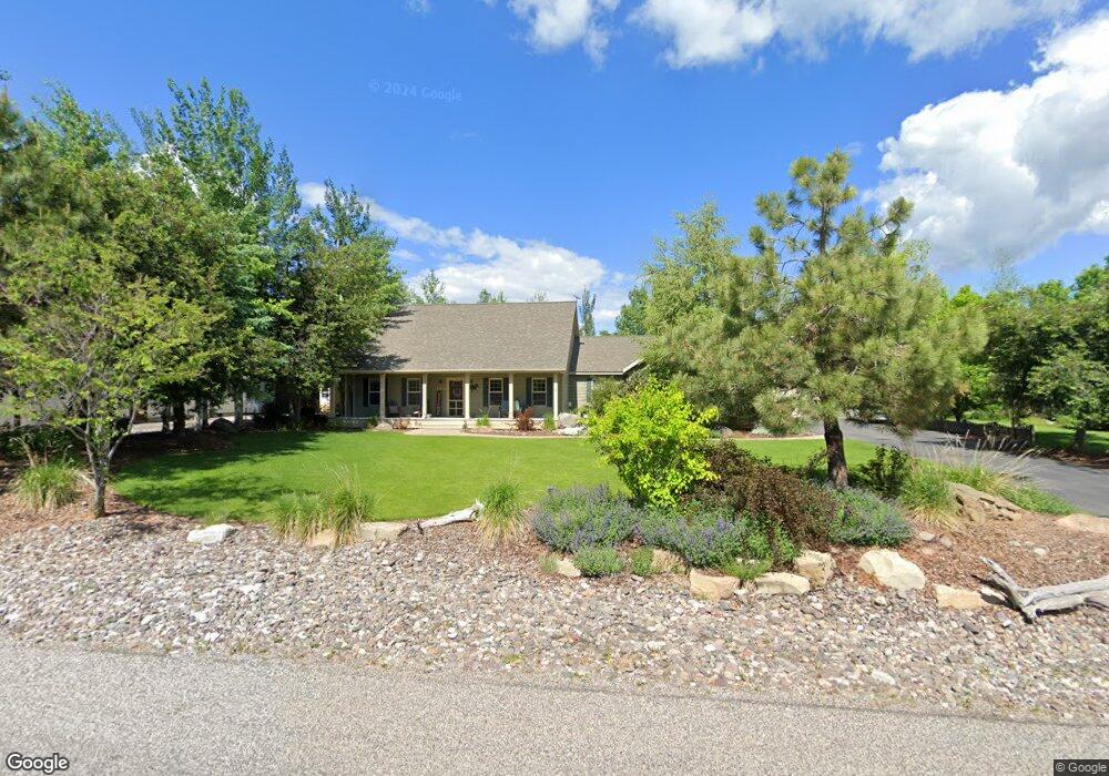
167 Old West Trail Bozeman, MT 59718
Estimated Value: $828,982 - $893,000
4
Beds
3
Baths
2,295
Sq Ft
$379/Sq Ft
Est. Value
About This Home
This home is located at 167 Old West Trail, Bozeman, MT 59718 and is currently estimated at $869,994, approximately $379 per square foot. 167 Old West Trail is a home located in Gallatin County with nearby schools including Heck/Quaw Elementary School and Belgrade High School.
Ownership History
Date
Name
Owned For
Owner Type
Purchase Details
Closed on
Dec 15, 2017
Sold by
Aasheim Deena
Bought by
Sigler Cody M and Sigler Erin M
Current Estimated Value
Home Financials for this Owner
Home Financials are based on the most recent Mortgage that was taken out on this home.
Original Mortgage
$424,100
Outstanding Balance
$357,055
Interest Rate
3.94%
Mortgage Type
New Conventional
Estimated Equity
$512,939
Purchase Details
Closed on
May 1, 2008
Sold by
Saunders Charles C
Bought by
Aasheim Erik and Aasheim Deena
Home Financials for this Owner
Home Financials are based on the most recent Mortgage that was taken out on this home.
Original Mortgage
$245,600
Interest Rate
5.81%
Mortgage Type
Purchase Money Mortgage
Purchase Details
Closed on
May 26, 2005
Sold by
Mabie Gordon W and Mabie Pat M
Bought by
Saunders Charles C and Saunders Lorraine
Create a Home Valuation Report for This Property
The Home Valuation Report is an in-depth analysis detailing your home's value as well as a comparison with similar homes in the area
Home Values in the Area
Average Home Value in this Area
Purchase History
| Date | Buyer | Sale Price | Title Company |
|---|---|---|---|
| Sigler Cody M | -- | Security Title Co | |
| Aasheim Erik | -- | American Land Title Company | |
| Saunders Charles C | -- | American Land Title Company |
Source: Public Records
Mortgage History
| Date | Status | Borrower | Loan Amount |
|---|---|---|---|
| Open | Sigler Cody M | $424,100 | |
| Previous Owner | Aasheim Erik | $245,600 |
Source: Public Records
Tax History Compared to Growth
Tax History
| Year | Tax Paid | Tax Assessment Tax Assessment Total Assessment is a certain percentage of the fair market value that is determined by local assessors to be the total taxable value of land and additions on the property. | Land | Improvement |
|---|---|---|---|---|
| 2025 | $3,542 | $857,400 | $0 | $0 |
| 2024 | $5,026 | $830,400 | $0 | $0 |
| 2023 | $5,008 | $830,400 | $0 | $0 |
| 2022 | $3,938 | $525,500 | $0 | $0 |
| 2021 | $3,978 | $525,500 | $0 | $0 |
| 2020 | $3,861 | $481,500 | $0 | $0 |
| 2019 | $3,932 | $481,500 | $0 | $0 |
| 2018 | $3,555 | $410,600 | $0 | $0 |
| 2017 | $3,323 | $394,000 | $0 | $0 |
| 2016 | $3,112 | $344,200 | $0 | $0 |
| 2015 | $2,900 | $344,200 | $0 | $0 |
| 2014 | $2,325 | $168,116 | $0 | $0 |
Source: Public Records
Map
Nearby Homes
- 604 Morrison Ave Unit B
- 11 Liberty Dr
- 9 Liberty Dr
- 6 Liberty Dr
- 13 Liberty Dr
- 5 Liberty Dr
- 16 Tailwater Dr
- 126 Pathfinder Trail
- 17 Tailwater Dr
- 370 Prospector Trail
- 19 Tailwater Dr
- 12 Pathfinder Trail
- 21 Tailwater Dr
- 283 Valley Grove Dr
- Lot 10 Riparian Way
- Lot 3 Riparian Way
- Lot 11 Riparian Way
- 25 Tailwater Dr
- 23 Tailwater Dr
- 339 Mountain Lion Trail
- 143 West Trail
- 143 Old West Trail
- 179 Old West Trail
- 245 Lewis And Clark Trail
- 166 Old West Trail
- 221 Lewis And Clark Trail
- 166 West Trail
- 142 Old West Trail
- 203 Old West Trail
- 121 Old West Trail
- 203 West Trail
- 219 Lewis And Clark Trail
- 178 Old West Trail
- 267 Lewis And Clark Trail
- 283 Lewis And Clark Trail
- 119 Lewis And Clark Trail
- 206 Old West Trail
- 237 Explorer Trail
- 225 West Trail
- 209 Explorer Trail