Estimated Value: $217,000 - $266,000
About This Home
Property Id: 192803
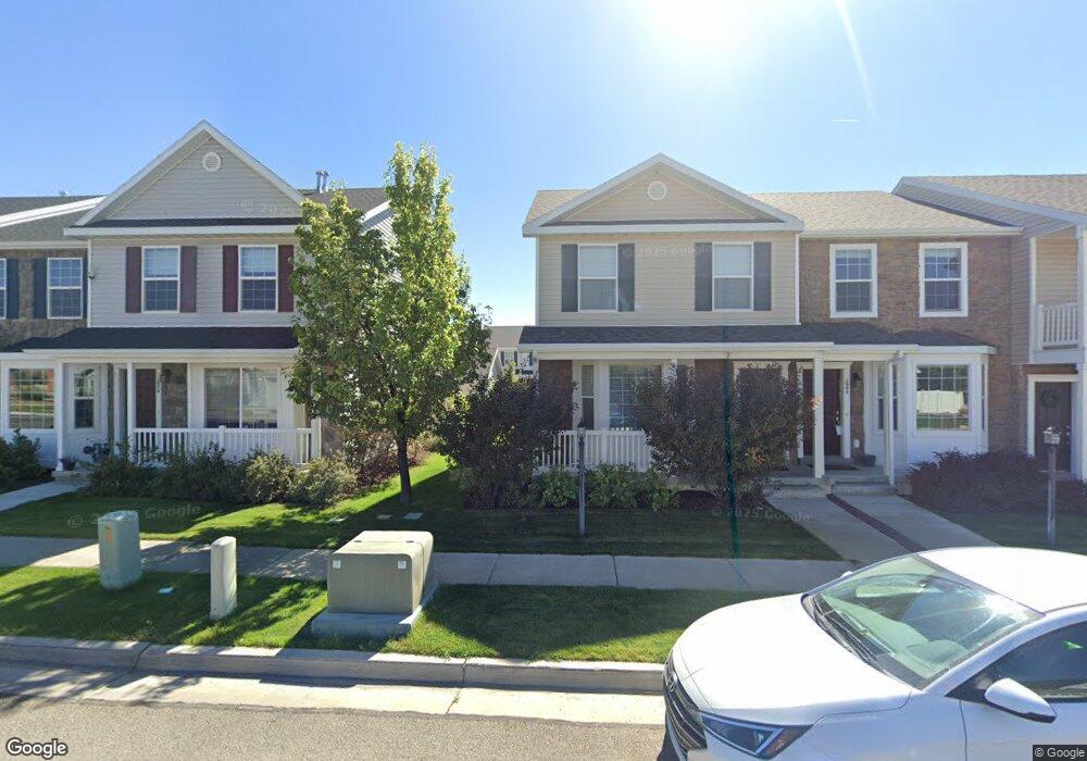
Beautiful Townhouse located in a new development on the East side of Price, UT. It is in a quiet neighborhood close to Castle Heights Elementary, and downtown shopping is a mile or two away. Close by are trails that canvas through the area's High Desert. Trails are open to off road vehicle, mtn bike, hiker, or horse. Home includes a private patio in the back. HOA takes care of all landscaping, watering, and snow removal (road, parking lot). Front porch and side walk is your responsibility.
- NO smoking, alcohol abuse, or us of illegal drugs. - All utilities paid by tenant and placed in their name - $1200 deposit. ($350 will not be refunded for carpet cleaning). Remaining refund is subject to exit home inspection.
Ownership History
Purchase Details
Home Financials for this Owner
Home Financials are based on the most recent Mortgage that was taken out on this home.Purchase Details
Home Financials for this Owner
Home Financials are based on the most recent Mortgage that was taken out on this home.Purchase Details
Home Financials for this Owner
Home Financials are based on the most recent Mortgage that was taken out on this home.Home Values in the Area
Average Home Value in this Area
Purchase History
| Date | Buyer | Sale Price | Title Company |
|---|---|---|---|
| Smith Paul K | -- | South Eastern Utah Title Co | |
| Auberger Tammy L | -- | South Eastern Utah Title Co | |
| Blocker Matthew J | -- | South Eastern Utah Title Com |
Mortgage History
| Date | Status | Borrower | Loan Amount |
|---|---|---|---|
| Open | Smith Paul K | $86,500 | |
| Previous Owner | Auberger Tammy L | $122,735 | |
| Previous Owner | Blocker Matthew J | $122,346 |
Property History
| Date | Event | Price | List to Sale | Price per Sq Ft |
|---|---|---|---|---|
| 10/15/2024 10/15/24 | For Rent | $1,100 | -- | -- |
Tax History Compared to Growth
Tax History
| Year | Tax Paid | Tax Assessment Tax Assessment Total Assessment is a certain percentage of the fair market value that is determined by local assessors to be the total taxable value of land and additions on the property. | Land | Improvement |
|---|---|---|---|---|
| 2025 | $1,390 | $114,407 | $6,820 | $107,587 |
| 2024 | $1,494 | $124,350 | $49,500 | $74,850 |
| 2023 | $1,421 | $126,166 | $21,077 | $105,089 |
| 2022 | $1,470 | $117,130 | $17,524 | $99,606 |
| 2021 | $1,278 | $158,008 | $26,775 | $131,233 |
| 2020 | $1,258 | $78,080 | $0 | $0 |
| 2019 | $1,127 | $73,315 | $0 | $0 |
| 2018 | $1,062 | $70,479 | $0 | $0 |
| 2017 | $1,049 | $70,479 | $0 | $0 |
| 2016 | $946 | $70,479 | $0 | $0 |
| 2015 | $946 | $70,479 | $0 | $0 |
| 2014 | $940 | $70,479 | $0 | $0 |
| 2013 | $1,079 | $80,126 | $0 | $0 |
Map
- 1689 Eastridge Rd
- 546 Windsor Rd
- 639 N 1550 E
- 703 N Windsor Cir
- 688 Birch Cir
- 1827 E 8th N Unit 79
- 1841 E 8th N Unit 78
- 831 N 1820 E Unit 66
- 1855 E 8th N Unit 77
- 1830 E 840 N Unit 80
- 1840 E 840 N Unit 81
- 1858 E 840 N Unit 82
- 1829 E 840 N Unit 87
- 349 Crestview Dr
- 1843 E 840 N Unit 86
- 824 N 1880 E Unit 74
- 1857 E 840 N Unit 85
- 879 N 1820 E Unit 69
- 838 N 1880 E Unit 73
- 1871 E 840 N Unit 84
- 1672 E 450 N Unit 13
- 1672 E 450 N
- 1678 E 450 N
- 1670 E 450 N
- 1670 E 450 N Unit 14
- 1662 E 450 N
- 1658 E 450 N
- 1654 E 450 N
- 1652 E 450 N
- 1674 Eastridge Rd
- 1684 Eastridge Rd
- 1660 Eastridge Rd
- 1676 Eastridge Rd
- 1680 Eastridge Rd Unit 2
- 1680 Eastridge Rd
- 1668 E Eastridge Rd N
- 1664 E 475 N
- 1660 E 475 N
- 1660 E 475 N Unit 7
- 1668 E 475 N