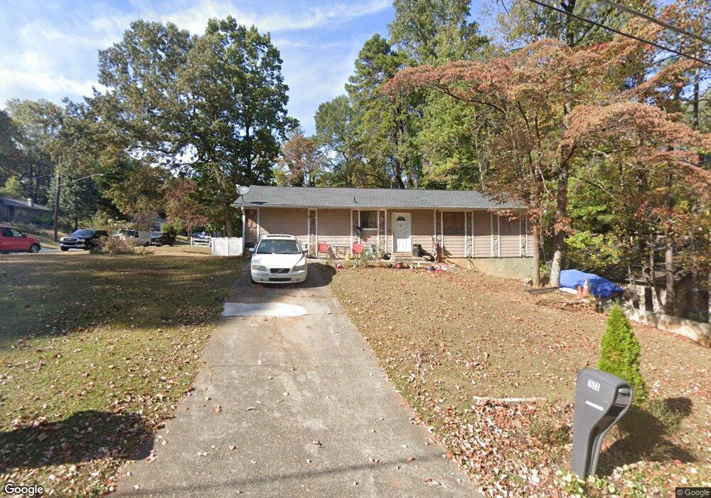
1674 Spender Dr Unit 2 Norcross, GA 30093
Estimated Value: $320,461 - $347,000
3
Beds
2
Baths
1,560
Sq Ft
$211/Sq Ft
Est. Value
About This Home
This home is located at 1674 Spender Dr Unit 2, Norcross, GA 30093 and is currently estimated at $329,365, approximately $211 per square foot. 1674 Spender Dr Unit 2 is a home located in Gwinnett County with nearby schools including Graves Elementary School, Louise Radloff Middle School, and Meadowcreek High School.
Ownership History
Date
Name
Owned For
Owner Type
Purchase Details
Closed on
Sep 19, 2024
Sold by
Amaya Maria C
Bought by
Amaya Ana Elizabeth and Hernandez Amaya Cristina
Current Estimated Value
Purchase Details
Closed on
Sep 1, 1999
Sold by
Richmond Willie E and Richmond Faye B
Bought by
Amaya Maria C
Home Financials for this Owner
Home Financials are based on the most recent Mortgage that was taken out on this home.
Original Mortgage
$95,092
Interest Rate
7.73%
Mortgage Type
FHA
Purchase Details
Closed on
Jun 25, 1993
Sold by
Lapsky Ray
Bought by
Richard Willie E Faye
Home Financials for this Owner
Home Financials are based on the most recent Mortgage that was taken out on this home.
Original Mortgage
$71,950
Interest Rate
7.52%
Mortgage Type
FHA
Create a Home Valuation Report for This Property
The Home Valuation Report is an in-depth analysis detailing your home's value as well as a comparison with similar homes in the area
Home Values in the Area
Average Home Value in this Area
Purchase History
| Date | Buyer | Sale Price | Title Company |
|---|---|---|---|
| Amaya Ana Elizabeth | -- | -- | |
| Amaya Maria C | $98,000 | -- | |
| Richard Willie E Faye | $72,000 | -- |
Source: Public Records
Mortgage History
| Date | Status | Borrower | Loan Amount |
|---|---|---|---|
| Previous Owner | Amaya Maria C | $95,092 | |
| Previous Owner | Richard Willie E Faye | $71,950 |
Source: Public Records
Tax History
| Year | Tax Paid | Tax Assessment Tax Assessment Total Assessment is a certain percentage of the fair market value that is determined by local assessors to be the total taxable value of land and additions on the property. | Land | Improvement |
|---|---|---|---|---|
| 2025 | $3,213 | $127,640 | $21,120 | $106,520 |
| 2024 | $3,182 | $120,440 | $21,120 | $99,320 |
| 2023 | $3,182 | $106,600 | $24,000 | $82,600 |
| 2022 | $2,072 | $69,120 | $19,200 | $49,920 |
| 2021 | $2,096 | $69,120 | $19,200 | $49,920 |
| 2020 | $2,048 | $66,240 | $14,560 | $51,680 |
| 2019 | $1,901 | $61,320 | $14,560 | $46,760 |
| 2018 | $1,720 | $53,120 | $12,000 | $41,120 |
| 2016 | $1,479 | $40,920 | $10,000 | $30,920 |
| 2015 | $1,263 | $31,840 | $7,200 | $24,640 |
| 2014 | -- | $31,840 | $7,200 | $24,640 |
Source: Public Records
Map
Nearby Homes
- 1807 Brookside Lay Cir
- 6419 Danbury Ln
- 6636 Witherington Ct
- 802 Olde Mill Ln
- 1563 Greenwood Dr
- 6711 Colchester Place
- 6715 Colchester Place
- 6694 Colchester Place
- 6727 Trafalger Square
- 6705 Witherington Ct NW
- 6716 Colchester Place
- 6718 Colchester Place Unit 205
- 6720 Colchester Place
- 306 Autumn Leaf Way
- 1626 Bussell Place
- 6267 Hayes Dr
- 6734 Graves Mill Dr
- 435 Seasons Pkwy
- 814 Seasons Pkwy
- 843 Seasons Pkwy
- 1666 Spender Dr
- 1667 Auden Ln
- 1658 Spender Dr
- 1658 Auden Ln Unit 2
- 1658 Auden Ln
- 1675 Auden Ln
- 1650 Auden Ln Unit 2
- 1666 Auden Ln
- 1673 Spender Dr Unit 2
- 1642 Auden Ln
- 1674 Auden Ln
- 1650 Spender Dr
- 1683 Auden Ln
- 1634 Auden Ln Unit 2
- 1682 Auden Ln Unit 2
- 0 Spender Dr Unit 3104951
- 0 Spender Dr Unit 3172242
- 0 Spender Dr Unit 7038104
- 0 Spender Dr Unit 7205059
- 6489 E Windsor Ln
Your Personal Tour Guide
Ask me questions while you tour the home.