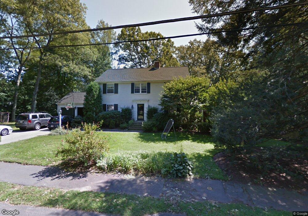
168 Bristol Rd Wellesley Hills, MA 02481
Cliff Estates NeighborhoodEstimated Value: $2,379,000 - $4,801,000
5
Beds
8
Baths
4,764
Sq Ft
$778/Sq Ft
Est. Value
About This Home
This home is located at 168 Bristol Rd, Wellesley Hills, MA 02481 and is currently estimated at $3,704,474, approximately $777 per square foot. 168 Bristol Rd is a home located in Norfolk County with nearby schools including Ernest F. Upham Elementary School, Wellesley Middle School, and Wellesley Sr High School.
Ownership History
Date
Name
Owned For
Owner Type
Purchase Details
Closed on
Aug 20, 2019
Sold by
Driscoll Scott D and Driscoll Sarah M
Bought by
Goldberg Brian D and Bonventre Joanna C
Current Estimated Value
Home Financials for this Owner
Home Financials are based on the most recent Mortgage that was taken out on this home.
Original Mortgage
$2,000,000
Outstanding Balance
$1,755,218
Interest Rate
3.8%
Mortgage Type
Purchase Money Mortgage
Estimated Equity
$1,949,256
Purchase Details
Closed on
Nov 16, 1998
Sold by
Salisbury Tr John W and Alisbury Robert W
Bought by
Driscoll Scott Dm and Driscoll Sarah M
Home Financials for this Owner
Home Financials are based on the most recent Mortgage that was taken out on this home.
Original Mortgage
$520,000
Interest Rate
6.65%
Mortgage Type
Purchase Money Mortgage
Create a Home Valuation Report for This Property
The Home Valuation Report is an in-depth analysis detailing your home's value as well as a comparison with similar homes in the area
Home Values in the Area
Average Home Value in this Area
Purchase History
| Date | Buyer | Sale Price | Title Company |
|---|---|---|---|
| Goldberg Brian D | $1,325,000 | -- | |
| Driscoll Scott Dm | $650,000 | -- |
Source: Public Records
Mortgage History
| Date | Status | Borrower | Loan Amount |
|---|---|---|---|
| Open | Goldberg Brian D | $2,000,000 | |
| Previous Owner | Driscoll Scott Dm | $25,000 | |
| Previous Owner | Driscoll Scott Dm | $72,000 | |
| Previous Owner | Driscoll Scott Dm | $520,000 |
Source: Public Records
Tax History Compared to Growth
Tax History
| Year | Tax Paid | Tax Assessment Tax Assessment Total Assessment is a certain percentage of the fair market value that is determined by local assessors to be the total taxable value of land and additions on the property. | Land | Improvement |
|---|---|---|---|---|
| 2025 | $38,519 | $3,747,000 | $1,402,000 | $2,345,000 |
| 2024 | $36,810 | $3,536,000 | $1,285,000 | $2,251,000 |
| 2023 | $38,987 | $3,405,000 | $1,122,000 | $2,283,000 |
| 2022 | $36,512 | $3,126,000 | $889,000 | $2,237,000 |
| 2021 | $26,344 | $2,242,000 | $889,000 | $1,353,000 |
| 2020 | $14,438 | $1,249,000 | $889,000 | $360,000 |
| 2019 | $14,451 | $1,249,000 | $889,000 | $360,000 |
| 2018 | $14,460 | $1,210,000 | $886,000 | $324,000 |
| 2017 | $14,254 | $1,209,000 | $885,000 | $324,000 |
| 2016 | $13,995 | $1,183,000 | $870,000 | $313,000 |
| 2015 | $13,722 | $1,187,000 | $871,000 | $316,000 |
Source: Public Records
Map
Nearby Homes
- 36 Oakridge Rd
- 201 Lowell Rd
- 18 Sprague Rd
- 209 Bristol Rd
- 15 Essex Rd
- 16 Stearns Rd Unit 101
- 16 Stearns Rd Unit 302
- 16 Stearns Rd Unit 207
- 16 Stearns Rd Unit 301
- 16 Stearns Rd Unit 103
- 16 Stearns Rd Unit 202
- 16 Stearns Rd Unit 304
- 16 Stearns Rd Unit 104
- 16 Stearns Rd Unit 108
- 6 Norwich Rd
- 39 Audubon Rd
- 63 Oak St Unit B
- 6 Nantucket Rd
- 7 Mountview Rd
- 42 Calvin Rd
- 174 Bristol Rd
- 29 Oakridge Rd
- 29 Oakridge Rd
- 5 Oakridge Rd
- 9 Oakridge Rd
- 4 Wynnewood Rd
- 175 Bristol Rd
- 23 Oakridge Rd
- 33 Oakridge Rd
- 178 Bristol Rd
- 8 Wynnewood Rd
- 179 Bristol Rd
- 157 Bristol Rd
- 158 Bristol Rd
- 158 Bristol Rd Unit 158
- 37 Oakridge Rd
- 30 Oakridge Rd
- 26 Oakridge Rd
- 10 Oakridge Rd
- 182 Bristol Rd