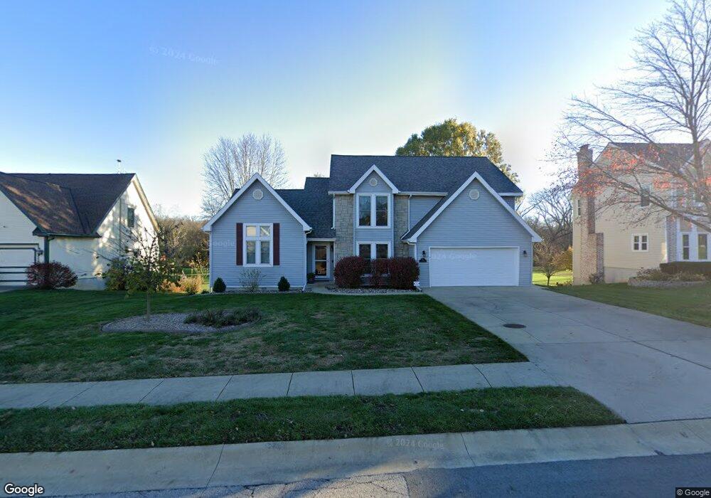
168 Canyon View Dr Lansing, KS 66043
Estimated Value: $403,359 - $452,000
4
Beds
3
Baths
2,528
Sq Ft
$166/Sq Ft
Est. Value
About This Home
This home is located at 168 Canyon View Dr, Lansing, KS 66043 and is currently estimated at $420,840, approximately $166 per square foot. 168 Canyon View Dr is a home located in Leavenworth County with nearby schools including Lansing Elementary School, Lansing Middle 6-8, and Lansing High 9-12.
Ownership History
Date
Name
Owned For
Owner Type
Purchase Details
Closed on
Dec 1, 1993
Bought by
Stroup Timothy J and Stroup Shelly K
Current Estimated Value
Home Financials for this Owner
Home Financials are based on the most recent Mortgage that was taken out on this home.
Original Mortgage
$148,500
Outstanding Balance
$97,523
Interest Rate
7.31%
Mortgage Type
New Conventional
Estimated Equity
$323,317
Create a Home Valuation Report for This Property
The Home Valuation Report is an in-depth analysis detailing your home's value as well as a comparison with similar homes in the area
Home Values in the Area
Average Home Value in this Area
Purchase History
| Date | Buyer | Sale Price | Title Company |
|---|---|---|---|
| Stroup Timothy J | $161,000 | -- |
Source: Public Records
Mortgage History
| Date | Status | Borrower | Loan Amount |
|---|---|---|---|
| Open | Stroup Timothy J | $148,500 |
Source: Public Records
Tax History Compared to Growth
Tax History
| Year | Tax Paid | Tax Assessment Tax Assessment Total Assessment is a certain percentage of the fair market value that is determined by local assessors to be the total taxable value of land and additions on the property. | Land | Improvement |
|---|---|---|---|---|
| 2025 | $5,466 | $42,135 | $4,216 | $37,919 |
| 2024 | $5,080 | $40,515 | $4,216 | $36,299 |
| 2023 | $5,080 | $39,054 | $4,216 | $34,838 |
| 2022 | $4,828 | $35,098 | $3,168 | $31,930 |
| 2021 | $4,819 | $33,430 | $3,168 | $30,262 |
| 2020 | $4,406 | $30,101 | $3,168 | $26,933 |
| 2019 | $4,163 | $28,422 | $3,168 | $25,254 |
| 2018 | $3,999 | $27,328 | $3,168 | $24,160 |
| 2017 | $3,891 | $26,533 | $3,168 | $23,365 |
| 2016 | $3,893 | $26,533 | $3,168 | $23,365 |
| 2015 | $3,881 | $26,533 | $3,168 | $23,365 |
| 2014 | $3,801 | $26,533 | $3,168 | $23,365 |
Source: Public Records
Map
Nearby Homes
- 875 Clearview Dr
- 866 Clearview Dr
- 833 Rock Creek Dr
- 1322 Rock Creek Ct
- 1221 S Desoto Rd
- 24431 139th St
- 13965 Mc Intyre Rd
- 922 Southfork St
- 13788 McIntyre1 Rd
- 13788 Mcintyre Rd
- 13788 McIntyre2 Rd
- 811 4-H Rd
- 000 4-H Rd
- 527 S Valley Dr
- 104 Olive St
- 522 Forestglen Ln
- 24303 131st St
- 546 Hithergreen Dr
- 202 S Main St
- 124 S Main St
- 170 Canyon View Dr
- 201 Cottonwood Dr
- 203 Cottonwood Dr
- 181 Canyon View Dr
- 200 Cottonwood Dr
- 183 Canyon View Dr
- 205 Cottonwood Dr
- 174 Canyon View Dr
- 202 Cottonwood Dr
- 210 Southfork Rd
- 185 Canyon View Dr
- 207 Cottonwood Dr
- 211 Southfork Rd
- 204 Cottonwood Dr
- 176 Canyon View Dr
- 187 Canyon View Dr
- 208 Southfork Rd
- 209 Southfork Rd
- 600 Cottonwood Dr
- 601 Cottonwood Dr