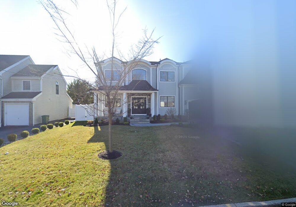
168 Reid Way Paramus, NJ 07652
Estimated Value: $1,754,000 - $2,058,000
6
Beds
6
Baths
3,350
Sq Ft
$572/Sq Ft
Est. Value
About This Home
This home is located at 168 Reid Way, Paramus, NJ 07652 and is currently estimated at $1,916,359, approximately $572 per square foot. 168 Reid Way is a home located in Bergen County with nearby schools including Paramus High School, Alpine Learning Group, and Paramus Catholic High School.
Ownership History
Date
Name
Owned For
Owner Type
Purchase Details
Closed on
Dec 22, 2021
Sold by
Custodio Patrick P and Custodio Michelle P
Bought by
Custodio Family Trust
Current Estimated Value
Purchase Details
Closed on
Sep 22, 2021
Sold by
Andy Property Investment Llc
Bought by
Custodio Patrick and Custodio Michelle
Home Financials for this Owner
Home Financials are based on the most recent Mortgage that was taken out on this home.
Original Mortgage
$1,490,000
Interest Rate
2.8%
Mortgage Type
New Conventional
Purchase Details
Closed on
Oct 19, 2020
Sold by
Spoleti Joseph and Spoleti Stephanie M
Bought by
Andy Property Investment Llc
Purchase Details
Closed on
Nov 6, 2019
Sold by
168 Reid Way Llc
Bought by
Spoleti Joseph and Spoleti Stephanie
Purchase Details
Closed on
Aug 2, 2019
Sold by
Peck Mary F
Bought by
168 Reid Way Llc
Create a Home Valuation Report for This Property
The Home Valuation Report is an in-depth analysis detailing your home's value as well as a comparison with similar homes in the area
Home Values in the Area
Average Home Value in this Area
Purchase History
| Date | Buyer | Sale Price | Title Company |
|---|---|---|---|
| Custodio Family Trust | -- | Milvidskiy Law Group Pc | |
| Custodio Patrick | $1,490,000 | Builders Title Agency Inc | |
| Custodio Patrick | $1,490,000 | Builders Title | |
| Andy Property Investment Llc | $562,000 | First American Title Ins Co | |
| Spoleti Joseph | $525,000 | None Available | |
| 168 Reid Way Llc | $440,000 | -- |
Source: Public Records
Mortgage History
| Date | Status | Borrower | Loan Amount |
|---|---|---|---|
| Previous Owner | Custodio Patrick | $1,490,000 |
Source: Public Records
Tax History Compared to Growth
Tax History
| Year | Tax Paid | Tax Assessment Tax Assessment Total Assessment is a certain percentage of the fair market value that is determined by local assessors to be the total taxable value of land and additions on the property. | Land | Improvement |
|---|---|---|---|---|
| 2025 | $22,899 | $1,608,600 | $392,000 | $1,216,600 |
| 2024 | $23,101 | $1,512,500 | $357,700 | $1,154,800 |
| 2023 | $21,903 | $1,505,900 | $340,500 | $1,165,400 |
| 2022 | $21,903 | $1,411,300 | $317,300 | $1,094,000 |
| 2021 | $8,468 | $512,100 | $288,000 | $224,100 |
| 2020 | $8,047 | $504,500 | $283,000 | $221,500 |
| 2019 | $7,320 | $394,400 | $253,000 | $141,400 |
| 2018 | $7,229 | $394,400 | $253,000 | $141,400 |
| 2017 | $7,103 | $394,400 | $253,000 | $141,400 |
| 2016 | $6,910 | $394,400 | $253,000 | $141,400 |
| 2015 | $6,589 | $394,400 | $253,000 | $141,400 |
| 2014 | $6,530 | $394,400 | $253,000 | $141,400 |
Source: Public Records
Map
Nearby Homes
- 605 Craig Ave
- 648 Falmouth Ave
- 83 Birchwood Rd
- 602 Mill Run
- 133 Morristown Place
- 265 Purdue Ct
- 232 W Midland Ave
- 495 Paramus Rd
- 660 Arcadia Rd
- 101 Glen Ave
- 12 Pershing Ave
- 479 S Pleasant Ave
- 522 Grove St
- 33 Oliver Rd
- 827 Alden Rd
- 338 S van Dien Ave
- 683 Eastern Ct
- 11 Gabriel Ct
- 12 Gabriel Ct
- 16 Gabriel Ct