Estimated Value: $187,000 - $399,000
4
Beds
1
Bath
2,628
Sq Ft
$113/Sq Ft
Est. Value
About This Home
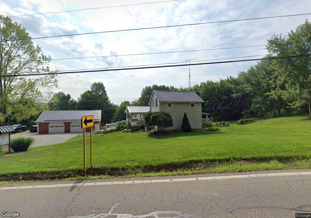
This home is located at 1695 State Route 603, Lucas, OH 44843 and is currently estimated at $296,285, approximately $112 per square foot. 1695 State Route 603 is a home located in Richland County with nearby schools including Lucas Elementary School, Lucas Heritage Middle School, and Lucas High School.
Ownership History
Date
Name
Owned For
Owner Type
Purchase Details
Closed on
Jun 4, 2025
Sold by
Carsey Angel L
Bought by
Carsey Donald C and Carsey Angel L
Current Estimated Value
Purchase Details
Closed on
Aug 13, 2024
Sold by
Carsey Donald C
Bought by
Carsey Angel L
Purchase Details
Closed on
Feb 20, 2004
Sold by
Longbeach Mortgage Co
Bought by
Carsey Donald and Carsey Angel L
Home Financials for this Owner
Home Financials are based on the most recent Mortgage that was taken out on this home.
Original Mortgage
$62,000
Interest Rate
4.2%
Mortgage Type
Purchase Money Mortgage
Purchase Details
Closed on
Jul 26, 1993
Sold by
Boggs Joseph
Bought by
Boggs Mark
Create a Home Valuation Report for This Property
The Home Valuation Report is an in-depth analysis detailing your home's value as well as a comparison with similar homes in the area
Home Values in the Area
Average Home Value in this Area
Purchase History
| Date | Buyer | Sale Price | Title Company |
|---|---|---|---|
| Carsey Donald C | -- | None Listed On Document | |
| Carsey Angel L | -- | None Listed On Document | |
| Carsey Donald | $78,700 | Chicago Title | |
| Boggs Mark | -- | -- |
Source: Public Records
Mortgage History
| Date | Status | Borrower | Loan Amount |
|---|---|---|---|
| Previous Owner | Carsey Donald | $62,000 |
Source: Public Records
Tax History Compared to Growth
Tax History
| Year | Tax Paid | Tax Assessment Tax Assessment Total Assessment is a certain percentage of the fair market value that is determined by local assessors to be the total taxable value of land and additions on the property. | Land | Improvement |
|---|---|---|---|---|
| 2024 | $2,059 | $61,820 | $26,450 | $35,370 |
| 2023 | $2,059 | $61,820 | $26,450 | $35,370 |
| 2022 | $1,952 | $51,250 | $20,310 | $30,940 |
| 2021 | $1,956 | $51,250 | $20,310 | $30,940 |
| 2020 | $1,988 | $51,250 | $20,310 | $30,940 |
| 2019 | $1,916 | $43,490 | $17,220 | $26,270 |
| 2018 | $1,972 | $43,490 | $17,220 | $26,270 |
| 2017 | $1,985 | $43,490 | $17,220 | $26,270 |
| 2016 | $2,105 | $40,100 | $13,260 | $26,840 |
| 2015 | $2,105 | $40,100 | $13,260 | $26,840 |
| 2014 | $2,115 | $40,100 | $13,260 | $26,840 |
| 2012 | $927 | $40,100 | $13,260 | $26,840 |
Source: Public Records
Map
Nearby Homes
- 0 Applegate Rd
- 0 Mount Zion Rd Unit 9069748
- 2428 Applegate Rd
- 27 E Main St
- 0 Moffett Rd
- 174 W Main St
- 3386 Trumpower Rd
- 3261 Moffett Rd
- 1048 Township Road 2156
- 68.40 Acres Trumpower Rd
- 0 Trumpower Rd
- 2905 Tucker Rd
- 968 Township Road 2506
- 0 Peterson Rd
- 2750 Lutz Ave
- 0 Township Road 925
- 1679 Pulver Rd
- 2221 Pleasant Valley Rd
- 19 Maine St
- 1183 County Road 30a
- 1661 State Route 603
- 1629 State Route 603
- 1694 State Route 603
- 1694 Ohio 603
- 1723 State Route 603
- 1726 State Route 603
- 1692 Ohio 603
- 1692 State Route 603
- 1744 State Route 603
- 3729 State Route 39
- 3771 State Route 39
- 1642 State Route 603
- 3789 State Route 39
- 3665 State Route 39
- 1600 State Route 603
- 1600 State Route 603
- 3649 State Route 39
- 3643 State Route 39
- 3643 Ohio 39
- 3635 State Route 39