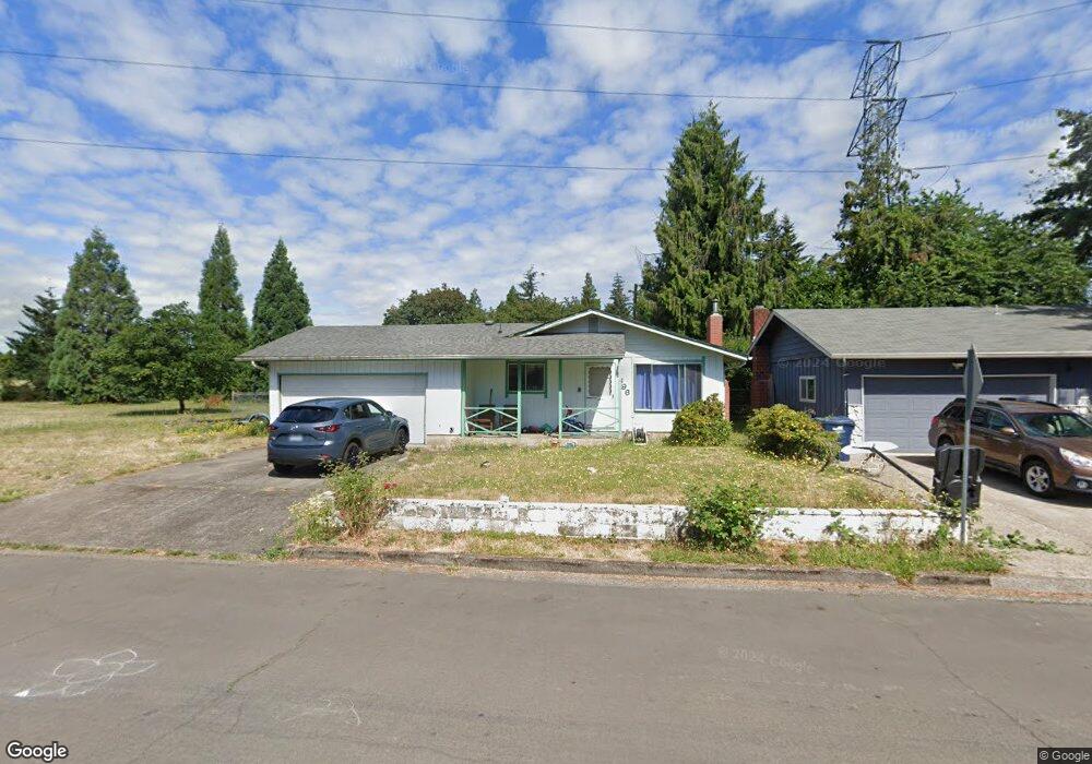
1696 W Quinalt St Springfield, OR 97477
West Springfield NeighborhoodEstimated Value: $358,434 - $405,000
3
Beds
1
Bath
1,134
Sq Ft
$333/Sq Ft
Est. Value
About This Home
This home is located at 1696 W Quinalt St, Springfield, OR 97477 and is currently estimated at $377,609, approximately $332 per square foot. 1696 W Quinalt St is a home located in Lane County with nearby schools including Centennial Elementary School, Hamlin Middle School, and Springfield High School.
Ownership History
Date
Name
Owned For
Owner Type
Purchase Details
Closed on
Jan 20, 2020
Sold by
Mayfield Harley L and Mayfield Cleta Jo
Bought by
Mayfield Harley L and Harley L Mayfield Revocable Li
Current Estimated Value
Purchase Details
Closed on
Aug 25, 2010
Sold by
Mayfield Harley L
Bought by
Mayfield Harley L and Mayfield Daisianna
Home Financials for this Owner
Home Financials are based on the most recent Mortgage that was taken out on this home.
Original Mortgage
$54,700
Outstanding Balance
$35,984
Interest Rate
4.52%
Mortgage Type
New Conventional
Estimated Equity
$341,625
Purchase Details
Closed on
May 15, 2006
Sold by
Mayfield Harley L
Bought by
Mayfield Harley L and Sammie L Mayfield Family Trust
Purchase Details
Closed on
Jun 16, 1998
Sold by
Or Dept Of Veterans Affairs
Bought by
Mayfield Harley L and Mayfield Sammie L
Create a Home Valuation Report for This Property
The Home Valuation Report is an in-depth analysis detailing your home's value as well as a comparison with similar homes in the area
Home Values in the Area
Average Home Value in this Area
Purchase History
| Date | Buyer | Sale Price | Title Company |
|---|---|---|---|
| Mayfield Harley L | -- | None Available | |
| Mayfield Harley L | -- | First American Title | |
| Mayfield Harley L | -- | None Available | |
| Mayfield Harley L | $46,500 | Western Pioneer Title |
Source: Public Records
Mortgage History
| Date | Status | Borrower | Loan Amount |
|---|---|---|---|
| Open | Mayfield Harley L | $54,700 |
Source: Public Records
Tax History Compared to Growth
Tax History
| Year | Tax Paid | Tax Assessment Tax Assessment Total Assessment is a certain percentage of the fair market value that is determined by local assessors to be the total taxable value of land and additions on the property. | Land | Improvement |
|---|---|---|---|---|
| 2025 | $2,719 | $185,607 | -- | -- |
| 2024 | $2,645 | $180,201 | -- | -- |
| 2023 | $2,645 | $174,953 | $0 | $0 |
| 2022 | $2,514 | $169,858 | $0 | $0 |
| 2021 | $2,460 | $164,911 | $0 | $0 |
| 2020 | $2,389 | $160,108 | $0 | $0 |
| 2019 | $2,305 | $155,445 | $0 | $0 |
| 2018 | $2,217 | $146,522 | $0 | $0 |
| 2017 | $2,151 | $146,522 | $0 | $0 |
| 2016 | $2,103 | $142,254 | $0 | $0 |
| 2015 | $2,052 | $138,111 | $0 | $0 |
| 2014 | $1,965 | $134,088 | $0 | $0 |
Source: Public Records
Map
Nearby Homes
- 1310 W Quinalt St
- 1130 Anderson Ln
- 1120 W Fairview Dr Unit 3
- 1770 Brandy Way
- 1632 Dotie Dr
- 1723 Dotie Dr
- 955 Oak Meadows Place
- 872 W N St
- 511 Panda Loop
- 3460 Oxbow Way
- 835 Anderson Ln
- 3515 Regent Ave
- 804 W N St
- 1267 Kenray Loop
- 511 Honeysuckle Ln
- 633 Rowan Ave
- 293 Roan Dr
- 484 Scotts Glen Dr
- 280 Roan Dr
- 436 W M St
- 1680 W Quinalt St
- 1693 W Quinalt St
- 1664 W Quinalt St
- 1615 Anderson Ln
- 1669 Linden Ave
- 1710 Linden Ave
- 1700 Linden Ave
- 1648 W Quinalt St
- 1545 Anderson Ln Unit VRM
- 1545 Anderson Ln
- 1645 Linden Ave
- 1682 Linden Ave
- 1632 W Quinalt St
- 1619 W Quinalt St
- 1670 Linden Ave
- 1521 Anderson Ln
- 1583 W Fairview Dr
- 1616 W Quinalt St
- 1635 Linden Ave
- 1620 Linden Ave