
17 Angus Ave South Yarmouth, MA 02664
South Yarmouth NeighborhoodEstimated payment $1,285/month
Highlights
- 0.92 Acre Lot
- No HOA
- Property is near shops
- Wooded Lot
- Additional Land
About This Lot
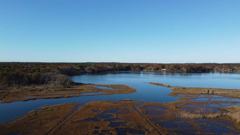
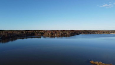
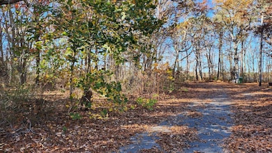
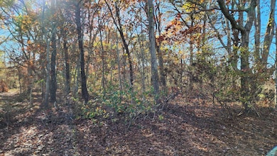
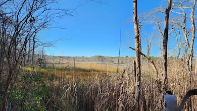
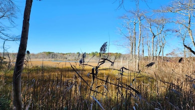
17 ANGUS AVE SOUTH YARMOUTH MA. VIEW OF PARKERS RIVER. 40,250 SQ. FT. LOT. BY PURCHASING 17 AND 27 ANGUS AVE THE COMBINED AREA IS 1.53 ACRES. BOTH LOTS OVERLOOK PARKERS RIVER AND MARSHLAND. YARMOUTH CONSERVATION DEPARTMENT HAS APPROVED CONSTRUCTION OF DWELLINGS ON BOTH LOTS. THE LAND HAS NO WETLANDS. COMBINING THE LOTS ALLOWS FOR CONSTRUCTION OF A THREE OR FOUR STORY BUILDING WHICH COULD CONTAIN TWENTY FOUR UNITS. A UNIQUE OPORTUNITY FOR A DEVELOPER OR INVESTOR. SURVEY, SITE AND CONCEPT PLANS ARE AVAILABLE. FAVORABLE OPTIONS AVAILABLE UNDER YARMOUTH ZONING V.C.O.D. ATTENTION!! PURCHASE PRICE FOR #17 ANGUS AVE, NOT INCLUDNG #27 ANGUS AVE, IS $224,900. SEE LISTING FOR #27 ANGUS AVE SOUTH YARMOUTH MA.
Property Details
Property Type
- Land
Est. Annual Taxes
- $1,259
Lot Details
- 0.92 Acre Lot
- Property fronts a private road
- Street terminates at a dead end
- Partial filled lot needs fill
- Wooded Lot
- Additional Land
- Property is zoned B-2
Location
- Property is near place of worship
- Property is near shops
Utilities
- Cable TV Available
Listing and Financial Details
- Assessor Parcel Number YARM M:0033 B:041.2 L:0000
Community Details
Overview
- No Home Owners Association
Recreation
- Electricity Available at Street
Map
Home Values in the Area
Average Home Value in this Area
Tax History
| Year | Tax Paid | Tax Assessment Tax Assessment Total Assessment is a certain percentage of the fair market value that is determined by local assessors to be the total taxable value of land and additions on the property. | Land | Improvement |
|---|---|---|---|---|
| 2025 | $1,124 | $158,800 | $158,800 | $0 |
| 2024 | $1,235 | $167,300 | $167,300 | $0 |
| 2023 | $1,209 | $149,100 | $149,100 | $0 |
| 2022 | $1,230 | $134,000 | $134,000 | $0 |
| 2021 | $1,281 | $134,000 | $134,000 | $0 |
| 2020 | $1,339 | $133,900 | $133,900 | $0 |
| 2019 | $1,352 | $133,900 | $133,900 | $0 |
| 2018 | $1,123 | $109,100 | $109,100 | $0 |
| 2017 | $1,093 | $109,100 | $109,100 | $0 |
| 2016 | $990 | $99,200 | $99,200 | $0 |
| 2015 | $996 | $99,200 | $99,200 | $0 |
Property History
| Date | Event | Price | List to Sale | Price per Sq Ft |
|---|---|---|---|---|
| 11/10/2025 11/10/25 | For Sale | $224,900 | -- | -- |
Source: Cape Cod & Islands Association of REALTORS®
MLS Number: 22505577
APN: YARM-000033-000041-020000
Disclaimer: Certain information contained herein is derived from information provided by parties other than Homes.com. All information provided is deemed reliable, but is not guaranteed to be accurate and should be independently verified.
![]() All data relating to real estate for sale on this page comes from the Broker Reciprocity (BR) of the Cape Cod & Islands Multiple Listing Service, Inc. Detailed information about real estate listings held by brokerage firms other than CC&I Assoc. of REALTORS®, Inc. includes the name of the listing company. Neither the listing company nor CC&I Assoc. of REALTORS®, Inc. shall be responsible for any typographical errors, misinformation, misprints and shall be held totally harmless. The Broker providing this data believes it to be correct, but advises interested parties to confirm any item before relying on it in a purchase decision. All properties are subject to prior sale, changes, or withdrawal. Copyright 2025 © Cape Cod & Islands Multiple Listing Service, Inc. All rights reserved.
All data relating to real estate for sale on this page comes from the Broker Reciprocity (BR) of the Cape Cod & Islands Multiple Listing Service, Inc. Detailed information about real estate listings held by brokerage firms other than CC&I Assoc. of REALTORS®, Inc. includes the name of the listing company. Neither the listing company nor CC&I Assoc. of REALTORS®, Inc. shall be responsible for any typographical errors, misinformation, misprints and shall be held totally harmless. The Broker providing this data believes it to be correct, but advises interested parties to confirm any item before relying on it in a purchase decision. All properties are subject to prior sale, changes, or withdrawal. Copyright 2025 © Cape Cod & Islands Multiple Listing Service, Inc. All rights reserved.
- 27 Angus Ave
- 26 Howes Rd
- 844 Route 28 Unit 2A
- 844 Route 28 Unit 9B
- 844 Route 28 Unit 2A
- 8 Rogers Ave
- 55 Pawkannawkut Dr
- 109 Seaview Ave Unit 11
- 54 Boxberry Ln
- 2 Candlewood Ln
- 33 Lake Rd
- 274 Winslow Gray Rd
- 3 Andy Ln
- 21 Lyndale Rd
- 23 Circuit Rd N
- 68 Bob-O-link Ln
- 9 Cedar St
- 4 Braddock St
- 11 Bob-O-link Ln
- 135 S South Shore Dr Unit 17
- 51 Ocean Ave Unit 103
- 28 Swan Lake Rd
- 166 Seaview Ave Unit 2a
- 80 Mattakese Rd Unit 7
- 483 Route 28
- 12 Town Hall Ave
- 40 Bradford Rd
- 7 Columbus Ave
- 6 Lauries Ln
- 45 Bernard St
- 35 Arlington St
- 13 Railway Bluff Unit 2nd floor
- 60 Pleasant St Unit 3B
- 215 W Main St
- 40 Pleasant St
- 27 Pleasant St
- 500 Ocean St
- 42 North St Unit 4
- 42 North St Unit 7
- 32 Washington Avenue Extension
