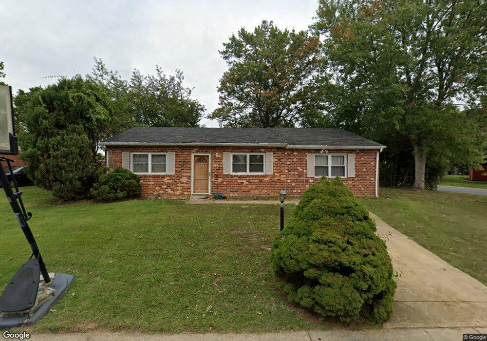
17 Burns Way Newark, DE 19702
Estimated Value: $251,000 - $311,000
3
Beds
1
Bath
1,263
Sq Ft
$224/Sq Ft
Est. Value
About This Home
This home is located at 17 Burns Way, Newark, DE 19702 and is currently estimated at $283,097, approximately $224 per square foot. 17 Burns Way is a home located in New Castle County with nearby schools including Jones (Albert H.) Elementary School, Christiana High School, and Shue-Medill Middle School.
Ownership History
Date
Name
Owned For
Owner Type
Purchase Details
Closed on
Nov 23, 2005
Sold by
Cooper Brett T
Bought by
Henderson Brandi
Current Estimated Value
Home Financials for this Owner
Home Financials are based on the most recent Mortgage that was taken out on this home.
Original Mortgage
$169,900
Outstanding Balance
$93,205
Interest Rate
6.06%
Mortgage Type
New Conventional
Estimated Equity
$189,892
Purchase Details
Closed on
Sep 12, 2003
Sold by
Cooper Brett T and Cooper Crystal R
Bought by
Cooper Brett T
Home Financials for this Owner
Home Financials are based on the most recent Mortgage that was taken out on this home.
Original Mortgage
$106,000
Interest Rate
4.75%
Mortgage Type
Purchase Money Mortgage
Create a Home Valuation Report for This Property
The Home Valuation Report is an in-depth analysis detailing your home's value as well as a comparison with similar homes in the area
Home Values in the Area
Average Home Value in this Area
Purchase History
| Date | Buyer | Sale Price | Title Company |
|---|---|---|---|
| Henderson Brandi | $84,950 | -- | |
| Cooper Brett T | -- | -- |
Source: Public Records
Mortgage History
| Date | Status | Borrower | Loan Amount |
|---|---|---|---|
| Open | Henderson Brandi | $169,900 | |
| Previous Owner | Cooper Brett T | $106,000 |
Source: Public Records
Tax History
| Year | Tax Paid | Tax Assessment Tax Assessment Total Assessment is a certain percentage of the fair market value that is determined by local assessors to be the total taxable value of land and additions on the property. | Land | Improvement |
|---|---|---|---|---|
| 2024 | $1,775 | $40,400 | $8,500 | $31,900 |
| 2023 | $1,729 | $40,400 | $8,500 | $31,900 |
| 2022 | $1,717 | $40,400 | $8,500 | $31,900 |
| 2021 | $1,680 | $40,400 | $8,500 | $31,900 |
| 2020 | $1,634 | $40,400 | $8,500 | $31,900 |
| 2019 | $1,513 | $40,400 | $8,500 | $31,900 |
| 2018 | $1,417 | $40,400 | $8,500 | $31,900 |
| 2017 | $1,368 | $40,400 | $8,500 | $31,900 |
| 2016 | $1,357 | $40,400 | $8,500 | $31,900 |
| 2015 | $1,241 | $40,400 | $8,500 | $31,900 |
| 2014 | $1,242 | $40,400 | $8,500 | $31,900 |
Source: Public Records
Map
Nearby Homes
- 7 Poe Way
- 34 Archer Cir
- 33 Pepperwood Ln
- 241 1/2 Smalleys Dam Rd
- 221 Gladstone Way
- 115 E Beaver Ct
- 44 Denny Cir
- 9 Creek Ln
- 238 Gladstone Way
- 244 Gladstone Way
- 1 Cymbal Ct
- 95 Denny Cir
- 11 S Merriment Dr
- 27 E Newtown Place
- 704 Millcreek Ct
- 2 S Saint George Terrace
- 519 Concord Bridge Place
- 3 Warren Place
- 16 Jonathan Dr
- 41 Thomas Jefferson Blvd
Your Personal Tour Guide
Ask me questions while you tour the home.