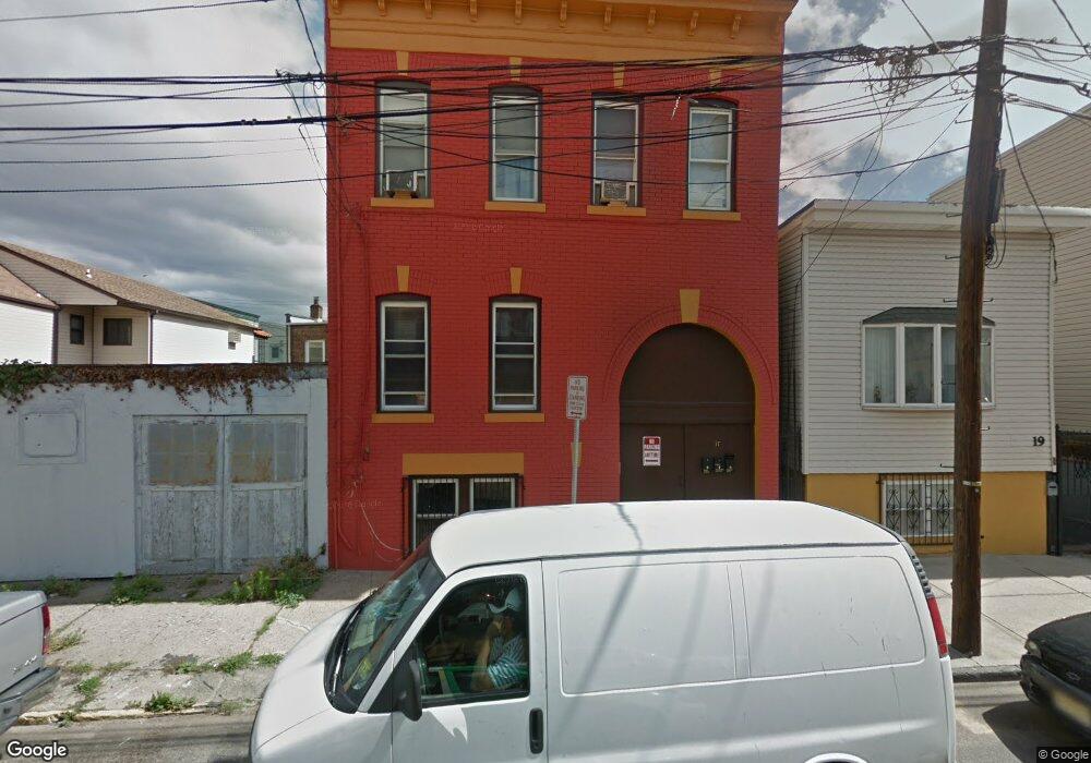
17 Calumet St Newark, NJ 07105
South Ironbound NeighborhoodEstimated Value: $441,000 - $870,131
9
Beds
7
Baths
1,390
Sq Ft
$471/Sq Ft
Est. Value
About This Home
This home is located at 17 Calumet St, Newark, NJ 07105 and is currently estimated at $654,783, approximately $471 per square foot. 17 Calumet St is a home located in Essex County with nearby schools including Oliver Street School, Lafayette Street Elementary School, and Cleveland Elementary School.
Ownership History
Date
Name
Owned For
Owner Type
Purchase Details
Closed on
Jul 11, 2018
Sold by
Amoroso Carlos and Perez-Amoroso Cary E
Bought by
Amoroso Carlos
Current Estimated Value
Purchase Details
Closed on
Sep 2, 2009
Sold by
Amoroso Carlos and Amoroso Cary
Bought by
Amoroso Carlos and Perez Amoroso Cary E
Purchase Details
Closed on
Feb 3, 2003
Sold by
Amoroso Carlos
Bought by
Perez Esther
Purchase Details
Closed on
Dec 30, 2002
Sold by
Perez Esther
Bought by
Amoroso Carlos
Create a Home Valuation Report for This Property
The Home Valuation Report is an in-depth analysis detailing your home's value as well as a comparison with similar homes in the area
Home Values in the Area
Average Home Value in this Area
Purchase History
| Date | Buyer | Sale Price | Title Company |
|---|---|---|---|
| Amoroso Carlos | -- | -- | |
| Amoroso Carlos | -- | None Available | |
| Perez Esther | -- | -- | |
| Amoroso Carlos | -- | -- |
Source: Public Records
Tax History Compared to Growth
Tax History
| Year | Tax Paid | Tax Assessment Tax Assessment Total Assessment is a certain percentage of the fair market value that is determined by local assessors to be the total taxable value of land and additions on the property. | Land | Improvement |
|---|---|---|---|---|
| 2025 | $12,217 | $327,700 | $74,000 | $253,700 |
| 2024 | $12,217 | $327,700 | $74,000 | $253,700 |
| 2022 | $12,243 | $327,700 | $74,000 | $253,700 |
| 2021 | $12,236 | $327,700 | $74,000 | $253,700 |
| 2020 | $12,453 | $327,700 | $74,000 | $253,700 |
| 2019 | $12,325 | $327,700 | $74,000 | $253,700 |
| 2018 | $12,102 | $327,700 | $74,000 | $253,700 |
| 2017 | $11,666 | $327,700 | $74,000 | $253,700 |
| 2016 | $11,273 | $327,700 | $74,000 | $253,700 |
| 2015 | $10,844 | $327,700 | $74,000 | $253,700 |
| 2014 | $10,162 | $327,700 | $74,000 | $253,700 |
Source: Public Records
Map
Nearby Homes
- 7 Calumet St
- 255 E Kinney St
- 353A Adams St
- 340 Adams St
- 22 Nichols St
- 125-129 Malvern St
- 96 Nichols St
- 63 Warwick St
- 111-113 Chestnut St
- 65 Oliver St
- 44 Pacific St Unit 46
- 198 Jefferson St
- 233-235 Adams St
- 228 Murray St Unit 3
- 228 Murray St
- 85 Tichenor St
- 176 Jefferson St
- 272-276 Walnut St Unit 4B
- 272-276 Walnut St
- 195 Walnut St
- 19 Calumet St
- 15 Calumet St
- 21 Calumet St
- 13 Calumet St Unit Ground level 1st flo
- 13 Calumet St Unit 2
- 13 Calumet St
- 23 Calumet St
- 14 Calumet St
- 20 Calumet St
- 20 Calumet St Unit 2
- 22 Calumet St
- 20 Delancey St
- 26 Calumet St
- 22 Delancey St
- 12 Calumet St
- 24 Delancey St
- 162 Pacific St
- 16 Delancey St
- 164 Pacific St
- 10 Calumet St