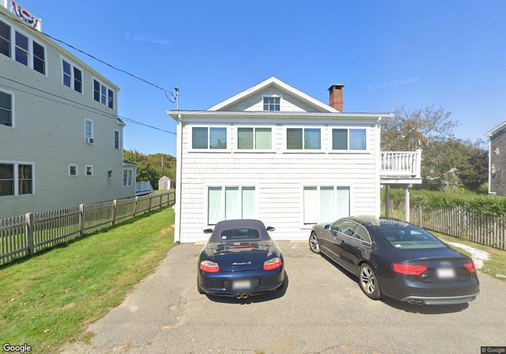
17 Carver Ave Scituate, MA 02066
Estimated Value: $737,000 - $964,000
3
Beds
2
Baths
1,140
Sq Ft
$754/Sq Ft
Est. Value
About This Home
This home is located at 17 Carver Ave, Scituate, MA 02066 and is currently estimated at $859,638, approximately $754 per square foot. 17 Carver Ave is a home located in Plymouth County with nearby schools including Wampatuck Elementary School, Lester J. Gates Middle School, and Scituate High School.
Ownership History
Date
Name
Owned For
Owner Type
Purchase Details
Closed on
Feb 7, 2013
Sold by
Sullivan Tara
Bought by
17 Carver Avenue Rt
Current Estimated Value
Purchase Details
Closed on
Aug 15, 2001
Sold by
Pampalone Andrea J
Bought by
Sullivan Tara
Home Financials for this Owner
Home Financials are based on the most recent Mortgage that was taken out on this home.
Original Mortgage
$254,800
Interest Rate
7.16%
Mortgage Type
Purchase Money Mortgage
Purchase Details
Closed on
Nov 17, 2000
Sold by
Porter Jennella
Bought by
Pampalone Andrea J
Home Financials for this Owner
Home Financials are based on the most recent Mortgage that was taken out on this home.
Original Mortgage
$200,000
Interest Rate
7.78%
Mortgage Type
Purchase Money Mortgage
Purchase Details
Closed on
Dec 5, 1996
Sold by
Murphy Peter J and Murphy Virginia D
Bought by
Porter Jennella
Home Financials for this Owner
Home Financials are based on the most recent Mortgage that was taken out on this home.
Original Mortgage
$128,000
Interest Rate
7.83%
Mortgage Type
Purchase Money Mortgage
Create a Home Valuation Report for This Property
The Home Valuation Report is an in-depth analysis detailing your home's value as well as a comparison with similar homes in the area
Home Values in the Area
Average Home Value in this Area
Purchase History
| Date | Buyer | Sale Price | Title Company |
|---|---|---|---|
| 17 Carver Avenue Rt | $372,400 | -- | |
| Sullivan Tara | $318,500 | -- | |
| Pampalone Andrea J | $287,000 | -- | |
| Porter Jennella | $160,000 | -- |
Source: Public Records
Mortgage History
| Date | Status | Borrower | Loan Amount |
|---|---|---|---|
| Previous Owner | Porter Jennella | $254,800 | |
| Previous Owner | Porter Jennella | $200,000 | |
| Previous Owner | Porter Jennella | $128,000 | |
| Previous Owner | Porter Jennella | $80,000 |
Source: Public Records
Tax History Compared to Growth
Tax History
| Year | Tax Paid | Tax Assessment Tax Assessment Total Assessment is a certain percentage of the fair market value that is determined by local assessors to be the total taxable value of land and additions on the property. | Land | Improvement |
|---|---|---|---|---|
| 2025 | $7,168 | $717,500 | $461,300 | $256,200 |
| 2024 | $6,986 | $674,300 | $419,400 | $254,900 |
| 2023 | $6,369 | $611,500 | $381,200 | $230,300 |
| 2022 | $6,369 | $504,700 | $311,300 | $193,400 |
| 2021 | $6,162 | $462,300 | $296,500 | $165,800 |
| 2020 | $5,982 | $443,100 | $285,000 | $158,100 |
| 2019 | $5,919 | $430,800 | $279,400 | $151,400 |
| 2018 | $5,791 | $415,100 | $278,800 | $136,300 |
| 2017 | $5,709 | $405,200 | $268,900 | $136,300 |
| 2016 | $5,657 | $400,100 | $268,900 | $131,200 |
| 2015 | $5,110 | $390,100 | $258,900 | $131,200 |
Source: Public Records
Map
Nearby Homes
- 209 Hatherly Rd
- 55 Seaside Rd
- 30 Irving Rd
- 7 Borden Rd
- 355 Tilden Rd
- 378 Tilden Rd
- 23 Lois Ann Ct Unit 23
- 50 Oceanside Dr
- 2 Windward Ln
- 22 Kings Way
- 105 Turner Rd
- 148 Tilden Rd
- 46 Marys Ln
- 1 Hillside Rd
- 54 Woodland Rd
- 12 Richfield Rd
- 59 Captain Peirce Rd
- 32 Barker Rd Unit 3
- 18 James Way
- 74 Tilden Rd
- 15 Carver Ave
- 13 Carver Ave
- 18 Carver Ave
- 19 Carver Ave
- 16 Carver Ave
- 16 Carver Ave
- 20 Carver Ave
- 8 Egypt Ave
- 18 Bradford Ave Unit 18
- 22 Bradford Ave
- 23 Carver Ave
- 24 Bradford Ave
- 21 Standish Ave
- 23 Standish Ave
- 25 Standish Ave
- 15 Egypt Ave
- 11 Egypt Ave
- 9 Seaside Rd
- 19 Standish Ave
- 19 Standish Ave Unit Ave