
Seller's Agent in 2026
Diana Mancuso
Keller Williams Realty Metro-Londonderry
(603) 233-5793
2 in this area
20 Total Sales
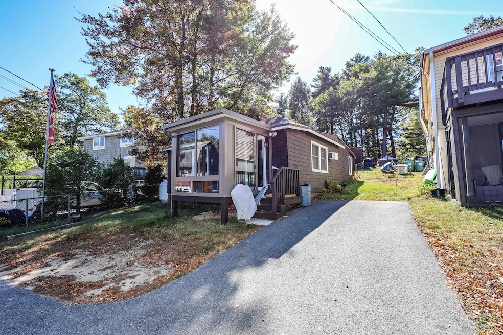


NEW PRICE! Year-round fun on Shadow Lake! Step right across the street to town access. Enclosed porch overlooking beautiful quiet lake – will it be your reading nook? Your office? Or just a comfy spot to entertain friends? Large open common room, eat-in kitchen, spacious step-in shower disability with grab bars. Lights out - no problem gas generator included! 1st floor laundry and utilities. Convenient spot for shopping, travel and entertainment. This property has a holding tank and in use underground oil tank – buyers to do due diligence. Sold as is.
Last Agent to Sell the Property
Keller Williams Realty Metro-Londonderry License #045000 Listed on: 10/04/2025
Last Buyer's Agent
Keller Williams Realty Metro-Londonderry License #045000 Listed on: 10/04/2025
| Date | Type | Sale Price | Title Company |
|---|---|---|---|
| Warranty Deed | $203,900 | -- | |
| Deed | -- | -- |
| Date | Status | Loan Amount | Loan Type |
|---|---|---|---|
| Open | $85,250 | Unknown | |
| Closed | $68,500 | Unknown | |
| Closed | $120,000 | No Value Available |
| Date | Event | Price | List to Sale | Price per Sq Ft |
|---|---|---|---|---|
| 02/25/2026 02/25/26 | Sold | $300,000 | -6.3% | $330 / Sq Ft |
| 02/02/2026 02/02/26 | Pending | -- | -- | -- |
| 01/07/2026 01/07/26 | Price Changed | $320,000 | -3.0% | $352 / Sq Ft |
| 11/13/2025 11/13/25 | Price Changed | $330,000 | -5.7% | $363 / Sq Ft |
| 10/13/2025 10/13/25 | Price Changed | $350,000 | -9.1% | $385 / Sq Ft |
| 10/04/2025 10/04/25 | For Sale | $385,000 | -- | $424 / Sq Ft |
| Year | Tax Paid | Tax Assessment Tax Assessment Total Assessment is a certain percentage of the fair market value that is determined by local assessors to be the total taxable value of land and additions on the property. | Land | Improvement |
|---|---|---|---|---|
| 2024 | $4,888 | $215,900 | $136,900 | $79,000 |
| 2023 | $4,620 | $215,900 | $136,900 | $79,000 |
| 2022 | $4,266 | $215,900 | $136,900 | $79,000 |
| 2021 | $3,910 | $210,000 | $136,900 | $73,100 |
| 2020 | $4,017 | $210,000 | $136,900 | $73,100 |
| 2019 | $3,065 | $135,900 | $95,600 | $40,300 |
| 2018 | $3,165 | $135,900 | $95,600 | $40,300 |
| 2017 | $2,745 | $135,900 | $95,600 | $40,300 |
| 2016 | $2,965 | $135,900 | $95,600 | $40,300 |
| 2015 | $2,952 | $135,900 | $95,600 | $40,300 |
| 2014 | $3,994 | $166,400 | $115,000 | $51,400 |
| 2013 | $3,448 | $146,100 | $115,000 | $31,100 |
Seller's Agent in 2026
Diana Mancuso
Keller Williams Realty Metro-Londonderry
(603) 233-5793
2 in this area
20 Total Sales
Source: PrimeMLS
MLS Number: 5064389
APN: WNDM-000013-K000000-000022
Disclaimer: Certain information contained herein is derived from information provided by parties other than Homes.com. All information provided is deemed reliable, but is not guaranteed to be accurate and should be independently verified.
![]() Copyright 2026 PrimeMLS, Inc. All rights reserved. This information is deemed reliable, but not guaranteed. The data relating to real estate displayed on this display comes in part from the IDX Program of PrimeMLS. The information being provided is for consumers’ personal, non-commercial use and may not be used for any purpose other than to identify prospective properties consumers may be interested in purchasing.
Copyright 2026 PrimeMLS, Inc. All rights reserved. This information is deemed reliable, but not guaranteed. The data relating to real estate displayed on this display comes in part from the IDX Program of PrimeMLS. The information being provided is for consumers’ personal, non-commercial use and may not be used for any purpose other than to identify prospective properties consumers may be interested in purchasing.
Ask me questions while you tour the home.